Enable Location

We need your location to show you interesting places around you

Discover nearby places

Find interesting locations and hidden gems around you

Precise directions

Get accurate directions and distances to places

Your location is never shared with other users. It's only used when you tap the location button.

Bore Sight Range and Compass Swinging Platform at Charters Towers Airfield

Log in to your account

Start exploring — it's free

Trusted by 62,923 travelers worldwide

Continue with Google
Continue with Apple
or

We will send you a code to connect

By continuing, you accept our Terms and Conditions and our Privacy Policy

Check your inbox

We've sent a pincode in your inbox. Please enter the code below.

Bore Sight Range and Compass Swinging Platform at Charters Towers Airfield
Discussion Reviews 1 Photos
1.3k Popularity

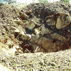
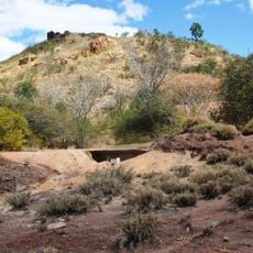
Bore Sight Range and Compass Swinging Platform at Charters Towers Airfield, Military aircraft calibration facility at Charters Towers Airfield, Australia.

The Bore Sight Range and Compass Swinging Platform at Charters Towers Airfield is a military facility with two main parts: a concrete platform for gun alignment and a circular marked area for compass testing. The site allowed technicians to check and adjust navigation and targeting equipment on different aircraft models.

The facility was built between 1942 and 1943 to support the United States Fifth Air Force in operations against Japanese forces in the South Pacific. It played a role in preparing combat aircraft for active duty during that conflict.

The site shows the technical demands of preparing military aircraft for combat during the Second World War. It reflects how closely Australia and the United States worked together in the Pacific region during that period.

The site is open for visitors to explore, though the original concrete structures are delicate and require care. Wear sturdy shoes and stay on marked paths, as the airfield ground can be uneven and rough in places.

This is the only remaining aircraft bore sight range of its type from the Second World War still standing in Queensland, with original concrete elements intact. The design reveals how precisely technicians had to calibrate targeting systems by hand during that era.

The community of curious travelers

AroundUs brings together thousands of curated places, local tips, and hidden gems, enriched daily by 60,000 contributors worldwide.

Start exploring
Location
GPS coordinates
-20.03890,146.27000
Latest update
December 14, 2025 18:10
Reviews
Share your experience

No review yet

Discussions
Start a discussion...

No discussion yet

« Bore Sight Range and Compass Swinging Platform at Charters Towers Airfield - Military aircraft calibration facility at Charters Towers Airfield, Australia » is provided by Around Us (aroundus.com). Images and texts are derived from Wikimedia project under a Creative Commons license. You are allowed to copy, distribute, and modify copies of this page, under the conditions set by the license, as long as this note is clearly visible.

Discover hidden gems everywhere you go!

From secret cafés to breathtaking viewpoints, skip the crowded tourist spots and find places that match your style. Our app makes it easy with voice search, smart filtering, route optimization, and insider tips from travelers worldwide. Download now for the complete mobile experience.

Around Us App Screenshot

A unique approach to discovering new places

Le Figaro

All the places worth exploring

France Info

A tailor-made excursion in just a few clicks

20 Minutes

Around Us
Travel Guide & Maps
Download

Send to your phone

QR Code
1

Open the camera app on your mobile.

2

Point at the QR code with your camera. A notification will appear.

3

Tap the notification to open the link.