Chest opened
+${chestReward.xp} XP
Explorer
NOUVEAU ×${chestReward.collectible.quantity}
tapez pour fermer
Chest locked

Open chests in the app

Around Us is built for your phone — chests unlock when you walk, explore and capture nearby places.

Enable Location

We need your location to show you interesting places around you

Discover nearby places

Find interesting locations and hidden gems around you

Precise directions

Get accurate directions and distances to places

Your location is never shared with other users. It's only used when you tap the location button.

Lehua

Log in to your account

Start exploring — it's free

Trusted by 72,886 travelers worldwide

Continue with Google
Continue with Apple
or

We will send you a code to connect

By continuing, you accept our Terms and Conditions and our Privacy Policy

Check your inbox

We've sent a pincode in your inbox. Please enter the code below.

Lehua
Discussion Reviews 1 Photos
22.2k Popularity

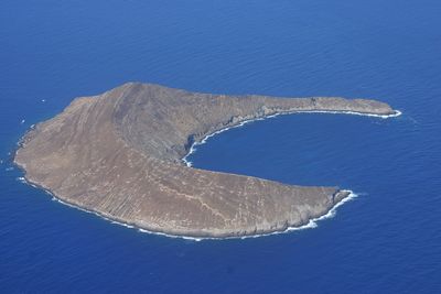
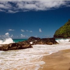
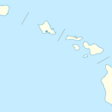
Lehua, Crescent-shaped island north of Niihau, Hawaii, United States.

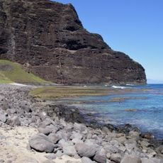
Lehua is an uninhabited volcanic island located off the coast of Kauai with a distinctive crescent shape. It rises roughly 704 feet above the water and covers an area of about 285 acres.

The island was documented by Captain James Cook in 1778 during his Pacific voyage under the name Oreehoua. It later became protected land managed as a state wildlife sanctuary.

The waters surrounding the island hold significance for Niihau residents who gather limpets and maintain connections to ancestral practices.

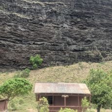
The land is protected as a wildlife sanctuary with strict access limits, requiring permits for any land activities. Visitors are only allowed below the high tide mark, so advance planning is essential.

A United States Coast Guard lighthouse stands atop the summit to assist ships with navigation in these Pacific waters. This maritime landmark remains visible from considerable distances and marks the island's connection to seafaring history.

The community of curious travelers

AroundUs brings together thousands of curated places, local tips, and hidden gems, enriched daily by 60,000 contributors worldwide.

Start exploring
Location
Part of
Hawaiian Islands
GPS coordinates
22.02000,-160.09750
Latest update
December 7, 2025 10:03
Around this place
Nā Pali Coast State Park
United States of America

Nā Pali Coast State Park

50.4 km
Waimea Canyon State Park
United States of America

Waimea Canyon State Park

44.8 km
Kalalau Trail
United States of America

Kalalau Trail

53.2 km
Russian Fort Elizabeth
United States of America

Russian Fort Elizabeth

45.4 km
Hanakapiai Beach
United States of America

Hanakapiai Beach

55.7 km
WWVH
United States of America

WWVH

34.7 km
Polihale State Park
United States of America

Polihale State Park

36.7 km
Glass Beach
United States of America

Glass Beach

54.7 km
Haʻena State Park
United States of America

Haʻena State Park

57.7 km
Hanakapiai Falls
United States of America

Hanakapiai Falls

55 km
United States of America

Makana

57.8 km
Manawaiopuna Falls
United States of America

Manawaiopuna Falls

59.1 km
Limahuli Garden and Preserve
United States of America

Limahuli Garden and Preserve

58.2 km
Alakaʻi Wilderness Preserve
United States of America

Alakaʻi Wilderness Preserve

56.5 km
Cook Landing Site
United States of America

Cook Landing Site

45.2 km
Hanapepe Swinging Bridge
United States of America

Hanapepe Swinging Bridge

54.1 km
Koke'e State Park
United States of America

Koke'e State Park

46.9 km
Civilian Conservation Corps Camp in Koke'e State Park
United States of America

Civilian Conservation Corps Camp in Koke'e State Park

46.6 km
Bishop National Bank of Hawaii
United States of America

Bishop National Bank of Hawaii

44.7 km
Camp Sloggett
United States of America

Camp Sloggett

47.4 km
Gulick-Rowell House
United States of America

Gulick-Rowell House

44.4 km
Yamase Building
United States of America

Yamase Building

44.5 km
Olu Pua Botanical Garden and Plantation
United States of America

Olu Pua Botanical Garden and Plantation

60.3 km
Nualolo Kai Beach
United States of America

Nualolo Kai Beach

43.8 km
Kahana Valley
United States of America

Kahana Valley

50.2 km
Kahuama‘a Flat
United States of America

Kahuama‘a Flat

49.3 km
Miloliʻi Beach
United States of America

Miloliʻi Beach

41.7 km
Maniniholo Dry Cave
United States of America

Maniniholo Dry Cave

59.2 km
Show the full map
Reviews
Share your experience

No review yet

Discussions
Start a discussion...

No discussion yet

« Lehua - Crescent-shaped island north of Niihau, Hawaii, United States » is provided by Around Us (aroundus.com). Images and texts are derived from Wikimedia project under a Creative Commons license. You are allowed to copy, distribute, and modify copies of this page, under the conditions set by the license, as long as this note is clearly visible.

Discover hidden gems everywhere you go!

From secret cafés to breathtaking viewpoints, skip the crowded tourist spots and find places that match your style. Our app makes it easy with voice search, smart filtering, route optimization, and insider tips from travelers worldwide. Download now for the complete mobile experience.

Around Us App Screenshot

A unique approach to discovering new places

Le Figaro

All the places worth exploring

France Info

A tailor-made excursion in just a few clicks

20 Minutes

Around Us
Travel Guide & Maps
Download

Send to your phone

QR Code
1

Open the camera app on your mobile.

2

Point at the QR code with your camera. A notification will appear.

3

Tap the notification to open the link.