Chest opened
+${chestReward.xp} XP
Explorer
NOUVEAU ×${chestReward.collectible.quantity}
tapez pour fermer
Chest locked

Open chests in the app

Around Us is built for your phone — chests unlock when you walk, explore and capture nearby places.

Enable Location

We need your location to show you interesting places around you

Discover nearby places

Find interesting locations and hidden gems around you

Precise directions

Get accurate directions and distances to places

Your location is never shared with other users. It's only used when you tap the location button.

Santa Barbara Island

Log in to your account

Start exploring — it's free

Trusted by 72,963 travelers worldwide

Continue with Google
Continue with Apple
or

We will send you a code to connect

By continuing, you accept our Terms and Conditions and our Privacy Policy

Check your inbox

We've sent a pincode in your inbox. Please enter the code below.

Santa Barbara Island
Discussion Reviews 1 Photos
21.6k Popularity

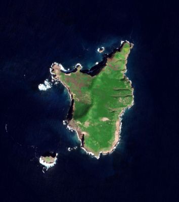
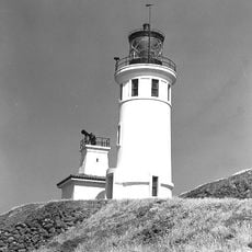
Santa Barbara Island, Pacific island in Channel Islands National Park, California

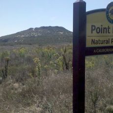
Santa Barbara Island is a small island in Channel Islands National Park off the coast of California. It features steep cliffs that rise to Signal Hill, which towers over 600 feet (180 meters) above the ocean.

The island was mapped by the United States Coast Survey in the 1850s and subsequently used for fishing and seal hunting operations. These early economic activities shaped human use of the remote island for several decades.

Archaeological findings indicate human settlements from indigenous Chumash and Tongva peoples extending beyond 4000 years on this remote island.

The island is best reached by ferry from Ventura Harbor, with the crossing taking about one to two hours across the Pacific. Visitors should prepare for rough conditions and limited facilities on the island.

The island is home to two plant species found nowhere else in the world: Santa Barbara Island live-forever and St. Catherine's lace buckwheat. These rare plants thrive only in the special climate conditions of this remote location.

The community of curious travelers

AroundUs brings together thousands of curated places, local tips, and hidden gems, enriched daily by 60,000 contributors worldwide.

Start exploring
Elevation above the sea
193 m
Part of
Channel Islands of California
GPS coordinates
33.47558,-119.03621
Latest update
December 7, 2025 10:04
Around this place
Point Dume State Beach
United States of America

Point Dume State Beach

62.2 km
747 Wing House
United States of America

747 Wing House

69 km
Marineland of the Pacific
United States of America

Marineland of the Pacific

65.9 km
Zuma Beach
United States of America

Zuma Beach

63.4 km
Wayfarers Chapel
United States of America

Wayfarers Chapel

67.9 km
Trump National Golf Club
United States of America

Trump National Golf Club

69.6 km
Leo Carrillo State Park
United States of America

Leo Carrillo State Park

64 km
Adamson House
United States of America

Adamson House

70.5 km
United States of America

Neptune's Net

64.7 km
Point Mugu State Park
United States of America

Point Mugu State Park

70.3 km
Malibu Lagoon State Beach
United States of America

Malibu Lagoon State Beach

70.3 km
Point Vicente Light
United States of America

Point Vicente Light

65.1 km
Malibu Pier
United States of America

Malibu Pier

70.8 km
Mount Orizaba
United States of America

Mount Orizaba

58.5 km
SS Winfield Scott
United States of America

SS Winfield Scott

68.3 km
Firestone Fieldhouse
United States of America

Firestone Fieldhouse

69.6 km
Robert H. Meyer Memorial State Beach
United States of America

Robert H. Meyer Memorial State Beach

64.4 km
Tuna Club of Avalon
United States of America

Tuna Club of Avalon

67.6 km
Wrigley Botanical Gardens
United States of America

Wrigley Botanical Gardens

66.8 km
Anacapa Island Light
United States of America

Anacapa Island Light

67.1 km
William Wrigley, Jr. Summer Cottage
United States of America

William Wrigley, Jr. Summer Cottage

68.2 km
Point Vicente Interpretive Center
United States of America

Point Vicente Interpretive Center

65.2 km
Campus by the Sea
United States of America

Campus by the Sea

67.4 km
Malaga Cove Library
United States of America

Malaga Cove Library

69.9 km
Trump National Golf Club Los Angeles
United States of America

Trump National Golf Club Los Angeles

70.1 km
Abalone Cove State Marine Conservation Area
United States of America

Abalone Cove State Marine Conservation Area

65.6 km
Encinal Beach
United States of America

Encinal Beach

64.2 km
Upper Beach
United States of America

Upper Beach

67.8 km
Show the full map
Reviews
Share your experience

No review yet

Discussions
Start a discussion...

No discussion yet

« Santa Barbara Island - Pacific island in Channel Islands National Park, California » is provided by Around Us (aroundus.com). Images and texts are derived from Wikimedia project under a Creative Commons license. You are allowed to copy, distribute, and modify copies of this page, under the conditions set by the license, as long as this note is clearly visible.

Discover hidden gems everywhere you go!

From secret cafés to breathtaking viewpoints, skip the crowded tourist spots and find places that match your style. Our app makes it easy with voice search, smart filtering, route optimization, and insider tips from travelers worldwide. Download now for the complete mobile experience.

Around Us App Screenshot

A unique approach to discovering new places

Le Figaro

All the places worth exploring

France Info

A tailor-made excursion in just a few clicks

20 Minutes

Around Us
Travel Guide & Maps
Download

Send to your phone

QR Code
1

Open the camera app on your mobile.

2

Point at the QR code with your camera. A notification will appear.

3

Tap the notification to open the link.