Chest opened
+${chestReward.xp} XP
Explorer
NOUVEAU ×${chestReward.collectible.quantity}
tapez pour fermer
Chest locked

Open chests in the app

Around Us is built for your phone — chests unlock when you walk, explore and capture nearby places.

Enable Location

We need your location to show you interesting places around you

Discover nearby places

Find interesting locations and hidden gems around you

Precise directions

Get accurate directions and distances to places

Your location is never shared with other users. It's only used when you tap the location button.

Log in to your account

Start exploring — it's free

Trusted by 72,877 travelers worldwide

Continue with Google
Continue with Apple
or

We will send you a code to connect

By continuing, you accept our Terms and Conditions and our Privacy Policy

Check your inbox

We've sent a pincode in your inbox. Please enter the code below.

Estrada Courts
Discussion Reviews Photo
11.2k Popularity

Estrada Courts, Public housing complex in Boyle Heights, Los Angeles, United States.

Estrada Courts is a residential complex in Boyle Heights comprising roughly 414 apartments spread across about 30 buildings. The development sits at the intersection of East Olympic Boulevard and South Lorena Street, defining this inner-city neighborhood.

The complex was constructed during 1942 and 1943 in response to housing shortages caused by World War II. An expansion followed in 1954 to meet growing residential needs.

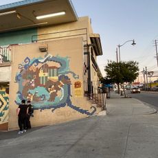
The murals painted across the complex during the 1970s reflect the identity and artistic expression of the Chicano community living here. They serve as a visual representation of the neighborhood's cultural pride and history.

The complex is accessible from outside and offers visitors a glimpse into this typical inner-city residential neighborhood. The murals are best viewed during daylight hours when lighting highlights the details of the artwork.

The complex was unusual for its time in welcoming residents of different backgrounds, standing against the housing segregation practices common elsewhere. This progressive approach made it an early example of integrated housing in Los Angeles.

The community of curious travelers

AroundUs brings together thousands of curated places, local tips, and hidden gems, enriched daily by 60,000 contributors worldwide.

Start exploring
Location
GPS coordinates
34.01900,-118.20800
Latest update
December 8, 2025 13:42
Around this place
Sixth Street Viaduct
United States of America

Sixth Street Viaduct

2.8 km
Linda Vista Community Hospital
United States of America

Linda Vista Community Hospital

2.3 km
Atchison, Topeka and Santa Fe Railway 3751
United States of America

Atchison, Topeka and Santa Fe Railway 3751

1.6 km
Japanese American National Museum
United States of America

Japanese American National Museum

4.4 km
Evergreen Cemetery
United States of America

Evergreen Cemetery

2.7 km
United States of America

South Central Farm

3.3 km
Sears, Roebuck & Company Mail Order Building
United States of America

Sears, Roebuck & Company Mail Order Building

1.3 km
Coca-Cola Building
United States of America

Coca-Cola Building

3.6 km
Skid Row City Limits Mural
United States of America

Skid Row City Limits Mural

4.4 km
Mariachi Plaza
United States of America

Mariachi Plaza

3.3 km
Breed Street Shul
United States of America

Breed Street Shul

3.1 km
Atomic Cafe
United States of America

Atomic Cafe

4.3 km
El Mercado de Los Angeles
United States of America

El Mercado de Los Angeles

2.4 km
Fire Station No. 30, Engine Company No. 30
United States of America

Fire Station No. 30, Engine Company No. 30

3.8 km
Ralph J. Bunche House
United States of America

Ralph J. Bunche House

4.2 km
Lincoln Theatre
United States of America

Lincoln Theatre

4.2 km
Boyle Hotel – Cummings Block
United States of America

Boyle Hotel – Cummings Block

3.4 km
Santa Fe Freight Depot
United States of America

Santa Fe Freight Depot

3.7 km
Punchbowl Formation
United States of America

Punchbowl Formation

2.2 km
Bethlehem Baptist Church
United States of America

Bethlehem Baptist Church

4.3 km
Robert Louis Stevenson Branch
United States of America

Robert Louis Stevenson Branch

1.4 km
Malabar Branch
United States of America

Malabar Branch

3.6 km
Catalina Swimwear Building
United States of America

Catalina Swimwear Building

4.4 km
Little Tokyo
United States of America

Little Tokyo

4.5 km
Luna Luna
United States of America

Luna Luna

2.8 km
Higashi Hongan-ji Buddhist Temple
United States of America

Higashi Hongan-ji Buddhist Temple

4.3 km
African American Firefighter Museum
United States of America

African American Firefighter Museum

3.8 km
Cesar Chavez Avenue Viaduct
United States of America

Cesar Chavez Avenue Viaduct

4.4 km
Show the full map
Reviews
Share your experience

No review yet

Discussions
Start a discussion...

No discussion yet

« Estrada Courts - Public housing complex in Boyle Heights, Los Angeles, United States » is provided by Around Us (aroundus.com). Images and texts are derived from Wikimedia project under a Creative Commons license. You are allowed to copy, distribute, and modify copies of this page, under the conditions set by the license, as long as this note is clearly visible.

Discover hidden gems everywhere you go!

From secret cafés to breathtaking viewpoints, skip the crowded tourist spots and find places that match your style. Our app makes it easy with voice search, smart filtering, route optimization, and insider tips from travelers worldwide. Download now for the complete mobile experience.

Around Us App Screenshot

A unique approach to discovering new places

Le Figaro

All the places worth exploring

France Info

A tailor-made excursion in just a few clicks

20 Minutes

Around Us
Travel Guide & Maps
Download

Send to your phone

QR Code
1

Open the camera app on your mobile.

2

Point at the QR code with your camera. A notification will appear.

3

Tap the notification to open the link.