Enable Location

We need your location to show you interesting places around you

Discover nearby places

Find interesting locations and hidden gems around you

Precise directions

Get accurate directions and distances to places

Your location is never shared with other users. It's only used when you tap the location button.

Douglas

Log in to your account

Join the adventure

Create your free account and start exploring (like 60k+ others)

We will send you a code to connect

or
Continue with Google
Continue with Apple
By continuing, you accept our Terms and Conditions and our Privacy Policy

Check your inbox

We've sent a pincode in your inbox. Please enter the code below.

Douglas, Border town in Cochise County, Arizona, United States

Description

Douglas is a border city in Cochise County, Arizona, positioned directly along the Mexico-United States boundary where daily commerce and social interaction connect two countries. The city sits at an elevation of about 1,221 meters and functions as a key crossing point for both pedestrians and vehicles.

History

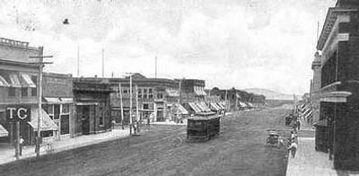
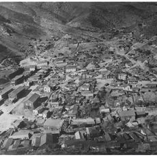
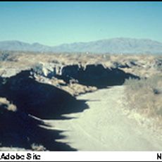
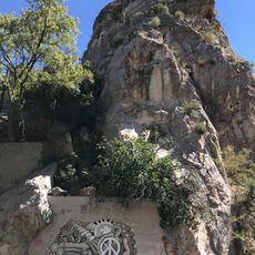
Founded in 1905 as a copper smelting center for ore from nearby Bisbee mines, the city was named after mining pioneer James Douglas. This industrial origin shaped its early growth and established it as a regional economic hub during the early 20th century.

Culture

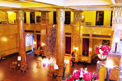
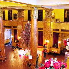
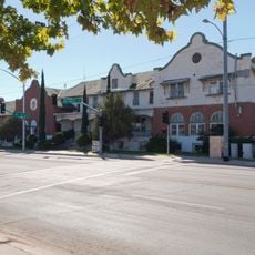
The Gadsden Hotel displays early 1900s craftsmanship with marble columns and colored glass windows throughout its public spaces. Walking through its halls gives you a sense of the city's prosperous past and its role as a center of commerce.

Practical

Visitors need a valid passport to cross between Douglas and the adjacent Mexican city of Agua Prieta. Both pedestrian and vehicle crossing points are available, allowing you to choose the method that works best for your trip.

Did you know?

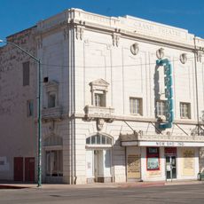
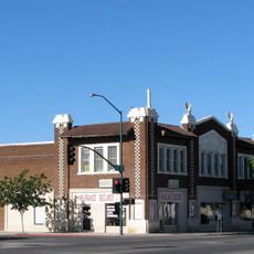
The Douglas Grand Theater was the largest entertainment venue between Los Angeles and San Antonio in the early 1900s, reflecting the city's former status as a cultural destination. This historic building still stands as a reminder of when this border city attracted travelers passing through the region.

Location
Elevation above the sea
1,221 m
Part of
Mexico–United States border
Shares border with
Pirtleville
GPS coordinates
31.34500,-109.54139
Latest update
December 14, 2025 19:04

AroundUs brings together thousands of curated places, local tips, and hidden gems, enriched daily by 60,000 contributors worldwide. Discover all places nearby (Cochise County).

Around this place
Gadsden Hotel
United States of America

Gadsden Hotel

1.2 km
San Bernardino Ranch
United States of America

San Bernardino Ranch

24.9 km
San Bernardino National Wildlife Refuge
United States of America

San Bernardino National Wildlife Refuge

26.8 km
Leslie Canyon National Wildlife Refuge
United States of America

Leslie Canyon National Wildlife Refuge

27.2 km
United States of America

Arizona Cactus Botanical Garden

31.8 km
Bisbee Historic District
United States of America

Bisbee Historic District

37 km
Grand Theatre
United States of America

Grand Theatre

1.7 km
Phelps Dodge General Office Building
United States of America

Phelps Dodge General Office Building

37.1 km
St. Patrick's Roman Catholic Church
United States of America

St. Patrick's Roman Catholic Church

37.8 km
Double Adobe Site
United States of America

Double Adobe Site

947 m
Plaza Azueta
Mexico

Plaza Azueta

2.6 km
Douglas Historic District
United States of America

Douglas Historic District

1.2 km
El Paso and Southwestern Railroad YMCA
United States of America

El Paso and Southwestern Railroad YMCA

1.5 km
Bisbee Residential Historic District
United States of America

Bisbee Residential Historic District

38 km
Bisbee Woman's Club Clubhouse
United States of America

Bisbee Woman's Club Clubhouse

37.2 km
United States Post Office and Customs House–Douglas Main
United States of America

United States Post Office and Customs House–Douglas Main

1.1 km
Douglas Residential Historic District
United States of America

Douglas Residential Historic District

532 m
United States of America

Castle Rock

37.4 km
United States of America

Bucky O'Neill Hill

36.9 km
Castle Rock
United States of America

Castle Rock

37.4 km
United States of America

Lewis Monument

27.5 km
Evergreen Cemetery
United States of America

Evergreen Cemetery

34.6 km
United States of America

City of Douglas Municipal Golf Course

3.2 km
United States of America

Car

37.2 km
Mexico

TOBOGÁN AQUAMUNDO

4.4 km
United States of America

Iron Man

37.6 km
United States of America

Scenic viewpoint

29.7 km
United States of America

Scenic viewpoint

29.7 km
Show the full map
« Douglas - Border town in Cochise County, Arizona, United States » is provided by Around Us (aroundus.com). Images and texts are derived from Wikimedia project under a Creative Commons license. You are allowed to copy, distribute, and modify copies of this page, under the conditions set by the license, as long as this note is clearly visible.

Discover hidden gems everywhere you go!

From secret cafés to breathtaking viewpoints, skip the crowded tourist spots and find places that match your style. Our app makes it easy with voice search, smart filtering, route optimization, and insider tips from travelers worldwide. Download now for the complete mobile experience.

Around Us App Screenshot

A unique approach to discovering new places

Le Figaro

All the places worth exploring

France Info

A tailor-made excursion in just a few clicks

20 Minutes

Around Us
Travel Guide & Maps
Download

Send to your phone

QR Code
1

Open the camera app on your mobile.

2

Point at the QR code with your camera. A notification will appear.

3

Tap the notification to open the link.