Enable Location

We need your location to show you interesting places around you

Discover nearby places

Find interesting locations and hidden gems around you

Precise directions

Get accurate directions and distances to places

Your location is never shared with other users. It's only used when you tap the location button.

Cascada de Cacalotenango

Log in to your account

Start exploring — it's free

Trusted by 63,133 travelers worldwide

Continue with Google
Continue with Apple
or

We will send you a code to connect

By continuing, you accept our Terms and Conditions and our Privacy Policy

Check your inbox

We've sent a pincode in your inbox. Please enter the code below.

Cascada de Cacalotenango
Discussion Reviews 1 Photos 1 Collections
60+ Popularity

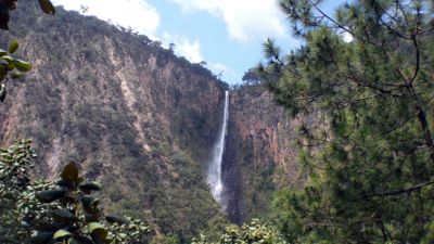
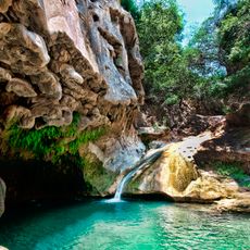
Cascada de Cacalotenango, Natural waterfall in Taxco de Alarcón, Mexico.

Cascada de Cacalotenango is a waterfall dropping roughly 80 meters from a rocky ledge in the Guerrero mountains. The water falls into a natural pool below, surrounded by dense forest that covers the steep hillside.

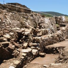
The waterfall formed through the Plan de Campos stream, which originates at El Cedro mountain and has carved the landscape over centuries. This constant flow has shaped both the rock formations and the valley where the nearby community settled.

The nearby community has long depended on the waterfall's water for farming and daily needs, making it a vital part of local life.

To reach the waterfall from Taxco de Alarcón, take the state road heading toward Ixcateopan de Cuauhtémoc and look for local access points or hiking trails. The visit is easier during drier months when paths are less slippery.

The waterfall roars powerfully and loudly from the heights, especially after rain, creating a fine mist that fills the entire area around it. This raw and forceful experience makes each visit memorable and immediate.

The community of curious travelers

AroundUs brings together thousands of curated places, local tips, and hidden gems, enriched daily by 60,000 contributors worldwide.

Start exploring
GPS coordinates
18.55981,-99.66344
Latest update
December 6, 2025 19:07
Natural and historic sites across Guerrero state Mexico

Guerrero brings together Pacific coastline, colonial towns, and archaeological sites from pre-Hispanic civilizations. The landscape ranges from sandy beaches and offshore islands to cave systems and waterfalls in the mountainous interior of the Sierra Madre del Sur. Taxco displays baroque churches...

Reviews
Share your experience

No review yet

Discussions
Start a discussion...

No discussion yet

« Cascada de Cacalotenango - Natural waterfall in Taxco de Alarcón, Mexico » is provided by Around Us (aroundus.com). Images and texts are derived from Wikimedia project under a Creative Commons license. You are allowed to copy, distribute, and modify copies of this page, under the conditions set by the license, as long as this note is clearly visible.

Discover hidden gems everywhere you go!

From secret cafés to breathtaking viewpoints, skip the crowded tourist spots and find places that match your style. Our app makes it easy with voice search, smart filtering, route optimization, and insider tips from travelers worldwide. Download now for the complete mobile experience.

Around Us App Screenshot

A unique approach to discovering new places

Le Figaro

All the places worth exploring

France Info

A tailor-made excursion in just a few clicks

20 Minutes

Around Us
Travel Guide & Maps
Download

Send to your phone

QR Code
1

Open the camera app on your mobile.

2

Point at the QR code with your camera. A notification will appear.

3

Tap the notification to open the link.