Enable Location

We need your location to show you interesting places around you

Discover nearby places

Find interesting locations and hidden gems around you

Precise directions

Get accurate directions and distances to places

Your location is never shared with other users. It's only used when you tap the location button.

Sabine Bank Light

Log in to your account

Start exploring — it's free

Trusted by 62,522 travelers worldwide

Continue with Google
Continue with Apple
or

We will send you a code to connect

By continuing, you accept our Terms and Conditions and our Privacy Policy

Check your inbox

We've sent a pincode in your inbox. Please enter the code below.

Sabine Bank Light

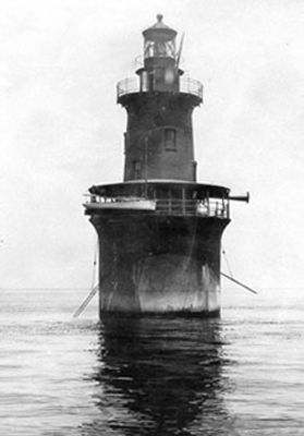
Sabine Bank Light, Maritime lighthouse in Jefferson County, United States

Sabine Bank Light is a lighthouse constructed from iron and caisson materials, standing in the Gulf of Mexico south of the Sabine River mouth. The structure marks a dangerous shallow area that posed risks to passing vessels.

Congress approved funding for this lighthouse between 1900 and 1901 after numerous vessels ran aground on the dangerous Sabine Bank shoals. The structure was built to help guide ships more safely through those treacherous waters.

The structure reflects early twentieth-century maritime engineering practices, and its original lantern room is displayed at Lions Park in Sabine Pass. Visitors can see how this equipment guided ships through dangerous waters.

The lighthouse has operated on solar power since 1971 to guide vessels through shipping channels near Port Arthur. The structure sits in open water and is only accessible by boat.

Local fishermen call this navigation aid The Eighteen Mile Light, named for its distance from the Coast Guard Lifeboat Station. The nickname reflects how working sailors measure their location and find their way on these waters.

The community of curious travelers

AroundUs brings together thousands of curated places, local tips, and hidden gems, enriched daily by 60,000 contributors worldwide.

Start exploring
Location
Inception
1904
Made from material
caisson, iron
GPS coordinates
29.47270,-93.72260
Latest update
December 14, 2025 17:00
Around this place
Spindletop
United States of America

Spindletop

69.7 km
Rainbow Bridge
United States of America

Rainbow Bridge

58.3 km
Sea Rim State Park
United States of America

Sea Rim State Park

38.7 km
Provost Umphrey Stadium
United States of America

Provost Umphrey Stadium

71.8 km
Spindletop-Gladys City Boomtown Museum
United States of America

Spindletop-Gladys City Boomtown Museum

71.2 km
Sabine National Wildlife Refuge
United States of America

Sabine National Wildlife Refuge

51 km
Sabine Pass Light
United States of America

Sabine Pass Light

29.8 km
W. H. Stark House
United States of America

W. H. Stark House

69 km
McFaddin and Texas Point National Wildlife Refuges
United States of America

McFaddin and Texas Point National Wildlife Refuges

46.7 km
Cameron Prairie National Wildlife Refuge
United States of America

Cameron Prairie National Wildlife Refuge

64.5 km
Vincent–Beck Stadium
United States of America

Vincent–Beck Stadium

71.2 km
Stark Museum of Art
United States of America

Stark Museum of Art

69.1 km
Dishman Art Museum
United States of America

Dishman Art Museum

72.4 km
Lamar Soccer Complex
United States of America

Lamar Soccer Complex

71 km
Martin Luther King Bridge
United States of America

Martin Luther King Bridge

47.7 km
Mary and John Gray Library
United States of America

Mary and John Gray Library

72 km
Pompeiian Villa
United States of America

Pompeiian Villa

49.6 km
Orange County Courthouse
United States of America

Orange County Courthouse

68.7 km
Rose Hill
United States of America

Rose Hill

50 km
Port Arthur Federated Women's Clubhouse
United States of America

Port Arthur Federated Women's Clubhouse

49.5 km
Holly Beach
United States of America

Holly Beach

42.1 km
Eddingston Court
United States of America

Eddingston Court

50.6 km
Marconi Tower at Port Arthur College
United States of America

Marconi Tower at Port Arthur College

49.4 km
Gates Memorial Library
United States of America

Gates Memorial Library

49.3 km
Texas Point National Wildlife Refuge
United States of America

Texas Point National Wildlife Refuge

30 km
Veterans Memorial Bridge
United States of America

Veterans Memorial Bridge

58.3 km
McFaddin National Wildlife Refuge
United States of America

McFaddin National Wildlife Refuge

49.5 km
Interstate 10 Bridge
United States of America

Interstate 10 Bridge

72.9 km
Show the full map
« Sabine Bank Light - Maritime lighthouse in Jefferson County, United States » is provided by Around Us (aroundus.com). Images and texts are derived from Wikimedia project under a Creative Commons license. You are allowed to copy, distribute, and modify copies of this page, under the conditions set by the license, as long as this note is clearly visible.

Discover hidden gems everywhere you go!

From secret cafés to breathtaking viewpoints, skip the crowded tourist spots and find places that match your style. Our app makes it easy with voice search, smart filtering, route optimization, and insider tips from travelers worldwide. Download now for the complete mobile experience.

Around Us App Screenshot

A unique approach to discovering new places

Le Figaro

All the places worth exploring

France Info

A tailor-made excursion in just a few clicks

20 Minutes

Around Us
Travel Guide & Maps
Download

Send to your phone

QR Code
1

Open the camera app on your mobile.

2

Point at the QR code with your camera. A notification will appear.

3

Tap the notification to open the link.