Enable Location

We need your location to show you interesting places around you

Discover nearby places

Find interesting locations and hidden gems around you

Precise directions

Get accurate directions and distances to places

Your location is never shared with other users. It's only used when you tap the location button.

Log in to your account

Start exploring — it's free

Trusted by 61,369 travelers worldwide

Continue with Google
Continue with Apple
or

We will send you a code to connect

By continuing, you accept our Terms and Conditions and our Privacy Policy

Check your inbox

We've sent a pincode in your inbox. Please enter the code below.

Big Lake Wildlife Management Area

Big Lake Wildlife Management Area, Protected wetland area in Franklin, Tensas, and Madison Parish, Louisiana, US

Description

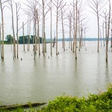
Big Lake Wildlife Management Area spans approximately 19,000 acres of wetlands, forests, and open fields along the Tensas River in northeastern Louisiana. The landscape consists of a mix of different habitats, from dense woodland to open water areas.

History

The Louisiana Department of Wildlife and Fisheries created this protected space between 1983 and 1985 through three separate land purchases. Funding from the Rockefeller Foundation made the establishment of this important conservation area possible.

Culture

Hunters and birdwatchers use this area regularly, following strict seasonal rules and zone boundaries that have become part of local outdoor traditions. The landscape has become a valued gathering place for people wanting direct contact with Louisiana's natural world.

Practical

The area permits recreational activities like birdwatching and hiking, with special permits required for hunting during certain seasons. Access is easiest from towns in the surrounding parishes.

Did you know?

The Tensas River creates natural boundaries as it flows through the land, dividing different habitats. These water corridors support animal species that thrive in conditions found nowhere else in the region.

GPS coordinates
32.20056,-91.41139
Latest update
December 14, 2025 18:14

AroundUs brings together thousands of curated places, local tips, and hidden gems, enriched daily by 60,000 contributors worldwide. Discover all places nearby (United States of America).

Around this place
Poverty Point Reservoir State Park
United States of America

Poverty Point Reservoir State Park

32.3 km
Winter Quarters State Historic Site
United States of America

Winter Quarters State Historic Site

30.5 km
United States of America

5th United States Colored Heavy Artillery Regiment

39.6 km
Fitzhugh Mounds
United States of America

Fitzhugh Mounds

33.9 km
United States of America

Mott Archaeological Preserve

15 km
High Delta Safari Park
United States of America

High Delta Safari Park

41.6 km
Oakland Memorial Chapel
United States of America

Oakland Memorial Chapel

44.3 km
Van Dorn House
United States of America

Van Dorn House

45.7 km
Grand Gulf Military State Park
United States of America

Grand Gulf Military State Park

38.1 km
Crescent Plantation
United States of America

Crescent Plantation

29.8 km
Sacred Heart Roman Catholic Church
United States of America

Sacred Heart Roman Catholic Church

38.6 km
Rodney Presbyterian Church
United States of America

Rodney Presbyterian Church

42.2 km
Hermione
United States of America

Hermione

31.6 km
Linwood Plantation Manager's House
United States of America

Linwood Plantation Manager's House

29.3 km
Bethel Presbyterian Church
United States of America

Bethel Presbyterian Church

42.3 km
Alcorn State University Historic District
United States of America

Alcorn State University Historic District

43.8 km
Scottland Plantation House
United States of America

Scottland Plantation House

30.3 km
Montrose Plantation House
United States of America

Montrose Plantation House

29 km
Canemount
United States of America

Canemount

43.4 km
Yokena Presbyterian Church
United States of America

Yokena Presbyterian Church

44.3 km
Raffman Site
United States of America

Raffman Site

31 km
Madison Parish Courthouse
United States of America

Madison Parish Courthouse

31.2 km
Waterproof High School
United States of America

Waterproof High School

43.6 km
Tensas Parish Courthouse
United States of America

Tensas Parish Courthouse

36 km
St. Joseph Historic District
United States of America

St. Joseph Historic District

35.7 km
Winnsboro Commercial Historic District
United States of America

Winnsboro Commercial Historic District

29.3 km
Vickers House
United States of America

Vickers House

45.7 km
Lake Bruin State Park
United States of America

Lake Bruin State Park

33.3 km
Show the full map
« Big Lake Wildlife Management Area - Protected wetland area in Franklin, Tensas, and Madison Parish, Louisiana, US » is provided by Around Us (aroundus.com). Images and texts are derived from Wikimedia project under a Creative Commons license. You are allowed to copy, distribute, and modify copies of this page, under the conditions set by the license, as long as this note is clearly visible.

Discover hidden gems everywhere you go!

From secret cafés to breathtaking viewpoints, skip the crowded tourist spots and find places that match your style. Our app makes it easy with voice search, smart filtering, route optimization, and insider tips from travelers worldwide. Download now for the complete mobile experience.

Around Us App Screenshot

A unique approach to discovering new places

Le Figaro

All the places worth exploring

France Info

A tailor-made excursion in just a few clicks

20 Minutes

Around Us
Travel Guide & Maps
Download

Send to your phone

QR Code
1

Open the camera app on your mobile.

2

Point at the QR code with your camera. A notification will appear.

3

Tap the notification to open the link.