Enable Location

We need your location to show you interesting places around you

Discover nearby places

Find interesting locations and hidden gems around you

Precise directions

Get accurate directions and distances to places

Your location is never shared with other users. It's only used when you tap the location button.

Log in to your account

Start exploring — it's free

Trusted by 63,312 travelers worldwide

Continue with Google
Continue with Apple
or

We will send you a code to connect

By continuing, you accept our Terms and Conditions and our Privacy Policy

Check your inbox

We've sent a pincode in your inbox. Please enter the code below.

Mott Archaeological Preserve
Discussion Reviews Photo
2.2k Popularity

Mott Archaeological Preserve, Archaeological site in Franklin Parish, Louisiana, US.

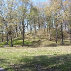
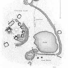
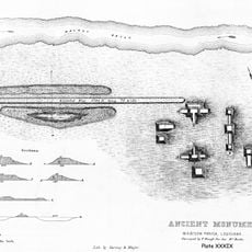
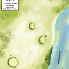
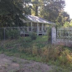
Mott Archaeological Preserve is an archaeological site featuring eleven earthen mounds along Bayou Macon's western bank in northern Louisiana. These mounds were constructed by Native American communities over many centuries, varying in size and arrangement with the largest covering approximately two acres at its base.

Early archaeological work at the site began around 1900, with subsequent investigations continuing through the early 1900s and later university research in the 1960s. These studies revealed that the location was occupied and shaped by different cultures spanning more than a thousand years.

The mounds reflect different eras of Native American occupation, each with its own cultural identity and way of organizing community spaces. Visitors can observe how the arrangement and size of these earthworks reveal the priorities and practices of the people who built them.

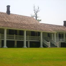
The site is located away from major roads and is best accessed by car; plan time to explore the various mounds at a comfortable pace. Wear appropriate footwear and clothing since the ground can become muddy, especially after rain, and pathways are not paved throughout the property.

The tallest mound rises about 26 feet and stands beside a large central plaza that was intentionally created as a gathering space by the original builders. This arrangement indicates that the site functioned as a regional meeting place and ceremonial center.

The community of curious travelers

AroundUs brings together thousands of curated places, local tips, and hidden gems, enriched daily by 60,000 contributors worldwide.

Start exploring
Location
GPS coordinates
32.30920,-91.50560
Latest update
December 13, 2025 17:09
Around this place
Poverty Point
United States of America

Poverty Point

37.5 km
Vicksburg Bridge
United States of America

Vicksburg Bridge

56.2 km
Old Vicksburg Bridge
United States of America

Old Vicksburg Bridge

56.5 km
Chennault Aviation and Military Museum
United States of America

Chennault Aviation and Military Museum

56.3 km
Poverty Point Reservoir State Park
United States of America

Poverty Point Reservoir State Park

19.3 km
Winter Quarters State Historic Site
United States of America

Winter Quarters State Historic Site

45.3 km
Jordan Mounds
United States of America

Jordan Mounds

44.3 km
Fitzhugh Mounds
United States of America

Fitzhugh Mounds

40 km
High Delta Safari Park
United States of America

High Delta Safari Park

28.4 km
Grand Gulf Military State Park
United States of America

Grand Gulf Military State Park

52 km
Crescent Plantation
United States of America

Crescent Plantation

32.8 km
Sacred Heart Roman Catholic Church
United States of America

Sacred Heart Roman Catholic Church

52.5 km
Rodney Presbyterian Church
United States of America

Rodney Presbyterian Church

57.1 km
Peck Mounds
United States of America

Peck Mounds

55.6 km
Hermione
United States of America

Hermione

32.2 km
Linwood Plantation Manager's House
United States of America

Linwood Plantation Manager's House

44 km
Scottland Plantation House
United States of America

Scottland Plantation House

30.9 km
Montrose Plantation House
United States of America

Montrose Plantation House

34.5 km
Yokena Presbyterian Church
United States of America

Yokena Presbyterian Church

55.2 km
Raffman Site
United States of America

Raffman Site

23.6 km
Madison Parish Courthouse
United States of America

Madison Parish Courthouse

31.9 km
Waterproof High School
United States of America

Waterproof High School

56.8 km
Boscobel Cottage
United States of America

Boscobel Cottage

55.3 km
Tensas Parish Courthouse
United States of America

Tensas Parish Courthouse

50.9 km
St. Joseph Historic District
United States of America

St. Joseph Historic District

50.6 km
Winnsboro Commercial Historic District
United States of America

Winnsboro Commercial Historic District

25.8 km
Vickers House
United States of America

Vickers House

33.8 km
Lake Bruin State Park
United States of America

Lake Bruin State Park

48.3 km
Show the full map
Reviews
Share your experience

No review yet

Discussions
Start a discussion...

No discussion yet

« Mott Archaeological Preserve - Archaeological site in Franklin Parish, Louisiana, US » is provided by Around Us (aroundus.com). Images and texts are derived from Wikimedia project under a Creative Commons license. You are allowed to copy, distribute, and modify copies of this page, under the conditions set by the license, as long as this note is clearly visible.

Discover hidden gems everywhere you go!

From secret cafés to breathtaking viewpoints, skip the crowded tourist spots and find places that match your style. Our app makes it easy with voice search, smart filtering, route optimization, and insider tips from travelers worldwide. Download now for the complete mobile experience.

Around Us App Screenshot

A unique approach to discovering new places

Le Figaro

All the places worth exploring

France Info

A tailor-made excursion in just a few clicks

20 Minutes

Around Us
Travel Guide & Maps
Download

Send to your phone

QR Code
1

Open the camera app on your mobile.

2

Point at the QR code with your camera. A notification will appear.

3

Tap the notification to open the link.