Poverty Point

Log in to your account

AroundUs is a community-driven map of interesting places, built by curious explorers like you. It grows with every review, story, and photo you share.
Connect to save your favorite spots, contribute locations, and create personalized routes.
Continue with Google
Continue with Apple
Continue with X
Continue with Facebook
Continue with email
By continuing, you accept our Terms and Conditions and our Privacy Policy
Create an account
Add to collection
Map
Suggest a change
Share

Poverty Point, Archaeological site in West Carroll Parish, Louisiana, US

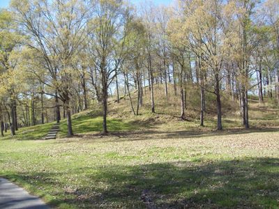
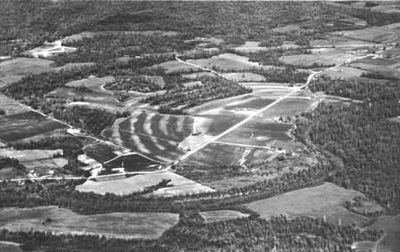
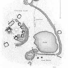
Poverty Point is an archaeological site in West Carroll Parish, Louisiana, made up of six semicircular earthen ridges and several mounds spread across roughly 368 hectares. The layout shows a deliberate pattern with openings facing east, suggesting a planned settlement structure.

The site was built between 1700 and 1100 BC when communities moved roughly 1.5 million cubic meters of earth without metal tools or pack animals. Around 1100 BC, the inhabitants left for unknown reasons, and the settlement was never reoccupied.

The name comes from a 19th-century plantation that once occupied the land, unrelated to the original builders. Today, visitors from the region come to walk the preserved earthworks and learn about the early inhabitants of the Mississippi valley.

The grounds are open daily from 9 AM to 5 PM, with guided walks and tram rides available through the earthworks. Admission costs 4 dollars per person, and comfortable shoes are recommended since some paths cross uneven terrain.

The largest mound reaches 22 meters (72 feet) in height and 215 meters (705 feet) in width, and studies suggest it was raised in just three months. Archaeologists also found thousands of small baked clay balls, likely used as cooking stones and evidence of the absence of pottery during this period.

Location: West Carroll Parish

Operator: United States National Park Service;UNESCO

Website: https://nps.gov/popo

GPS coordinates: 32.63670,-91.41140

Latest update: December 12, 2025 17:43

Photos
Louisiana museums: historic plantations, archaeological sites, and botanical gardens

Louisiana preserves a diverse heritage through its plantations, museums, and natural areas. This collection includes sites where French colonial architecture can be seen along the Cane River, plantation buildings like Melrose and Frogmore that reflect cotton farming and African-American history, and...

Around this place
Poverty Point Reservoir State Park
United States of America

Poverty Point Reservoir State Park

18.9 km
United States of America

Marsden Mounds

18.3 km
Jordan Mounds
United States of America

Jordan Mounds

32.7 km
High Delta Safari Park
United States of America

High Delta Safari Park

12.6 km
United States of America

Transylvania Mounds

20.2 km
United States of America

Julice Mound

19.1 km
Hermione
United States of America

Hermione

33.1 km
Scottland Plantation House
United States of America

Scottland Plantation House

33 km
United States of America

Bloom's Arcade

32.7 km
Fiske Theatre
United States of America

Fiske Theatre

25.1 km
United States of America

Buckmeadow Plantation House

29.1 km
Louisiana State Cotton Museum
United States of America

Louisiana State Cotton Museum

27.7 km
Raffman Site
United States of America

Raffman Site

19.2 km
Madison Parish Courthouse
United States of America

Madison Parish Courthouse

33 km
United States of America

Tallulah Men's Club Building

33.1 km
United States of America

Byerley House

29.1 km
United States of America

Lake Providence Residential Historic District

29 km
United States of America

Old Courthouse Square

29 km
United States of America

Bear Lake Club, Ltd., Clubhouse

23.2 km
United States of America

Fischer House

28.6 km
United States of America

Nelson House

28.7 km
United States of America

Oak Grove Community House

25.5 km
Lake Providence Commercial Historic District
United States of America

Lake Providence Commercial Historic District

29.3 km
United States of America

Tallulah Book Club Building

33.3 km
United States of America

Kell House

33 km
United States of America

Miles-Hanna House

21.3 km
United States of America

Horseshoe Lake

28.4 km
United States of America

Black Bear Golf Club

12 km
Show the full map
Reviews

Visited this place? Tap the stars to rate it and share your experience / photos with the community! Try now! You can cancel it anytime.

« Poverty Point - Archaeological site in West Carroll Parish, Louisiana, US » is provided by Around Us (aroundus.com). Images and texts are derived from Wikimedia project under a Creative Commons license. You are allowed to copy, distribute, and modify copies of this page, under the conditions set by the license, as long as this note is clearly visible.

Discover hidden gems everywhere you go!

From secret cafés to breathtaking viewpoints, skip the crowded tourist spots and find places that match your style. Our app makes it easy with voice search, smart filtering, route optimization, and insider tips from travelers worldwide. Download now for the complete mobile experience.

Around Us App Screenshot

A unique approach to discovering new places

Le Figaro

All the places worth exploring

France Info

A tailor-made excursion in just a few clicks

20 Minutes