Enable Location

We need your location to show you interesting places around you

Discover nearby places

Find interesting locations and hidden gems around you

Precise directions

Get accurate directions and distances to places

Your location is never shared with other users. It's only used when you tap the location button.

Log in to your account

Start exploring — it's free

Trusted by 62,442 travelers worldwide

Continue with Google
Continue with Apple
or

We will send you a code to connect

By continuing, you accept our Terms and Conditions and our Privacy Policy

Check your inbox

We've sent a pincode in your inbox. Please enter the code below.

Transylvania Mounds

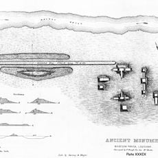
Transylvania Mounds, Archaeological site in East Carroll Parish, Louisiana.

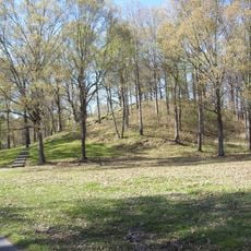
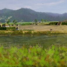
Transylvania Mounds is an archaeological complex featuring two central plazas ringed by multiple earthen mounds of varying sizes. The largest structure rises to about 34 feet, demonstrating the substantial construction efforts required for this ceremonial center.

The site shows evidence of occupation spanning from around 700 to 1541 CE, indicating continuous use across several centuries. This extended timeline reveals the site's enduring importance to multiple cultures in the Mississippi valley region.

This was a gathering place where communities demonstrated their organizational skill and social structure through monumental architecture. The arrangement of the mounds reveals how people living here valued certain spaces for ritual and leadership.

The site sits on private property, so viewing is best done from State Highway 581 and Mound Road. Plan to visit during daylight hours and bring binoculars to observe the structures from a suitable distance.

Originally there were twelve mounds at this location, but modern farming has reduced the number to six that remain visible today. The surviving structures vary dramatically in height, from less than 5 feet to the main mound, revealing how diverse the construction sizes were.

The community of curious travelers

AroundUs brings together thousands of curated places, local tips, and hidden gems, enriched daily by 60,000 contributors worldwide.

Start exploring
GPS coordinates
32.68440,-91.20340
Latest update
December 14, 2025 09:42
Around this place
Poverty Point
United States of America

Poverty Point

20.2 km
USS Cairo
United States of America

USS Cairo

46.7 km
Mount Holly
United States of America

Mount Holly

48.3 km
Poverty Point Reservoir State Park
United States of America

Poverty Point Reservoir State Park

35.4 km
Delta National Forest
United States of America

Delta National Forest

38.2 km
Anchuca
United States of America

Anchuca

47.8 km
United States of America

5th United States Colored Heavy Artillery Regiment

28.9 km
Pemberton's Headquarters
United States of America

Pemberton's Headquarters

48.3 km
Old Warren County Courthouse
United States of America

Old Warren County Courthouse

47.9 km
Fitzhugh Mounds
United States of America

Fitzhugh Mounds

42.1 km
Crescent Plantation
United States of America

Crescent Plantation

35.3 km
Uptown Vicksburg Historic District
United States of America

Uptown Vicksburg Historic District

48.2 km
Lower Mississippi River Museum
United States of America

Lower Mississippi River Museum

47.6 km
Hermione
United States of America

Hermione

30.7 km
Scottland Plantation House
United States of America

Scottland Plantation House

31.4 km
Montrose Plantation House
United States of America

Montrose Plantation House

40.6 km
Fiske Theatre
United States of America

Fiske Theatre

26.2 km
First Baptist Church
United States of America

First Baptist Church

45.6 km
Louisiana State Cotton Museum
United States of America

Louisiana State Cotton Museum

14.9 km
Raffman Site
United States of America

Raffman Site

27.1 km
Madison Parish Courthouse
United States of America

Madison Parish Courthouse

30.8 km
American Legion Post No. 127 Building
United States of America

American Legion Post No. 127 Building

47.7 km
Planters Hall
United States of America

Planters Hall

47.7 km
Eudora City Hall
United States of America

Eudora City Hall

47.7 km
Dr. A.G. Anderson House
United States of America

Dr. A.G. Anderson House

47.6 km
Lake Providence Commercial Historic District
United States of America

Lake Providence Commercial Historic District

13.8 km
Kings Crossing Site
United States of America

Kings Crossing Site

46.1 km
Main Street Historic District
United States of America

Main Street Historic District

48 km
Show the full map
« Transylvania Mounds - Archaeological site in East Carroll Parish, Louisiana » is provided by Around Us (aroundus.com). Images and texts are derived from Wikimedia project under a Creative Commons license. You are allowed to copy, distribute, and modify copies of this page, under the conditions set by the license, as long as this note is clearly visible.

Discover hidden gems everywhere you go!

From secret cafés to breathtaking viewpoints, skip the crowded tourist spots and find places that match your style. Our app makes it easy with voice search, smart filtering, route optimization, and insider tips from travelers worldwide. Download now for the complete mobile experience.

Around Us App Screenshot

A unique approach to discovering new places

Le Figaro

All the places worth exploring

France Info

A tailor-made excursion in just a few clicks

20 Minutes

Around Us
Travel Guide & Maps
Download

Send to your phone

QR Code
1

Open the camera app on your mobile.

2

Point at the QR code with your camera. A notification will appear.

3

Tap the notification to open the link.