Enable Location

We need your location to show you interesting places around you

Discover nearby places

Find interesting locations and hidden gems around you

Precise directions

Get accurate directions and distances to places

Your location is never shared with other users. It's only used when you tap the location button.

Log in to your account

Start exploring — it's free

Trusted by 62,442 travelers worldwide

Continue with Google
Continue with Apple
or

We will send you a code to connect

By continuing, you accept our Terms and Conditions and our Privacy Policy

Check your inbox

We've sent a pincode in your inbox. Please enter the code below.

Julice Mound

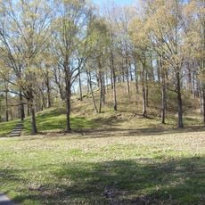
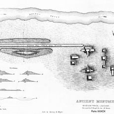
Julice Mound, Archaeological mound in East Carroll Parish, Louisiana, US

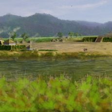
Julice Mound is an earthen platform built in East Carroll Parish in Louisiana as part of ancient settlement patterns in the region. The structure originally covered a larger area before modern development altered its form and size.

The site originated between the 13th and 16th centuries as part of the Mississippian cultural period in Northeast Louisiana. Groups constructed these mounds for ceremonial purposes and to serve as burial places for community members.

This mound served as a burial ground for the people who lived in the region, with graves positioned across its earthen surface. The site reflects how communities used elevated areas as sacred spaces for their deceased.

The mound sits in a rural area and is most easily reached by vehicle from nearby highways in the region. Visitors should verify access conditions beforehand, as the site may be on private land or have seasonal restrictions.

Modern highway construction significantly reshaped and reduced the original mound, making it a striking example of how development has altered ancient sites. This physical change serves as a visible reminder of how contemporary human activity transforms the landscape.

The community of curious travelers

AroundUs brings together thousands of curated places, local tips, and hidden gems, enriched daily by 60,000 contributors worldwide.

Start exploring
Location
GPS coordinates
32.68880,-91.21730
Latest update
December 14, 2025 13:03
Around this place
Poverty Point
United States of America

Poverty Point

19.1 km
USS Cairo
United States of America

USS Cairo

47.9 km
Mount Holly
United States of America

Mount Holly

48.3 km
Poverty Point Reservoir State Park
United States of America

Poverty Point Reservoir State Park

34.7 km
Delta National Forest
United States of America

Delta National Forest

39.5 km
Anchuca
United States of America

Anchuca

49 km
United States of America

5th United States Colored Heavy Artillery Regiment

29.8 km
Old Warren County Courthouse
United States of America

Old Warren County Courthouse

49.1 km
Fitzhugh Mounds
United States of America

Fitzhugh Mounds

42.9 km
High Delta Safari Park
United States of America

High Delta Safari Park

31.2 km
Crescent Plantation
United States of America

Crescent Plantation

36 km
Lower Mississippi River Museum
United States of America

Lower Mississippi River Museum

48.8 km
Junius R. Ward House
United States of America

Junius R. Ward House

48.8 km
Hermione
United States of America

Hermione

31.2 km
Scottland Plantation House
United States of America

Scottland Plantation House

32 km
Montrose Plantation House
United States of America

Montrose Plantation House

41.3 km
Fiske Theatre
United States of America

Fiske Theatre

24.9 km
First Baptist Church
United States of America

First Baptist Church

44.9 km
Louisiana State Cotton Museum
United States of America

Louisiana State Cotton Museum

14.4 km
Raffman Site
United States of America

Raffman Site

26.9 km
Madison Parish Courthouse
United States of America

Madison Parish Courthouse

31.4 km
American Legion Post No. 127 Building
United States of America

American Legion Post No. 127 Building

47.1 km
Planters Hall
United States of America

Planters Hall

48.9 km
Eudora City Hall
United States of America

Eudora City Hall

47.1 km
Dr. A.G. Anderson House
United States of America

Dr. A.G. Anderson House

47 km
Lake Providence Commercial Historic District
United States of America

Lake Providence Commercial Historic District

13.6 km
Kings Crossing Site
United States of America

Kings Crossing Site

47.3 km
Main Street Historic District
United States of America

Main Street Historic District

49.2 km
Show the full map
« Julice Mound - Archaeological mound in East Carroll Parish, Louisiana, US » is provided by Around Us (aroundus.com). Images and texts are derived from Wikimedia project under a Creative Commons license. You are allowed to copy, distribute, and modify copies of this page, under the conditions set by the license, as long as this note is clearly visible.

Discover hidden gems everywhere you go!

From secret cafés to breathtaking viewpoints, skip the crowded tourist spots and find places that match your style. Our app makes it easy with voice search, smart filtering, route optimization, and insider tips from travelers worldwide. Download now for the complete mobile experience.

Around Us App Screenshot

A unique approach to discovering new places

Le Figaro

All the places worth exploring

France Info

A tailor-made excursion in just a few clicks

20 Minutes

Around Us
Travel Guide & Maps
Download

Send to your phone

QR Code
1

Open the camera app on your mobile.

2

Point at the QR code with your camera. A notification will appear.

3

Tap the notification to open the link.