Enable Location

We need your location to show you interesting places around you

Discover nearby places

Find interesting locations and hidden gems around you

Precise directions

Get accurate directions and distances to places

Your location is never shared with other users. It's only used when you tap the location button.

Winter Quarters State Historic Site

Log in to your account

Start exploring — it's free

Trusted by 62,466 travelers worldwide

Continue with Google
Continue with Apple
or

We will send you a code to connect

By continuing, you accept our Terms and Conditions and our Privacy Policy

Check your inbox

We've sent a pincode in your inbox. Please enter the code below.

Winter Quarters State Historic Site

Winter Quarters State Historic Site, human settlement in Tensas Parish, Louisiana, United States of America

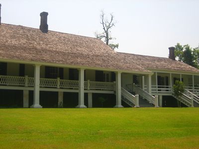
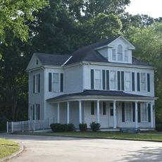
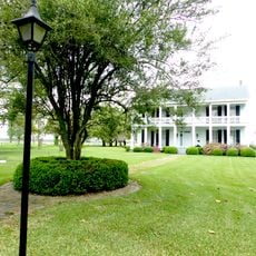
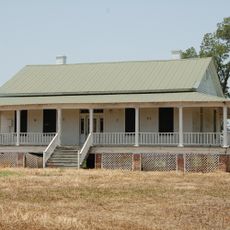
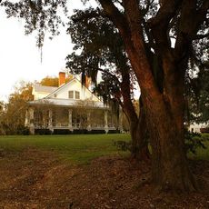
Winter Quarters State Historic Site is a plantation in Tensas Parish on a river bend. The main house started as a small hunting lodge around 1805 and grew into a residence over time, with the estate covering roughly seven acres.

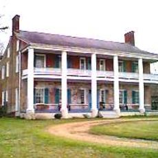
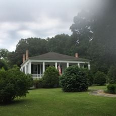
Job Routh built the original hunting house in 1805, which was later taken over by the Nutt family. During the Civil War from 1863-1864, the house remained intact because the wife of the then-owner supported the Union, while other nearby plantations were destroyed.

The name Winter Quarters comes from when people only occupied the estate during colder months. The house shows how plantation owners and their families lived and spent their time in this rural region.

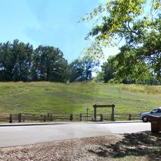
The grounds were heavily damaged by a tornado in 2011 and are currently not open to the public. The state has not announced a timeline for reopening yet.

During the Civil War, the house was the only plantation building on Lake Saint Joseph that was spared and served as a command center for Union officers. The later residents in the 1950s included a family member who became nationally known in the polio prevention movement.

The community of curious travelers

AroundUs brings together thousands of curated places, local tips, and hidden gems, enriched daily by 60,000 contributors worldwide.

Start exploring
Location
GPS coordinates
32.01288,-91.17610
Latest update
February 9, 2026 08:23
Around this place
Vicksburg Bridge
United States of America

Vicksburg Bridge

42.1 km
Old Vicksburg Bridge
United States of America

Old Vicksburg Bridge

42.2 km
Emerald Mound Site
United States of America

Emerald Mound Site

42.5 km
Chamberlain-Hunt Academy
United States of America

Chamberlain-Hunt Academy

19.4 km
Springfield Plantation
United States of America

Springfield Plantation

29.7 km
Anna Site
United States of America

Anna Site

39 km
Mangum Mound Site
United States of America

Mangum Mound Site

26.2 km
Fitzhugh Mounds
United States of America

Fitzhugh Mounds

35.4 km
Oakland Memorial Chapel
United States of America

Oakland Memorial Chapel

15.6 km
Van Dorn House
United States of America

Van Dorn House

15.4 km
Grand Gulf Military State Park
United States of America

Grand Gulf Military State Park

12.3 km
Crescent Plantation
United States of America

Crescent Plantation

39.6 km
Sacred Heart Roman Catholic Church
United States of America

Sacred Heart Roman Catholic Church

11.8 km
Gemiluth Chessed
United States of America

Gemiluth Chessed

19.2 km
Rodney Presbyterian Church
United States of America

Rodney Presbyterian Church

16.9 km
Christ Church
United States of America

Christ Church

33.7 km
Linwood Plantation Manager's House
United States of America

Linwood Plantation Manager's House

1.7 km
Bethel Presbyterian Church
United States of America

Bethel Presbyterian Church

12.7 km
Alcorn State University Historic District
United States of America

Alcorn State University Historic District

15.5 km
Montrose Plantation House
United States of America

Montrose Plantation House

34.8 km
Canemount
United States of America

Canemount

14 km
Yokena Presbyterian Church
United States of America

Yokena Presbyterian Church

28.4 km
Waterproof High School
United States of America

Waterproof High School

29.7 km
Idlewild
United States of America

Idlewild

19.2 km
Tensas Parish Courthouse
United States of America

Tensas Parish Courthouse

12.4 km
St. Joseph Historic District
United States of America

St. Joseph Historic District

12.2 km
Lake Bruin State Park
United States of America

Lake Bruin State Park

6.3 km
Trace Theater
United States of America

Trace Theater

19 km
Show the full map
« Winter Quarters State Historic Site - human settlement in Tensas Parish, Louisiana, United States of America » is provided by Around Us (aroundus.com). Images and texts are derived from Wikimedia project under a Creative Commons license. You are allowed to copy, distribute, and modify copies of this page, under the conditions set by the license, as long as this note is clearly visible.

Discover hidden gems everywhere you go!

From secret cafés to breathtaking viewpoints, skip the crowded tourist spots and find places that match your style. Our app makes it easy with voice search, smart filtering, route optimization, and insider tips from travelers worldwide. Download now for the complete mobile experience.

Around Us App Screenshot

A unique approach to discovering new places

Le Figaro

All the places worth exploring

France Info

A tailor-made excursion in just a few clicks

20 Minutes

Around Us
Travel Guide & Maps
Download

Send to your phone

QR Code
1

Open the camera app on your mobile.

2

Point at the QR code with your camera. A notification will appear.

3

Tap the notification to open the link.