Enable Location

We need your location to show you interesting places around you

Discover nearby places

Find interesting locations and hidden gems around you

Precise directions

Get accurate directions and distances to places

Your location is never shared with other users. It's only used when you tap the location button.

Log in to your account

Start exploring — it's free

Trusted by 67,499 travelers worldwide

Continue with Google
Continue with Apple
or

We will send you a code to connect

By continuing, you accept our Terms and Conditions and our Privacy Policy

Check your inbox

We've sent a pincode in your inbox. Please enter the code below.

DeQueen Lake
Discussion Reviews Photo
1.4k Popularity

DeQueen Lake, body of water

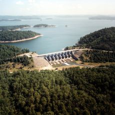
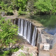
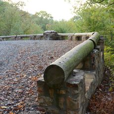
DeQueen Lake is a reservoir along the Rolling Fork River in Sevier County, Arkansas, located about four miles from the town of DeQueen. The water is held back by an earth dam roughly 160 feet (49 meters) tall, and the lake is flanked by three campgrounds, six boat ramps, and three designated swimming areas.

The reservoir was created following the Flood Control Act of 1958, with construction beginning in April 1966 under supervision of the Tulsa District of the United States Army Corps of Engineers. The lake officially became operational on August 31, 1977, and has since served flood control and water supply purposes for the region.

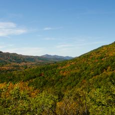
The lake takes its name from the nearby town of DeQueen, which shaped the identity of the region. It serves as a gathering place where locals and visitors spend time with family and friends, sharing meals and relaxation by the water.

The lake is easy to access, with entry points at six different boat ramps and designated parking near the campgrounds and picnic areas. Visitors should know that activities are possible year-round, with summer being busiest, while cooler months tend to be quieter and better suited for hiking.

The entire shoreline of DeQueen Lake is publicly owned, allowing boaters to land anywhere along the many beaches and grassy areas. This unusual feature gives visitors the freedom to explore the lake's edges without restrictions.

The community of curious travelers

AroundUs brings together thousands of curated places, local tips, and hidden gems, enriched daily by 60,000 contributors worldwide.

Start exploring
Location
GPS coordinates
34.11350,-94.38900
Latest update
February 9, 2026 08:18
Around this place
Broken Bow Lake
United States of America

Broken Bow Lake

28.6 km
Beavers Bend Resort Park
United States of America

Beavers Bend Resort Park

27.8 km
Cossatot River State Park-Natural Area
United States of America

Cossatot River State Park-Natural Area

28.7 km
Little River National Wildlife Refuge
United States of America

Little River National Wildlife Refuge

40 km
Shady Lake Recreation Area
United States of America

Shady Lake Recreation Area

43 km
Ebenezer Campground
United States of America

Ebenezer Campground

39.5 km
St. Barnabas Episcopal Church
United States of America

St. Barnabas Episcopal Church

42.6 km
Mountain Fork Bridge
United States of America

Mountain Fork Bridge

46.2 km
Bard Springs Bathhouse
United States of America

Bard Springs Bathhouse

46.5 km
Tall Peak Fire Tower
United States of America

Tall Peak Fire Tower

44 km
Oak Grove Rosenwald School
United States of America

Oak Grove Rosenwald School

34.6 km
Little Cossatot River Bridge
United States of America

Little Cossatot River Bridge

23 km
Hale Creek Bridge
United States of America

Hale Creek Bridge

19.1 km
First United Methodist Church
United States of America

First United Methodist Church

26.2 km
Idabel Armory
United States of America

Idabel Armory

46.7 km
DeQueen Commercial Historic District
United States of America

DeQueen Commercial Historic District

9.6 km
Hawkins House
United States of America

Hawkins House

43.5 km
Hayes Hardware Store
United States of America

Hayes Hardware Store

9.5 km
First Presbyterian Church
United States of America

First Presbyterian Church

9.2 km
Bishop Brookes House
United States of America

Bishop Brookes House

9.2 km
Buckeye Vista Overlook
United States of America

Buckeye Vista Overlook

46.7 km
Sugar Creek Vista Overlook
United States of America

Sugar Creek Vista Overlook

46.6 km
Otis Theodore and Effiegene Locke Wingo House
United States of America

Otis Theodore and Effiegene Locke Wingo House

9.2 km
New Rocky Comfort Jail
United States of America

New Rocky Comfort Jail

43.5 km
S.S.P. Mills and Son Building
United States of America

S.S.P. Mills and Son Building

47.1 km
Gillham City Jail
United States of America

Gillham City Jail

9.2 km
King Schoolhouse
United States of America

King Schoolhouse

9.1 km
Lockesburg Waterworks
United States of America

Lockesburg Waterworks

26.1 km
Show the full map
Reviews
Share your experience

No review yet

Discussions
Start a discussion...

No discussion yet

« DeQueen Lake - body of water » is provided by Around Us (aroundus.com). Images and texts are derived from Wikimedia project under a Creative Commons license. You are allowed to copy, distribute, and modify copies of this page, under the conditions set by the license, as long as this note is clearly visible.

Discover hidden gems everywhere you go!

From secret cafés to breathtaking viewpoints, skip the crowded tourist spots and find places that match your style. Our app makes it easy with voice search, smart filtering, route optimization, and insider tips from travelers worldwide. Download now for the complete mobile experience.

Around Us App Screenshot

A unique approach to discovering new places

Le Figaro

All the places worth exploring

France Info

A tailor-made excursion in just a few clicks

20 Minutes

Around Us
Travel Guide & Maps
Download

Send to your phone

QR Code
1

Open the camera app on your mobile.

2

Point at the QR code with your camera. A notification will appear.

3

Tap the notification to open the link.