Chest opened
+${chestReward.xp} XP
Explorer
NOUVEAU ×${chestReward.collectible.quantity}
tapez pour fermer
Chest locked

Open chests in the app

Around Us is built for your phone — chests unlock when you walk, explore and capture nearby places.

Enable Location

We need your location to show you interesting places around you

Discover nearby places

Find interesting locations and hidden gems around you

Precise directions

Get accurate directions and distances to places

Your location is never shared with other users. It's only used when you tap the location button.

Log in to your account

Start exploring — it's free

Trusted by 72,889 travelers worldwide

Continue with Google
Continue with Apple
or

We will send you a code to connect

By continuing, you accept our Terms and Conditions and our Privacy Policy

Check your inbox

We've sent a pincode in your inbox. Please enter the code below.

Rice Belt
Discussion Reviews Photo
18.1k Popularity

Rice Belt, Agricultural region in eastern Mississippi, United States.

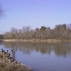
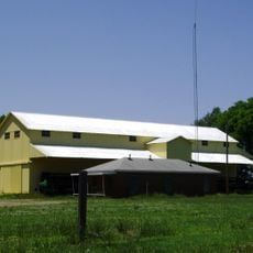
The Rice Belt is an agricultural region spanning four states and defined by rice farming as its primary industry. The landscape consists of flat fields with irrigated crop areas, supported by humid conditions and fertile soils suitable for this crop.

Commercial rice farming in this region began in the 1940s, initially concentrated in the Mississippi-Yazoo Delta area. Since then, it has grown into the largest rice-producing area in the United States.

Rice farming remains central to how local communities see themselves and organize their seasonal rhythms. Visitors walking through the region witness landscapes shaped entirely by this agricultural tradition.

The region is best explored during the growing season when fields are actively cultivated and show the most activity. Flat terrain and open spaces offer good views, though the climate can be hot and humid.

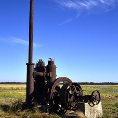
The region relies on sophisticated irrigation systems that precisely manage water levels to support rice growth. This infrastructure shapes the visible landscape with channels and pumping stations throughout the fields.

The community of curious travelers

AroundUs brings together thousands of curated places, local tips, and hidden gems, enriched daily by 60,000 contributors worldwide.

Start exploring
Location
Location
Location
Location
GPS coordinates
34.00000,-91.00000
Latest update
March 5, 2026 18:16
Around this place
Mississippi Alluvial Plain
United States of America

Mississippi Alluvial Plain

0 m
Arkansas Post
United States of America

Arkansas Post

31.9 km
Ground Zero
United States of America

Ground Zero

45.1 km
Delta Blues Museum
United States of America

Delta Blues Museum

45.2 km
Grammy Museum Mississippi
United States of America

Grammy Museum Mississippi

37.5 km
Menard-Hodges Site
United States of America

Menard-Hodges Site

23.5 km
Yancopin Bridge
United States of America

Yancopin Bridge

19.7 km
I. T. Montgomery House
United States of America

I. T. Montgomery House

28.5 km
Hollywood
United States of America

Hollywood

40.1 km
Great River Road State Park
United States of America

Great River Road State Park

18.1 km
Temple Adath Israel
United States of America

Temple Adath Israel

38.3 km
St. Charles Battle Monument
United States of America

St. Charles Battle Monument

43.5 km
Arkansas County Courthouse-Southern District
United States of America

Arkansas County Courthouse-Southern District

45.1 km
St. Charles Battle Site
United States of America

St. Charles Battle Site

43.7 km
Halliburton House
United States of America

Halliburton House

45.5 km
A.M. Bohnert Rice Plantation Pump
United States of America

A.M. Bohnert Rice Plantation Pump

34.8 km
Grace Episcopal Church
United States of America

Grace Episcopal Church

16.2 km
L.A. Black Rice Milling Association Inc. Office
United States of America

L.A. Black Rice Milling Association Inc. Office

45.1 km
Warrens Bridge
United States of America

Warrens Bridge

37.4 km
North Washington Street Bridge
United States of America

North Washington Street Bridge

45.4 km
First United Methodist Church
United States of America

First United Methodist Church

45.2 km
DeWitt Commercial Historic District
United States of America

DeWitt Commercial Historic District

45 km
Maxwell Street Bridge
United States of America

Maxwell Street Bridge

45.4 km
Kemp Cotton Gin Historic District
United States of America

Kemp Cotton Gin Historic District

36.7 km
Harmony Bowling
United States of America

Harmony Bowling

36.7 km
Arkansas Post National Memorial Visitor Center and Museum
United States of America

Arkansas Post National Memorial Visitor Center and Museum

31.9 km
Delta Cinema
United States of America

Delta Cinema

45.1 km
Rohwer Relocation Center Memorial Cemetery
United States of America

Rohwer Relocation Center Memorial Cemetery

36.7 km
Show the full map
Reviews
Share your experience

No review yet

Discussions
Start a discussion...

No discussion yet

« Rice Belt - Agricultural region in eastern Mississippi, United States » is provided by Around Us (aroundus.com). Images and texts are derived from Wikimedia project under a Creative Commons license. You are allowed to copy, distribute, and modify copies of this page, under the conditions set by the license, as long as this note is clearly visible.

Discover hidden gems everywhere you go!

From secret cafés to breathtaking viewpoints, skip the crowded tourist spots and find places that match your style. Our app makes it easy with voice search, smart filtering, route optimization, and insider tips from travelers worldwide. Download now for the complete mobile experience.

Around Us App Screenshot

A unique approach to discovering new places

Le Figaro

All the places worth exploring

France Info

A tailor-made excursion in just a few clicks

20 Minutes

Around Us
Travel Guide & Maps
Download

Send to your phone

QR Code
1

Open the camera app on your mobile.

2

Point at the QR code with your camera. A notification will appear.

3

Tap the notification to open the link.