Enable Location

We need your location to show you interesting places around you

Discover nearby places

Find interesting locations and hidden gems around you

Precise directions

Get accurate directions and distances to places

Your location is never shared with other users. It's only used when you tap the location button.

Nectar Covered Bridge

Log in to your account

Start exploring — it's free

Trusted by 61,886 travelers worldwide

Continue with Google
Continue with Apple
or

We will send you a code to connect

By continuing, you accept our Terms and Conditions and our Privacy Policy

Check your inbox

We've sent a pincode in your inbox. Please enter the code below.

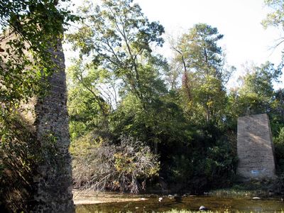
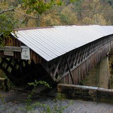
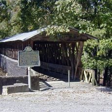
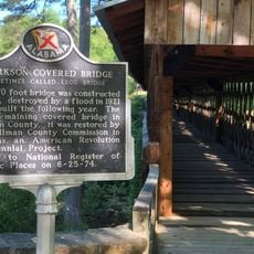
Nectar Covered Bridge, Covered bridge ruins in Nectar, Alabama, United States.

Nectar Covered Bridge was a wooden bridge that crossed the Locust Fork of the Black Warrior River using a lattice truss design. The structure spanned approximately 385 feet and supported traffic with four main support sections across the water.

The crossing was constructed in 1934 under the direction of foreman Zelma C. Tidwell and served regional traffic for decades. Fire destroyed the structure in 1993, leaving only stone piers and foundation remains visible today at the site.

The bridge served as a gathering place where the community came together for local celebrations and everyday interactions. This crossing held social importance as a vital link connecting the settlements on both sides of the river.

The site is located near State Route 160 and can be viewed from the modern concrete bridge built north of the original crossing. The ruins are easily accessible, though visitors should watch for uneven stone piers and stay cautious near the riverbank.

Before its destruction, this crossing ranked among the longest covered bridges in the nation, making its loss particularly significant. The deliberate fire that burned it down was a dramatic turning point in the bridge's story.

The community of curious travelers

AroundUs brings together thousands of curated places, local tips, and hidden gems, enriched daily by 60,000 contributors worldwide.

Start exploring
Location
Inception
1928
GPS coordinates
33.95624,-86.62616
Latest update
December 14, 2025 12:22
Around this place
Barber Motorsports Park
United States of America

Barber Motorsports Park

47.2 km
Church of the Highlands
United States of America

Church of the Highlands

49 km
Ave Maria Grotto
United States of America

Ave Maria Grotto

30 km
Southern Museum of Flight
United States of America

Southern Museum of Flight

44.9 km
Rickwood Caverns State Park
United States of America

Rickwood Caverns State Park

21.9 km
Swann Covered Bridge
United States of America

Swann Covered Bridge

5.1 km
Horton Mill Covered Bridge
United States of America

Horton Mill Covered Bridge

17.4 km
Birmingham Alabama Temple
United States of America

Birmingham Alabama Temple

36.2 km
Easley Covered Bridge
United States of America

Easley Covered Bridge

10.1 km
John Looney House
United States of America

John Looney House

42.8 km
Clarkson–Legg Covered Bridge
United States of America

Clarkson–Legg Covered Bridge

43.7 km
Barber Motorsports Park
United States of America

Barber Motorsports Park

47.1 km
Cullman Historic District
United States of America

Cullman Historic District

30.8 km
Ernest Edward Greene House
United States of America

Ernest Edward Greene House

31.6 km
Stiefelmeyer's
United States of America

Stiefelmeyer's

31.6 km
Robert G. Griffith, Sr. House
United States of America

Robert G. Griffith, Sr. House

31.5 km
Crane Hill Masonic Lodge
United States of America

Crane Hill Masonic Lodge

41.6 km
Cullman Downtown Commercial Historic District
United States of America

Cullman Downtown Commercial Historic District

31.4 km
Barber Vintage Motorsports Museum
United States of America

Barber Vintage Motorsports Museum

47.1 km
Springville Historic District
United States of America

Springville Historic District

24.7 km
Clarkson Covered Bridge
United States of America

Clarkson Covered Bridge

43.7 km
Ashville Historic District
United States of America

Ashville Historic District

37 km
Dr. James J. Bothwell House
United States of America

Dr. James J. Bothwell House

36.9 km
Attalla Downtown Historic District
United States of America

Attalla Downtown Historic District

50.1 km
Judge Elisha Robinson House
United States of America

Judge Elisha Robinson House

36.8 km
Baileyton Good Time DragStrip
United States of America

Baileyton Good Time DragStrip

32.4 km
Irondale Train Watching Platform
United States of America

Irondale Train Watching Platform

47.1 km
Norwood Historic District
United States of America

Norwood Historic District

49.1 km
Show the full map
« Nectar Covered Bridge - Covered bridge ruins in Nectar, Alabama, United States » is provided by Around Us (aroundus.com). Images and texts are derived from Wikimedia project under a Creative Commons license. You are allowed to copy, distribute, and modify copies of this page, under the conditions set by the license, as long as this note is clearly visible.

Discover hidden gems everywhere you go!

From secret cafés to breathtaking viewpoints, skip the crowded tourist spots and find places that match your style. Our app makes it easy with voice search, smart filtering, route optimization, and insider tips from travelers worldwide. Download now for the complete mobile experience.

Around Us App Screenshot

A unique approach to discovering new places

Le Figaro

All the places worth exploring

France Info

A tailor-made excursion in just a few clicks

20 Minutes

Around Us
Travel Guide & Maps
Download

Send to your phone

QR Code
1

Open the camera app on your mobile.

2

Point at the QR code with your camera. A notification will appear.

3

Tap the notification to open the link.