Clarkson Covered Bridge

Log in to your account

AroundUs is a community-driven map of interesting places, built by curious explorers like you. It grows with every review, story, and photo you share.
Connect to save your favorite spots, contribute locations, and create personalized routes.
Continue with Google
Continue with Apple
Continue with X
Continue with Facebook
Continue with email
By continuing, you accept our Terms and Conditions and our Privacy Policy
Create an account
Add to collection
Map
Suggest a change
Share

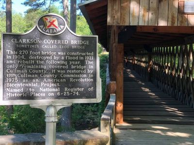
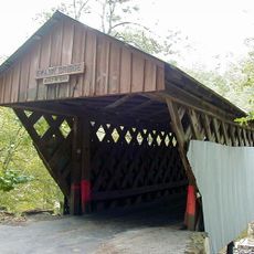
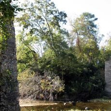
Clarkson Covered Bridge, Wooden covered bridge in Bethel, Alabama.

Clarkson Covered Bridge is a wooden structure spanning Crooked Creek in Alabama, built using the Town lattice truss design with interlocking wooden beams. This method of construction creates a strong framework that has kept the bridge standing and functional for more than a century.

Built in the early 1900s by a local mail carrier, the structure suffered major damage from flooding and was rebuilt in the following decades. This repair showed how important the bridge was to the community and its determination to maintain this crossing.

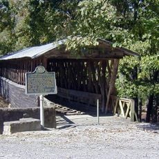
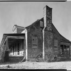
The bridge serves as the heart of a park that includes a historic grist mill and a dogtrot log cabin, both showing how people built and lived in this region. Walking through the site gives a sense of rural life and the skills needed to work with wood and water.

The site sits in a public park setting that is easy to reach during daylight hours, with parking available and space to walk around. Comfortable shoes are recommended since you will want to explore the bridge, the mill, and the log cabin on foot.

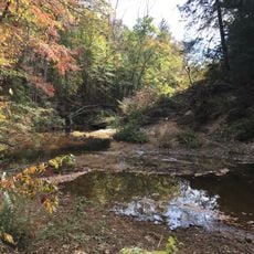
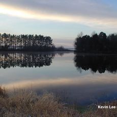
The park area was caught in military conflict during the 1860s when opposing forces clashed near the crossing. This chapter of local history often goes unnoticed by visitors but shaped how people remember the bridge today.

Location: Cullman County

Address: 1240 Co Rd 1043, Cullman, AL 35057, USA

Opening Hours: Monday-Sunday 07:00-19:00

Phone: +12567392916

Website: http://cullmancountyparks.com/clarkson.html

GPS coordinates: 34.20717,-86.99044

Latest update: December 9, 2025 20:28

Photos
Around this place
Sipsey Wilderness
United States of America

Sipsey Wilderness

44.4 km
William B. Bankhead National Forest
United States of America

William B. Bankhead National Forest

40.4 km
Ave Maria Grotto
United States of America

Ave Maria Grotto

16.4 km
Wheeler National Wildlife Refuge
United States of America

Wheeler National Wildlife Refuge

39.2 km
Rickwood Caverns State Park
United States of America

Rickwood Caverns State Park

38.9 km
Swann Covered Bridge
United States of America

Swann Covered Bridge

42.8 km
Clarkson–Legg Covered Bridge
United States of America

Clarkson–Legg Covered Bridge

59 m
Princess Theatre
United States of America

Princess Theatre

44.2 km
Nectar Covered Bridge
United States of America

Nectar Covered Bridge

43.7 km
Newsome Sinks Karst Area
United States of America

Newsome Sinks Karst Area

44.5 km
Winston County Courthouse
United States of America

Winston County Courthouse

38.5 km
Cotaco Opera House
United States of America

Cotaco Opera House

44 km
Cullman Historic District
United States of America

Cullman Historic District

15 km
Ernest Edward Greene House
United States of America

Ernest Edward Greene House

14.4 km
Westview Plantation
United States of America

Westview Plantation

32.9 km
Ice House
United States of America

Ice House

41.2 km
Stiefelmeyer's
United States of America

Stiefelmeyer's

14.1 km
Crane Hill Masonic Lodge
United States of America

Crane Hill Masonic Lodge

13.2 km
Cullman Downtown Commercial Historic District
United States of America

Cullman Downtown Commercial Historic District

14.3 km
Somerville Courthouse
United States of America

Somerville Courthouse

34.8 km
New Decatur–Albany Historic District
United States of America

New Decatur–Albany Historic District

44.1 km
Moulton Courthouse Square Historic District
United States of America

Moulton Courthouse Square Historic District

41.2 km
Green Pryor Rice House
United States of America

Green Pryor Rice House

34.7 km
Hartselle Downtown Commercial Historic District
United States of America

Hartselle Downtown Commercial Historic District

26.8 km
Baileyton Good Time DragStrip
United States of America

Baileyton Good Time DragStrip

35.4 km
Ogle Stadium
United States of America

Ogle Stadium

42.9 km
Historic Downtown Hartselle
United States of America

Historic Downtown Hartselle

26.9 km
Albany Heritage Neighborhood Historic District
United States of America

Albany Heritage Neighborhood Historic District

43.9 km
Show the full map
Reviews

Visited this place? Tap the stars to rate it and share your experience / photos with the community! Try now! You can cancel it anytime.

« Clarkson Covered Bridge - Wooden covered bridge in Bethel, Alabama » is provided by Around Us (aroundus.com). Images and texts are derived from Wikimedia project under a Creative Commons license. You are allowed to copy, distribute, and modify copies of this page, under the conditions set by the license, as long as this note is clearly visible.

Discover hidden gems everywhere you go!

From secret cafés to breathtaking viewpoints, skip the crowded tourist spots and find places that match your style. Our app makes it easy with voice search, smart filtering, route optimization, and insider tips from travelers worldwide. Download now for the complete mobile experience.

Around Us App Screenshot

A unique approach to discovering new places

Le Figaro

All the places worth exploring

France Info

A tailor-made excursion in just a few clicks

20 Minutes