Enable Location

We need your location to show you interesting places around you

Discover nearby places

Find interesting locations and hidden gems around you

Precise directions

Get accurate directions and distances to places

Your location is never shared with other users. It's only used when you tap the location button.

Swann Covered Bridge

Log in to your account

Start exploring — it's free

Trusted by 61,888 travelers worldwide

Continue with Google
Continue with Apple
or

We will send you a code to connect

By continuing, you accept our Terms and Conditions and our Privacy Policy

Check your inbox

We've sent a pincode in your inbox. Please enter the code below.

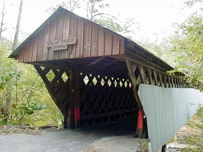
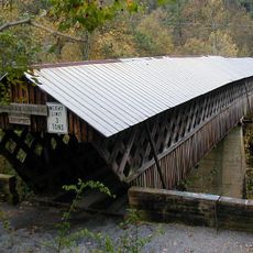
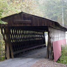
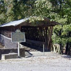
Swann Covered Bridge, Covered bridge in Cleveland, Alabama

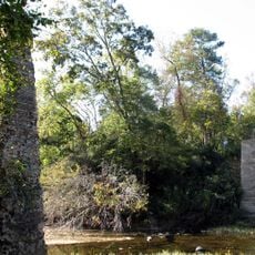
Swann Covered Bridge is a wooden river crossing in Blount County that spans the Locust Fork of the Black Warrior River with three sections. It uses a lattice framework system that provides structural strength across the waterway.

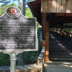
The bridge was built in 1933 to connect Cleveland with the nearby community of Joy. After a major fire destroyed another covered bridge in 1993, this one became the oldest of its kind remaining in the state.

The structure shows early 20th-century construction methods that rural engineers developed for river crossings. Walking across the wooden lattice design gives visitors a sense of how communities solved transportation challenges with simple materials.

The bridge sits on Swann Bridge Road near State Route 79 and is open to single-lane vehicle traffic. Visitors can access it year-round and should note that the structure underwent major restoration work.

After the collapse of another famous bridge in the region, this became the longest of its kind in Alabama. Today it stands as a reminder of a building method that vanished from almost everywhere else in the country.

The community of curious travelers

AroundUs brings together thousands of curated places, local tips, and hidden gems, enriched daily by 60,000 contributors worldwide.

Start exploring
Location
Inception
1933
GPS coordinates
33.99760,-86.60143
Latest update
December 11, 2025 11:08
Around this place
Ave Maria Grotto
United States of America

Ave Maria Grotto

28 km
Snead State Community College
United States of America

Snead State Community College

45.8 km
Rickwood Caverns State Park
United States of America

Rickwood Caverns State Park

26 km
Horton Mill Covered Bridge
United States of America

Horton Mill Covered Bridge

14.1 km
Birmingham Alabama Temple
United States of America

Birmingham Alabama Temple

41.3 km
Easley Covered Bridge
United States of America

Easley Covered Bridge

8.2 km
John Looney House
United States of America

John Looney House

42.6 km
Clarkson–Legg Covered Bridge
United States of America

Clarkson–Legg Covered Bridge

42.8 km
Nectar Covered Bridge
United States of America

Nectar Covered Bridge

5.1 km
Newsome Sinks Karst Area
United States of America

Newsome Sinks Karst Area

49.3 km
Cullman Historic District
United States of America

Cullman Historic District

29 km
Ernest Edward Greene House
United States of America

Ernest Edward Greene House

29.7 km
Stiefelmeyer's
United States of America

Stiefelmeyer's

29.8 km
Robert G. Griffith, Sr. House
United States of America

Robert G. Griffith, Sr. House

26.3 km
Crane Hill Masonic Lodge
United States of America

Crane Hill Masonic Lodge

42.3 km
Julia Street Memorial United Methodist Church
United States of America

Julia Street Memorial United Methodist Church

46.4 km
Cullman Downtown Commercial Historic District
United States of America

Cullman Downtown Commercial Historic District

29.6 km
Springville Historic District
United States of America

Springville Historic District

27.5 km
Clarkson Covered Bridge
United States of America

Clarkson Covered Bridge

42.8 km
Ashville Historic District
United States of America

Ashville Historic District

36.9 km
Edward Fenns Whitman House
United States of America

Edward Fenns Whitman House

46.3 km
Thomas A. Snellgrove Homestead
United States of America

Thomas A. Snellgrove Homestead

46.5 km
Dr. James J. Bothwell House
United States of America

Dr. James J. Bothwell House

36.8 km
Downtown Guntersville Historic District
United States of America

Downtown Guntersville Historic District

49.2 km
Old Rock School
United States of America

Old Rock School

48 km
Attalla Downtown Historic District
United States of America

Attalla Downtown Historic District

47.3 km
Albert G. Henry, Jr., House
United States of America

Albert G. Henry, Jr., House

49.5 km
Judge Elisha Robinson House
United States of America

Judge Elisha Robinson House

36.8 km
Show the full map
« Swann Covered Bridge - Covered bridge in Cleveland, Alabama » is provided by Around Us (aroundus.com). Images and texts are derived from Wikimedia project under a Creative Commons license. You are allowed to copy, distribute, and modify copies of this page, under the conditions set by the license, as long as this note is clearly visible.

Discover hidden gems everywhere you go!

From secret cafés to breathtaking viewpoints, skip the crowded tourist spots and find places that match your style. Our app makes it easy with voice search, smart filtering, route optimization, and insider tips from travelers worldwide. Download now for the complete mobile experience.

Around Us App Screenshot

A unique approach to discovering new places

Le Figaro

All the places worth exploring

France Info

A tailor-made excursion in just a few clicks

20 Minutes

Around Us
Travel Guide & Maps
Download

Send to your phone

QR Code
1

Open the camera app on your mobile.

2

Point at the QR code with your camera. A notification will appear.

3

Tap the notification to open the link.