Cullman County

Log in to your account

AroundUs is a community-driven map of interesting places, built by curious explorers like you. It grows with every review, story, and photo you share.
Connect to save your favorite spots, contribute locations, and create personalized routes.
Continue with Google
Continue with Apple
Continue with X
Continue with Facebook
Continue with email
By continuing, you accept our Terms and Conditions and our Privacy Policy
Create an account
Add to collection
Map
Suggest a change
Share

Cullman County, Administrative division in northern Alabama, United States.

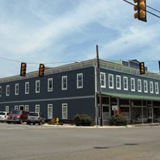
Cullman County is an administrative division in northern Alabama that straddles Interstate 65 between Birmingham and Huntsville. The region combines residential neighborhoods, farming areas, and business centers across rolling terrain.

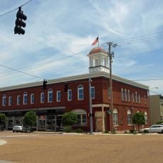
The territory was originally Cherokee land before American settlers arrived, and Colonel John G. Cullmann established a German settlement here in 1873. This founding created a major shift in how the region developed under European immigrant leadership.

German immigrant roots are woven into the community's identity since its establishment in 1873, and you can still see this heritage reflected in local celebrations, food traditions, and family names throughout the region.

The area spreads across Interstate 65, making it easy to explore by car with multiple exit points along the main highway. Most locations are best reached by personal vehicle since public transportation is limited throughout the region.

An EF4 tornado struck during the 2011 Super Outbreak, leaving lasting marks on local communities that were rebuilt afterward. This natural disaster became a defining moment in the region's collective memory and community resilience.

Location: Alabama

Inception: January 24, 1877

Capital city: Cullman

Shares border with: Morgan County, Blount County, Winston County, Lawrence County, Marshall County, Walker County

Website: http://co.cullman.al.us

GPS coordinates: 34.13333,-86.86667

Latest update: December 20, 2025 12:08

Photos
Around this place
United States of America

Lewis Smith Lake

30.6 km
Shrine of the Most Blessed Sacrament
United States of America

Shrine of the Most Blessed Sacrament

18.6 km
Ave Maria Grotto
United States of America

Ave Maria Grotto

6.6 km
Rickwood Caverns State Park
United States of America

Rickwood Caverns State Park

28.3 km
Swann Covered Bridge
United States of America

Swann Covered Bridge

28.8 km
Easley Covered Bridge
United States of America

Easley Covered Bridge

36.8 km
Clarkson–Legg Covered Bridge
United States of America

Clarkson–Legg Covered Bridge

14.1 km
Nectar Covered Bridge
United States of America

Nectar Covered Bridge

29.7 km
United States of America

Lidy Walker Covered Bridge

13.2 km
Cullman Historic District
United States of America

Cullman Historic District

5.5 km
Ernest Edward Greene House
United States of America

Ernest Edward Greene House

5.8 km
Stiefelmeyer's
United States of America

Stiefelmeyer's

5.3 km
Robert G. Griffith, Sr. House
United States of America

Robert G. Griffith, Sr. House

36.9 km
Crane Hill Masonic Lodge
United States of America

Crane Hill Masonic Lodge

16.8 km
Cullman Downtown Commercial Historic District
United States of America

Cullman Downtown Commercial Historic District

5.3 km
United States of America

Cullman County Museum

5.6 km
Clarkson Covered Bridge
United States of America

Clarkson Covered Bridge

14.1 km
United States of America

Abbaye Saint-Bernard

7 km
Baileyton Good Time DragStrip
United States of America

Baileyton Good Time DragStrip

26.9 km
United States of America

Lake Catoma

10.4 km
United States of America

Oneonta Recreation Park

40.7 km
United States of America

Scirum Bluff

28.4 km
Oneonta Aquatics Facility
United States of America

Oneonta Aquatics Facility

40.8 km
United States of America

Ingram Arkadelphia Lake

23.9 km
United States of America

Banking Grounds

33.9 km
United States of America

Hart Lake

4.7 km
United States of America

Town Square Triple Theatre

4.2 km
United States of America

Camps Lake

28.5 km
Show the full map
Reviews

Visited this place? Tap the stars to rate it and share your experience / photos with the community! Try now! You can cancel it anytime.

« Cullman County - Administrative division in northern Alabama, United States » is provided by Around Us (aroundus.com). Images and texts are derived from Wikimedia project under a Creative Commons license. You are allowed to copy, distribute, and modify copies of this page, under the conditions set by the license, as long as this note is clearly visible.

Discover hidden gems everywhere you go!

From secret cafés to breathtaking viewpoints, skip the crowded tourist spots and find places that match your style. Our app makes it easy with voice search, smart filtering, route optimization, and insider tips from travelers worldwide. Download now for the complete mobile experience.

Around Us App Screenshot

A unique approach to discovering new places

Le Figaro

All the places worth exploring

France Info

A tailor-made excursion in just a few clicks

20 Minutes