Enable Location

We need your location to show you interesting places around you

Discover nearby places

Find interesting locations and hidden gems around you

Precise directions

Get accurate directions and distances to places

Your location is never shared with other users. It's only used when you tap the location button.

Log in to your account

Start exploring — it's free

Trusted by 63,380 travelers worldwide

Continue with Google
Continue with Apple
or

We will send you a code to connect

By continuing, you accept our Terms and Conditions and our Privacy Policy

Check your inbox

We've sent a pincode in your inbox. Please enter the code below.

Discussion Reviews Photo
20.3k Popularity

Crowley, city in Tarrant County, Texas, United States

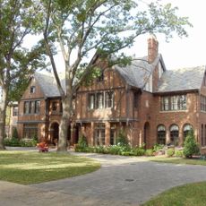
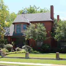
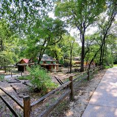
Crowley is a city in Texas located at the border between Tarrant and Johnson counties. It spreads across residential neighborhoods, small commercial areas, and parks, with newer developments like Karis offering green spaces and walking trails.

Crowley began as a farming settlement called Deer Creek around 1848 and took its current name in 1952. The arrival of the railroad in 1885, with its first depot station, marked a turning point in the community's growth.

The city is named after S.H. Crowley, a key figure in the area's transportation development. Residents gather at local festivals and community events that celebrate shared traditions and neighborhood bonds.

The city sits about 15 miles south of Fort Worth and is easily reached by car. Major highways like Interstate 35 and Interstate 20 connect it to larger cities and DFW International Airport.

The Karis development represents a thoughtful approach to modern planning, with intentional walkways and green spaces that blend traditional small-town living with contemporary design. These neighborhoods show how the city is shaping its future growth.

The community of curious travelers

AroundUs brings together thousands of curated places, local tips, and hidden gems, enriched daily by 60,000 contributors worldwide.

Start exploring
Location
Location
Inception
1951
Elevation above the sea
237 m
Shares border with
Edgecliff Village
GPS coordinates
32.57690,-97.35970
Latest update
February 16, 2026 21:40
Around this place
Amon G. Carter Stadium
United States of America

Amon G. Carter Stadium

14.8 km
Colonial Country Club
United States of America

Colonial Country Club

15.9 km
R. L. Paschal High School
United States of America

R. L. Paschal High School

14.6 km
National Cowgirl Museum and Hall of Fame
United States of America

National Cowgirl Museum and Hall of Fame

18.5 km
Fort Worth Botanic Garden
United States of America

Fort Worth Botanic Garden

18 km
Lupton Stadium
United States of America

Lupton Stadium

14.1 km
Fort Worth Japanese Garden
United States of America

Fort Worth Japanese Garden

17.6 km
Fort Worth Museum of Science and History
United States of America

Fort Worth Museum of Science and History

18.6 km
Wharton-Scott House
United States of America

Wharton-Scott House

18 km
Botanical Research Institute of Texas
United States of America

Botanical Research Institute of Texas

18.4 km
Carruthers Field
United States of America

Carruthers Field

14.7 km
Fairmount-Southside Historic District
United States of America

Fairmount-Southside Historic District

16.6 km
Ridglea Theatre
United States of America

Ridglea Theatre

17.7 km
United States Post Office
United States of America

United States Post Office

17.3 km
St. Mary of the Assumption Church
United States of America

St. Mary of the Assumption Church

17.3 km
M. A. Benton House
United States of America

M. A. Benton House

16.7 km
Montgomery Street Antique Mall

Montgomery Street Antique Mall

17.5 km
Our Lady of Victory Academy
United States of America

Our Lady of Victory Academy

14.1 km
Our Mother of Mercy Catholic Church and Parsonage
United States of America

Our Mother of Mercy Catholic Church and Parsonage

17.8 km
Roy A. and Gladys Westbrook House
United States of America

Roy A. and Gladys Westbrook House

16 km
Marshall R. Sanguinet House
United States of America

Marshall R. Sanguinet House

18.1 km
South Side Masonic Lodge No. 1114
United States of America

South Side Masonic Lodge No. 1114

17.2 km
Log Cabin Village

Log Cabin Village

16 km
Lost Oak Winery

Lost Oak Winery

8.9 km
Marty Leonard Community Chapel at Lina Popoe Home
United States of America

Marty Leonard Community Chapel at Lina Popoe Home

17.3 km
The Clearfork Farmers Market

The Clearfork Farmers Market

14.9 km
Movie Tavern
United States of America

Movie Tavern

11.9 km
Classic Wine

Classic Wine

15.1 km
Show the full map
Reviews
Share your experience

No review yet

Discussions
Start a discussion...

No discussion yet

« Crowley - city in Tarrant County, Texas, United States » is provided by Around Us (aroundus.com). Images and texts are derived from Wikimedia project under a Creative Commons license. You are allowed to copy, distribute, and modify copies of this page, under the conditions set by the license, as long as this note is clearly visible.

Discover hidden gems everywhere you go!

From secret cafés to breathtaking viewpoints, skip the crowded tourist spots and find places that match your style. Our app makes it easy with voice search, smart filtering, route optimization, and insider tips from travelers worldwide. Download now for the complete mobile experience.

Around Us App Screenshot

A unique approach to discovering new places

Le Figaro

All the places worth exploring

France Info

A tailor-made excursion in just a few clicks

20 Minutes

Around Us
Travel Guide & Maps
Download

Send to your phone

QR Code
1

Open the camera app on your mobile.

2

Point at the QR code with your camera. A notification will appear.

3

Tap the notification to open the link.