Enable Location

We need your location to show you interesting places around you

Discover nearby places

Find interesting locations and hidden gems around you

Precise directions

Get accurate directions and distances to places

Your location is never shared with other users. It's only used when you tap the location button.

Blackburn Point Bridge

Log in to your account

Start exploring — it's free

Trusted by 62,171 travelers worldwide

Continue with Google
Continue with Apple
or

We will send you a code to connect

By continuing, you accept our Terms and Conditions and our Privacy Policy

Check your inbox

We've sent a pincode in your inbox. Please enter the code below.

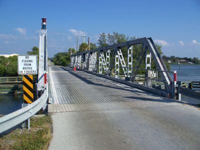
Blackburn Point Bridge, Historic swing road bridge in Osprey, Florida.

Blackburn Point Bridge is a road bridge in Osprey that crosses the Gulf Intracoastal Waterway using a metal Warren pony truss design. The structure features a center bearing pivot system that allows boats to pass underneath when the span rotates.

The bridge was built in 1926 by the Champion Bridge Company of Wilmington, Ohio, linking mainland Florida to Casey Key. This construction supported regional transportation growth during the early 20th century expansion of the area.

The bridge serves local traffic crossing between the mainland and Casey Key, supporting the everyday movement of residents and visitors through this coastal area. Its swing mechanism remains an active part of how people navigate the waterway.

The bridge accommodates two-way traffic with signals coordinating between vehicles and passing boats. Visitors should expect brief waits when the span opens for waterway traffic.

The bridge features uncommon cone-shaped rivet heads visible in its metal truss structure, which was unusual for pony truss designs of that period. This construction detail reflects the quality standards of the Champion Bridge Company.

The community of curious travelers

AroundUs brings together thousands of curated places, local tips, and hidden gems, enriched daily by 60,000 contributors worldwide.

Start exploring
Location
GPS coordinates
27.17944,-82.49472
Latest update
December 12, 2025 09:08
Around this place
Siesta Beach
United States of America

Siesta Beach

11 km
Oscar Scherer State Park
United States of America

Oscar Scherer State Park

2.9 km
Healy Guest House
United States of America

Healy Guest House

15 km
Epiphany Cathedral
United States of America

Epiphany Cathedral

9.8 km
Revere Quality Institute House
United States of America

Revere Quality Institute House

14.9 km
Venetian Waterway Park
United States of America

Venetian Waterway Park

9.9 km
Field Estate
United States of America

Field Estate

12.7 km
Sanderling Beach Club
United States of America

Sanderling Beach Club

7.7 km
Blalock House
United States of America

Blalock House

10.2 km
Edson Keith Estate
United States of America

Edson Keith Estate

10.8 km
Venezia Park Historic District
United States of America

Venezia Park Historic District

10.8 km
Armada Road Multi-Family District
United States of America

Armada Road Multi-Family District

10.2 km
John Nolen Plan of Venice Historic District
United States of America

John Nolen Plan of Venice Historic District

10.6 km
Dr. C. B. Wilson House
United States of America

Dr. C. B. Wilson House

12 km
Eagle Point Historic District
United States of America

Eagle Point Historic District

9.2 km
Edgewood Historic District
United States of America

Edgewood Historic District

11.2 km
Osprey Archeological and Historic Site
United States of America

Osprey Archeological and Historic Site

2.7 km
House at 710 Armada Road South
United States of America

House at 710 Armada Road South

10.2 km
Osprey School
United States of America

Osprey School

2.5 km
Johnson Chapel Missionary Baptist Church
United States of America

Johnson Chapel Missionary Baptist Church

7.1 km
Nokomis Beach Pavilion
United States of America

Nokomis Beach Pavilion

6.6 km
Maine Colony Historic District
United States of America

Maine Colony Historic District

11.4 km
Levillain-Letton House
United States of America

Levillain-Letton House

10.2 km
Bee Ridge Woman's Club
United States of America

Bee Ridge Woman's Club

11.4 km
Lucienne Nielsen House
United States of America

Lucienne Nielsen House

590 m
Bispham-Wilson Historic District
United States of America

Bispham-Wilson Historic District

12.4 km
Waters and Elsa Burrows Historic District
United States of America

Waters and Elsa Burrows Historic District

2.6 km
Johnson Schoolcraft Building
United States of America

Johnson Schoolcraft Building

9.4 km
Show the full map
« Blackburn Point Bridge - Historic swing road bridge in Osprey, Florida » is provided by Around Us (aroundus.com). Images and texts are derived from Wikimedia project under a Creative Commons license. You are allowed to copy, distribute, and modify copies of this page, under the conditions set by the license, as long as this note is clearly visible.

Discover hidden gems everywhere you go!

From secret cafés to breathtaking viewpoints, skip the crowded tourist spots and find places that match your style. Our app makes it easy with voice search, smart filtering, route optimization, and insider tips from travelers worldwide. Download now for the complete mobile experience.

Around Us App Screenshot

A unique approach to discovering new places

Le Figaro

All the places worth exploring

France Info

A tailor-made excursion in just a few clicks

20 Minutes

Around Us
Travel Guide & Maps
Download

Send to your phone

QR Code
1

Open the camera app on your mobile.

2

Point at the QR code with your camera. A notification will appear.

3

Tap the notification to open the link.