Chest opened
+${chestReward.xp} XP
Explorer
NOUVEAU ×${chestReward.collectible.quantity}
tapez pour fermer
Chest locked

Open chests in the app

Around Us is built for your phone — chests unlock when you walk, explore and capture nearby places.

Enable Location

We need your location to show you interesting places around you

Discover nearby places

Find interesting locations and hidden gems around you

Precise directions

Get accurate directions and distances to places

Your location is never shared with other users. It's only used when you tap the location button.

Florida's Turnpike

Log in to your account

Start exploring — it's free

Trusted by 72,986 travelers worldwide

Continue with Google
Continue with Apple
or

We will send you a code to connect

By continuing, you accept our Terms and Conditions and our Privacy Policy

Check your inbox

We've sent a pincode in your inbox. Please enter the code below.

Florida's Turnpike
Discussion Reviews 1 Photos
109k Popularity

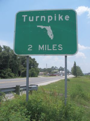
Florida's Turnpike, State toll road system in Florida, US

Florida's Turnpike is a toll road system running from Miami Gardens in the south to Wildwood in the central part of the state, linking several metropolitan areas. The route passes through different landscapes, from urban zones with heavy traffic to more rural stretches.

Construction began in the 1950s as a response to growing population and rising traffic needs following World War II. Over the decades, the route was expanded several times to connect new regions and improve traffic flow.

Floridians commonly refer to the route simply as

Several service plazas along the route offer fuel stations, restaurants, and restrooms, making longer drives more comfortable. Electronic toll systems work with transponders or license plate recognition, so travelers should check payment options before driving.

Since late 2021, the entire route operates without traditional toll booths, relying exclusively on electronic collection. Vehicles pass toll points without stopping, while cameras and sensors automatically record charges.

The community of curious travelers

AroundUs brings together thousands of curated places, local tips, and hidden gems, enriched daily by 60,000 contributors worldwide.

Start exploring
Inception
January 25, 1957
GPS coordinates
27.96530,-81.08460
Latest update
December 12, 2025 22:53
Around this place
Deseret Ranches
United States of America

Deseret Ranches

31.3 km
Brevard Zoo
United States of America

Brevard Zoo

46.5 km
Desert Inn and Restaurant
United States of America

Desert Inn and Restaurant

34.4 km
Kissimmee Prairie Preserve State Park
United States of America

Kissimmee Prairie Preserve State Park

38.8 km
Reptile World Serpentarium
United States of America

Reptile World Serpentarium

33.3 km
Maxwell C. King Center for the Performing Arts
United States of America

Maxwell C. King Center for the Performing Arts

46.7 km
American Muscle Car Museum
United States of America

American Muscle Car Museum

43.4 km
Allen David Broussard Catfish Creek
United States of America

Allen David Broussard Catfish Creek

35.4 km
Monument of States
United States of America

Monument of States

48 km
Henegar Center
United States of America

Henegar Center

48.3 km
Andretti Thrill Park
United States of America

Andretti Thrill Park

46.4 km
Lake Wales Ridge State Forest
United States of America

Lake Wales Ridge State Forest

45.9 km
Liberty Bell Memorial Museum
United States of America

Liberty Bell Memorial Museum

48 km
Osceola County Courthouse
United States of America

Osceola County Courthouse

48.4 km
Old Holy Redeemer Catholic Church
United States of America

Old Holy Redeemer Catholic Church

48.5 km
Airport Museum
United States of America

Airport Museum

47.1 km
Kissimmee Historic District
United States of America

Kissimmee Historic District

48.5 km
First United Methodist Church
United States of America

First United Methodist Church

48 km
Eau Gallie Historic District
United States of America

Eau Gallie Historic District

48.3 km
Church of the Holy Spirit
United States of America

Church of the Holy Spirit

47.9 km
Holy Trinity Episcopal Church
United States of America

Holy Trinity Episcopal Church

47.1 km
The Ice Factory of Central Florida
United States of America

The Ice Factory of Central Florida

43.9 km
Original Melbourne Village Hall
United States of America

Original Melbourne Village Hall

43.4 km
Holy Trinity Episcopal Church Parish
United States of America

Holy Trinity Episcopal Church Parish

47.1 km
Grand Army of the Republic Memorial Hall
United States of America

Grand Army of the Republic Memorial Hall

37.1 km
Persimmon Mound
United States of America

Persimmon Mound

42.3 km
St. Cloud Heritage Museum
United States of America

St. Cloud Heritage Museum

37.2 km
Kissimmee Lighthouse
United States of America

Kissimmee Lighthouse

47.8 km
Show the full map
Reviews
Share your experience

No review yet

Discussions
Start a discussion...

No discussion yet

« Florida's Turnpike - State toll road system in Florida, US » is provided by Around Us (aroundus.com). Images and texts are derived from Wikimedia project under a Creative Commons license. You are allowed to copy, distribute, and modify copies of this page, under the conditions set by the license, as long as this note is clearly visible.

Discover hidden gems everywhere you go!

From secret cafés to breathtaking viewpoints, skip the crowded tourist spots and find places that match your style. Our app makes it easy with voice search, smart filtering, route optimization, and insider tips from travelers worldwide. Download now for the complete mobile experience.

Around Us App Screenshot

A unique approach to discovering new places

Le Figaro

All the places worth exploring

France Info

A tailor-made excursion in just a few clicks

20 Minutes

Around Us
Travel Guide & Maps
Download

Send to your phone

QR Code
1

Open the camera app on your mobile.

2

Point at the QR code with your camera. A notification will appear.

3

Tap the notification to open the link.