Enable Location

We need your location to show you interesting places around you

Discover nearby places

Find interesting locations and hidden gems around you

Precise directions

Get accurate directions and distances to places

Your location is never shared with other users. It's only used when you tap the location button.

Port Orange Causeway

Log in to your account

Start exploring — it's free

Trusted by 63,458 travelers worldwide

Continue with Google
Continue with Apple
or

We will send you a code to connect

By continuing, you accept our Terms and Conditions and our Privacy Policy

Check your inbox

We've sent a pincode in your inbox. Please enter the code below.

Port Orange Causeway
Discussion Reviews 1 Photos
2.8k Popularity

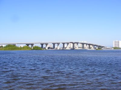
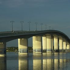
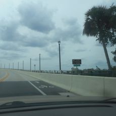
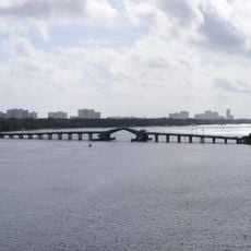
Port Orange Causeway, Road bridge in Port Orange, Florida.

Port Orange Causeway is a road bridge spanning the Halifax River and Intracoastal Waterway with four lanes for vehicle traffic. An adjacent park provides boat launch areas, fishing piers, and picnic facilities for those wanting to stop and spend time outdoors.

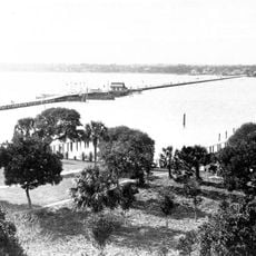
A wooden crossing built in 1906 was destroyed by a hurricane in 1932, leaving the community without a bridge for nearly two decades. A replacement with drawbridge capability opened in 1951 to restore the vital connection.

The causeway serves as a gathering point where locals cross between mainland and coastal areas, connecting their daily routines and recreational interests. Fishing spots and picnic grounds along its edges are places where community members spend time together outdoors.

The bridge offers a straightforward crossing with clear lane markings for safe driving over water. The waterside park facilities are easy to access and provide ample parking and space for recreational activities.

The current structure maintains sufficient clearance above water to allow larger boats to pass underneath without interruption. This contrasts with its predecessor, which required drawbridge operations that stopped vehicle traffic regularly.

The community of curious travelers

AroundUs brings together thousands of curated places, local tips, and hidden gems, enriched daily by 60,000 contributors worldwide.

Start exploring
Location
Inception
1990
GPS coordinates
29.14810,-80.97560
Latest update
December 12, 2025 14:40
Around this place
Ponce de Leon Inlet Light
United States of America

Ponce de Leon Inlet Light

8.8 km
Mary McLeod Bethune Home
United States of America

Mary McLeod Bethune Home

9 km
Dunlawton Plantation and Sugar Mill
United States of America

Dunlawton Plantation and Sugar Mill

3.1 km
Museum of Arts and Sciences
United States of America

Museum of Arts and Sciences

7.7 km
Broadway Bridge
United States of America

Broadway Bridge

8.5 km
Tarragona Tower
United States of America

Tarragona Tower

9 km
Marine Science Center
United States of America

Marine Science Center

8.9 km
The Abbey
United States of America

The Abbey

7.5 km
White Hall
United States of America

White Hall

9 km
Embry-Riddle Observatory
United States of America

Embry-Riddle Observatory

8.4 km
South Beach Street Historic District
United States of America

South Beach Street Historic District

7.5 km
Veterans Memorial Bridge
United States of America

Veterans Memorial Bridge

7.8 km
Halifax Historical Museum
United States of America

Halifax Historical Museum

7.9 km
S. H. Kress and Co. Building
United States of America

S. H. Kress and Co. Building

8.2 km
Spruce Creek Mound Complex
United States of America

Spruce Creek Mound Complex

8.6 km
Delos A. Blodgett House
United States of America

Delos A. Blodgett House

7.6 km
Rogers House
United States of America

Rogers House

8.7 km
South Ridgewood Elementary School
United States of America

South Ridgewood Elementary School

6.8 km
Amos Kling House
United States of America

Amos Kling House

8.2 km
S. Cornelia Young Memorial Library
United States of America

S. Cornelia Young Memorial Library

8.6 km
Gamble Place Historic District
United States of America

Gamble Place Historic District

9.4 km
Grace Episcopal Church and Guild Hall
United States of America

Grace Episcopal Church and Guild Hall

1.3 km
The Art League of Daytona Beach
United States of America

The Art League of Daytona Beach

7.5 km
Dunlawton Avenue Historic District
United States of America

Dunlawton Avenue Historic District

1.7 km
Halifax Drive Historic District
United States of America

Halifax Drive Historic District

1.2 km
Cici and Hyatt Brown Museum of Art
United States of America

Cici and Hyatt Brown Museum of Art

8 km
Veterans Memorial Bridge
United States of America

Veterans Memorial Bridge

7.8 km
Veterans Memorial Bridge
United States of America

Veterans Memorial Bridge

7.8 km
Show the full map
Reviews
Share your experience

No review yet

Discussions
Start a discussion...

No discussion yet

« Port Orange Causeway - Road bridge in Port Orange, Florida » is provided by Around Us (aroundus.com). Images and texts are derived from Wikimedia project under a Creative Commons license. You are allowed to copy, distribute, and modify copies of this page, under the conditions set by the license, as long as this note is clearly visible.

Discover hidden gems everywhere you go!

From secret cafés to breathtaking viewpoints, skip the crowded tourist spots and find places that match your style. Our app makes it easy with voice search, smart filtering, route optimization, and insider tips from travelers worldwide. Download now for the complete mobile experience.

Around Us App Screenshot

A unique approach to discovering new places

Le Figaro

All the places worth exploring

France Info

A tailor-made excursion in just a few clicks

20 Minutes

Around Us
Travel Guide & Maps
Download

Send to your phone

QR Code
1

Open the camera app on your mobile.

2

Point at the QR code with your camera. A notification will appear.

3

Tap the notification to open the link.