Enable Location

We need your location to show you interesting places around you

Discover nearby places

Find interesting locations and hidden gems around you

Precise directions

Get accurate directions and distances to places

Your location is never shared with other users. It's only used when you tap the location button.

Log in to your account

Start exploring — it's free

Trusted by 65,606 travelers worldwide

Continue with Google
Continue with Apple
or

We will send you a code to connect

By continuing, you accept our Terms and Conditions and our Privacy Policy

Check your inbox

We've sent a pincode in your inbox. Please enter the code below.

Dead Lakes State Recreation Area
Discussion Reviews Photo
4.6k Popularity

Dead Lakes State Recreation Area, Recreation area in Gulf County, Florida.

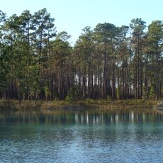
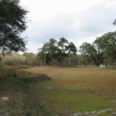
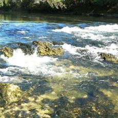
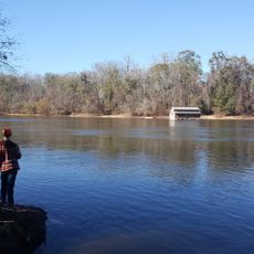
Dead Lakes State Recreation Area is a recreation area in Gulf County, in the Florida Panhandle, bordered by longleaf pines, magnolia trees, and bald cypress standing partly in water. The site offers access to a large body of dark, tannin-stained water and has on-site facilities including a boat ramp, bathrooms, showers, and a fish cleaning station.

The land was used as a fish hatchery from 1936 to 1951, managed by the Florida Fish and Wildlife Conservation Commission. After that, it was opened to the public as a recreation area.

The area sits close to Wewahitchka, a town known for its tupelo honey. The tupelo trees grow right in the flooded zones nearby, and local beekeepers still harvest honey from them in the same way people have done for generations.

The area works best for visitors who bring a boat, since the main access to the water is through the on-site boat ramp. Water levels can vary noticeably depending on the season, so it is worth checking conditions before heading out on the water.

The lakes were formed when sandbars from the Apalachicola River blocked the Chipola River, trapping water over a large area and submerging stands of cypress trees. The trunks and stumps of those trees are still visible today, rising out of the dark water across the lake.

The community of curious travelers

AroundUs brings together thousands of curated places, local tips, and hidden gems, enriched daily by 60,000 contributors worldwide.

Start exploring
Location
GPS coordinates
30.13944,-85.20056
Latest update
March 3, 2026 10:05
Around this place
Apalachicola National Forest
United States of America

Apalachicola National Forest

38.1 km
Fort Gadsden
United States of America

Fort Gadsden

29 km
Orman House
United States of America

Orman House

50 km
Constitution Convention Museum State Park
United States of America

Constitution Convention Museum State Park

39.7 km
Trammell Bridge
United States of America

Trammell Bridge

38.3 km
Bay County Courthouse
United States of America

Bay County Courthouse

44.1 km
First Baptist Church
United States of America

First Baptist Church

44.4 km
Apalachicola Historic District
United States of America

Apalachicola Historic District

50 km
Look and Tremble
United States of America

Look and Tremble

43.1 km
Centennial Building
United States of America

Centennial Building

39.6 km
First Presbyterian Church
United States of America

First Presbyterian Church

45.1 km
Old Gulf County Courthouse
United States of America

Old Gulf County Courthouse

2.7 km
Old Calhoun County Courthouse
United States of America

Old Calhoun County Courthouse

37 km
Robert L. McKenzie House
United States of America

Robert L. McKenzie House

44.3 km
St. Joseph Catholic Mission Church
United States of America

St. Joseph Catholic Mission Church

38.1 km
Sapp House
United States of America

Sapp House

44.1 km
David G. Raney House
United States of America

David G. Raney House

50.2 km
A. A. Payne-John Christo, Sr., House
United States of America

A. A. Payne-John Christo, Sr., House

45.6 km
St. Andrew School
United States of America

St. Andrew School

48.5 km
Sherman Arcade
United States of America

Sherman Arcade

44.3 km
Panama City Center for the Arts
United States of America

Panama City Center for the Arts

44.2 km
Science and Discovery Center of Northwest Florida
United States of America

Science and Discovery Center of Northwest Florida

44.8 km
Torreya State Park
United States of America

Torreya State Park

50.2 km
Schmidt-Godert Farm
United States of America

Schmidt-Godert Farm

28.9 km
Port Theatre
United States of America

Port Theatre

37.6 km
Panhandle Pioneer Settlement
United States of America

Panhandle Pioneer Settlement

37.3 km
Bowlarama Lanes
United States of America

Bowlarama Lanes

47.7 km
Science & Discovery Center of Northwest Florida
United States of America

Science & Discovery Center of Northwest Florida

44.8 km
Show the full map
Reviews
Share your experience

No review yet

Discussions
Start a discussion...

No discussion yet

« Dead Lakes State Recreation Area - Recreation area in Gulf County, Florida » is provided by Around Us (aroundus.com). Images and texts are derived from Wikimedia project under a Creative Commons license. You are allowed to copy, distribute, and modify copies of this page, under the conditions set by the license, as long as this note is clearly visible.

Discover hidden gems everywhere you go!

From secret cafés to breathtaking viewpoints, skip the crowded tourist spots and find places that match your style. Our app makes it easy with voice search, smart filtering, route optimization, and insider tips from travelers worldwide. Download now for the complete mobile experience.

Around Us App Screenshot

A unique approach to discovering new places

Le Figaro

All the places worth exploring

France Info

A tailor-made excursion in just a few clicks

20 Minutes

Around Us
Travel Guide & Maps
Download

Send to your phone

QR Code
1

Open the camera app on your mobile.

2

Point at the QR code with your camera. A notification will appear.

3

Tap the notification to open the link.