Enable Location

We need your location to show you interesting places around you

Discover nearby places

Find interesting locations and hidden gems around you

Precise directions

Get accurate directions and distances to places

Your location is never shared with other users. It's only used when you tap the location button.

Fort Barrington

Log in to your account

Start exploring — it's free

Trusted by 63,637 travelers worldwide

Continue with Google
Continue with Apple
or

We will send you a code to connect

By continuing, you accept our Terms and Conditions and our Privacy Policy

Check your inbox

We've sent a pincode in your inbox. Please enter the code below.

Discussion Reviews 1 Photos
3.1k Popularity

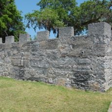
Fort Barrington, Colonial fort in McIntosh County, United States.

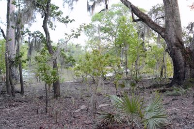
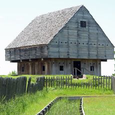
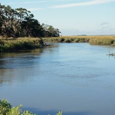
Fort Barrington is a wooden colonial structure located along the Altamaha River, built with earthwork defenses and positioned to control river traffic. The site features military structures designed to monitor the surrounding territories from its strategic location.

The fort was established in 1751 under Lieutenant Robert Baillie's command as a critical defense point against Spanish forces from Florida. It played a key role in the region's early colonial conflicts.

The fort shows how early settlers and military forces shared the landscape and shaped local communities. The remains reveal what daily life was like at the boundary between colonial powers and indigenous peoples.

The site sits on private hunting club property and requires advance permission from landowners before visiting. Contact local historical societies or the county to ask about access conditions and the best time to visit.

Archaeological digs have uncovered military artifacts and structural remains that show how colonial defense systems evolved in the American Southeast. These findings help researchers understand how early forts were actually built and used.

The community of curious travelers

AroundUs brings together thousands of curated places, local tips, and hidden gems, enriched daily by 60,000 contributors worldwide.

Start exploring
Location
GPS coordinates
31.48028,-81.61667
Latest update
December 12, 2025 09:08
Around this place
Fort Frederica National Monument
United States of America

Fort Frederica National Monument

35.9 km
Fort King George
United States of America

Fort King George

23 km
Butler Island Plantation
United States of America

Butler Island Plantation

21.4 km
Hofwyl-Broadfield Plantation
United States of America

Hofwyl-Broadfield Plantation

24.5 km
Harris Neck National Wildlife Refuge
United States of America

Harris Neck National Wildlife Refuge

37.3 km
Wolf Island National Wildlife Refuge
United States of America

Wolf Island National Wildlife Refuge

35 km
Sapelo Island Light
United States of America

Sapelo Island Light

33 km
Christ Church
United States of America

Christ Church

36.2 km
Ashantilly
United States of America

Ashantilly

22.3 km
Sapelo Island Range Front Light
United States of America

Sapelo Island Range Front Light

33.1 km
Duplin River
United States of America

Duplin River

30.9 km
St. Cyprian's Episcopal Church
United States of America

St. Cyprian's Episcopal Church

21.5 km
Ballard School
United States of America

Ballard School

32.4 km
Ludowici Well Pavilion
United States of America

Ludowici Well Pavilion

28.3 km
St. Andrew's Episcopal Church
United States of America

St. Andrew's Episcopal Church

21.5 km
West Darien Historic District
United States of America

West Darien Historic District

20.8 km
Long County Courthouse
United States of America

Long County Courthouse

27.9 km
Walthourville Presbyterian Church
United States of America

Walthourville Presbyterian Church

30 km
Sylvester Mumford House
United States of America

Sylvester Mumford House

31.5 km
Needwood Baptist Church and School
United States of America

Needwood Baptist Church and School

27.7 km
Woodmanston Site
United States of America

Woodmanston Site

27.8 km
Vernon Square-Columbus Square Historic District
United States of America

Vernon Square-Columbus Square Historic District

21.5 km
Wayne County Courthouse
United States of America

Wayne County Courthouse

28.5 km
John W. C. Trowell House
United States of America

John W. C. Trowell House

28.6 km
Leonard Carter House
United States of America

Leonard Carter House

28.5 km
Jesup Drive-In
United States of America

Jesup Drive-In

29.4 km
Historic Strand Dinner Theatre
United States of America

Historic Strand Dinner Theatre

28.9 km
Fort Frederica Visitor Center
United States of America

Fort Frederica Visitor Center

35.8 km
Show the full map
Reviews
Share your experience

No review yet

Discussions
Start a discussion...

No discussion yet

« Fort Barrington - Colonial fort in McIntosh County, United States » is provided by Around Us (aroundus.com). Images and texts are derived from Wikimedia project under a Creative Commons license. You are allowed to copy, distribute, and modify copies of this page, under the conditions set by the license, as long as this note is clearly visible.

Discover hidden gems everywhere you go!

From secret cafés to breathtaking viewpoints, skip the crowded tourist spots and find places that match your style. Our app makes it easy with voice search, smart filtering, route optimization, and insider tips from travelers worldwide. Download now for the complete mobile experience.

Around Us App Screenshot

A unique approach to discovering new places

Le Figaro

All the places worth exploring

France Info

A tailor-made excursion in just a few clicks

20 Minutes

Around Us
Travel Guide & Maps
Download

Send to your phone

QR Code
1

Open the camera app on your mobile.

2

Point at the QR code with your camera. A notification will appear.

3

Tap the notification to open the link.