Chest opened
+${chestReward.xp} XP
Explorer
NOUVEAU ×${chestReward.collectible.quantity}
tapez pour fermer
Chest locked

Open chests in the app

Around Us is built for your phone — chests unlock when you walk, explore and capture nearby places.

Enable Location

We need your location to show you interesting places around you

Discover nearby places

Find interesting locations and hidden gems around you

Precise directions

Get accurate directions and distances to places

Your location is never shared with other users. It's only used when you tap the location button.

Etowah River

Log in to your account

Start exploring — it's free

Trusted by 72,880 travelers worldwide

Continue with Google
Continue with Apple
or

We will send you a code to connect

By continuing, you accept our Terms and Conditions and our Privacy Policy

Check your inbox

We've sent a pincode in your inbox. Please enter the code below.

Etowah River
Discussion Reviews 1 Photos
14.7k Popularity

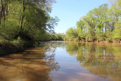
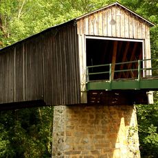
Etowah River, River system in northern Georgia, United States.

The Etowah River is a river system in northern Georgia that flows from Dahlonega through Canton and collects water into Lake Allatoona. It continues its course until it meets the Oostanaula River near Rome.

Early maps by Matthew Carey in 1795 called it the High Town River, while Cherokee records knew it as Hightower River. The name was officially changed to Etowah in 1897.

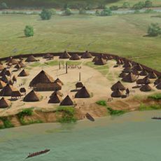
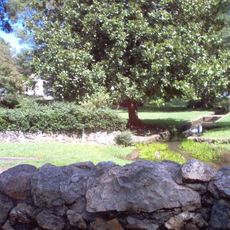
The river runs near the Etowah Indian Mounds in Cartersville, a place where an ancient Mississippian society once lived and left visible traces. Visitors can see these earthen mounds and feel how connected the waterway is to the area's earlier inhabitants.

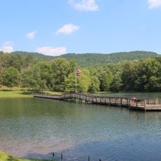
Lake Allatoona, formed by this river, has multiple places where you can access the water for fishing and boating. Plan your visit based on the activities you want to do, as water conditions change with the seasons.

Two endangered fish species, the Cherokee darter and Etowah darter, live only in this water system and nowhere else. Spotting these rare fish reveals why the river is so important for wildlife.

The community of curious travelers

AroundUs brings together thousands of curated places, local tips, and hidden gems, enriched daily by 60,000 contributors worldwide.

Start exploring
Location
GPS coordinates
34.25389,-85.17667
Latest update
December 7, 2025 20:20
Around this place
Berry College
United States of America

Berry College

6.9 km
James H. Floyd State Park
United States of America

James H. Floyd State Park

25.4 km
Oak Hill & The Martha Berry Museum
United States of America

Oak Hill & The Martha Berry Museum

2.6 km
King Archaeological Site
United States of America

King Archaeological Site

21.5 km
Chieftains Museum
United States of America

Chieftains Museum

2.7 km
Marshall Forest
United States of America

Marshall Forest

1.8 km
Clock Tower
United States of America

Clock Tower

691 m
Euharlee Covered Bridge
United States of America

Euharlee Covered Bridge

25.8 km
Forum Civic Center
United States of America

Forum Civic Center

403 m
United States of America

Jackson Hill

1.9 km
Lumpkin Hill
United States of America

Lumpkin Hill

1.1 km
DeSoto Theatre
United States of America

DeSoto Theatre

718 m
United States Post Office and Courthouse
United States of America

United States Post Office and Courthouse

537 m
Old Shorter Hill
United States of America

Old Shorter Hill

721 m
Blossom Hill
United States of America

Blossom Hill

2.3 km
Sardis Presbyterian Church and Cemetery
United States of America

Sardis Presbyterian Church and Cemetery

18.6 km
Hawkes Children's Library
United States of America

Hawkes Children's Library

27.8 km
Between the Rivers Historic District
United States of America

Between the Rivers Historic District

604 m
Cedartown Commercial Historic District
United States of America

Cedartown Commercial Historic District

28 km
Wesley O. Conner House
United States of America

Wesley O. Conner House

22.3 km
Cedartown Waterworks-Woman's Building-Big Spring Park Historic District
United States of America

Cedartown Waterworks-Woman's Building-Big Spring Park Historic District

27.7 km
Summerville Commercial Historic District
United States of America

Summerville Commercial Historic District

29.7 km
John M. Carroll House
United States of America

John M. Carroll House

22.6 km
Cave Spring Commercial Historic District
United States of America

Cave Spring Commercial Historic District

22 km
William D. Cowdry Plantation
United States of America

William D. Cowdry Plantation

21.2 km
Movies at Mount Berry Square
United States of America

Movies at Mount Berry Square

5.5 km
Adairsville Historic District
United States of America

Adairsville Historic District

25.6 km
Emmie Nelson Public Library
United States of America

Emmie Nelson Public Library

25.6 km
Show the full map
Reviews
Share your experience

No review yet

Discussions
Start a discussion...

No discussion yet

« Etowah River - River system in northern Georgia, United States » is provided by Around Us (aroundus.com). Images and texts are derived from Wikimedia project under a Creative Commons license. You are allowed to copy, distribute, and modify copies of this page, under the conditions set by the license, as long as this note is clearly visible.

Discover hidden gems everywhere you go!

From secret cafés to breathtaking viewpoints, skip the crowded tourist spots and find places that match your style. Our app makes it easy with voice search, smart filtering, route optimization, and insider tips from travelers worldwide. Download now for the complete mobile experience.

Around Us App Screenshot

A unique approach to discovering new places

Le Figaro

All the places worth exploring

France Info

A tailor-made excursion in just a few clicks

20 Minutes

Around Us
Travel Guide & Maps
Download

Send to your phone

QR Code
1

Open the camera app on your mobile.

2

Point at the QR code with your camera. A notification will appear.

3

Tap the notification to open the link.