Enable Location

We need your location to show you interesting places around you

Discover nearby places

Find interesting locations and hidden gems around you

Precise directions

Get accurate directions and distances to places

Your location is never shared with other users. It's only used when you tap the location button.

Spalding Drive

Log in to your account

Start exploring — it's free

Trusted by 63,119 travelers worldwide

Continue with Google
Continue with Apple
or

We will send you a code to connect

By continuing, you accept our Terms and Conditions and our Privacy Policy

Check your inbox

We've sent a pincode in your inbox. Please enter the code below.

Spalding Drive
Discussion Reviews 1 Photos
1.3k Popularity

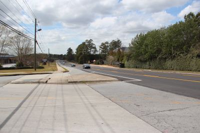
Spalding Drive, Residential road in Sandy Springs, Georgia, United States.

Spalding Drive is a residential road running through northern Atlanta neighborhoods, linking several communities together. It passes schools, post offices, and business parks while traversing hilly terrain with multiple curves.

The route originally followed a Native American trail before becoming a getaway path for Atlanta residents seeking summer homes in northern areas. Over time, different road sections merged into a single unified route.

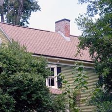
The road carries the name of a pioneering family whose property holdings shaped how the area developed and grew. Their land ownership influenced where neighborhoods formed and how the region expanded northward.

Expect changing road conditions and elevation changes that require careful driving attention. The route has several access points to public facilities and business areas that get busy during peak hours.

Different sections of the road came together from separate earlier routes that had different names. This consolidation created one continuous corridor that developed through stages over time.

The community of curious travelers

AroundUs brings together thousands of curated places, local tips, and hidden gems, enriched daily by 60,000 contributors worldwide.

Start exploring
GPS coordinates
33.96810,-84.25820
Latest update
December 14, 2025 18:12
Around this place
Concourse at Landmark Center
United States of America

Concourse at Landmark Center

11.2 km
Atlanta Athletic Club
United States of America

Atlanta Athletic Club

7.2 km
Victory World Church
United States of America

Victory World Church

7.4 km
Bulloch Hall
United States of America

Bulloch Hall

11.4 km
Chattahoochee River National Recreation Area
United States of America

Chattahoochee River National Recreation Area

6.5 km
Barrington Hall
United States of America

Barrington Hall

11 km
Atlanta Silverbacks Park
United States of America

Atlanta Silverbacks Park

9.3 km
Southeastern Railway Museum
United States of America

Southeastern Railway Museum

9.9 km
Morgan Falls Dam
United States of America

Morgan Falls Dam

11.6 km
Murphey Candler Park
United States of America

Murphey Candler Park

8.8 km
Three Ravinia Drive
United States of America

Three Ravinia Drive

8.8 km
Archibald Smith Plantation Home
United States of America

Archibald Smith Plantation Home

11.2 km
Chattahoochee Nature Center
United States of America

Chattahoochee Nature Center

12.2 km
Autrey Mill Nature Preserve & Heritage Center
United States of America

Autrey Mill Nature Preserve & Heritage Center

6.3 km
Computer Museum of America
United States of America

Computer Museum of America

10.9 km
Superb
United States of America

Superb

9.7 km
Primrose Cottage
United States of America

Primrose Cottage

11.2 km
Teaching Museum North
United States of America

Teaching Museum North

11.3 km
Roswell Historic District
United States of America

Roswell Historic District

10.9 km
Isaac Roberts House
United States of America

Isaac Roberts House

9.3 km
Roswall
United States of America

Roswall

10.9 km
Newtown Elementary School
United States of America

Newtown Elementary School

5.9 km
Faces of War Memorial
United States of America

Faces of War Memorial

11.3 km
Island Ford Lodge
United States of America

Island Ford Lodge

6.5 km
Donaldson-Bannister House and Cemetery
United States of America

Donaldson-Bannister House and Cemetery

6.7 km
Park Towers I
United States of America

Park Towers I

10.8 km
Computer Museum of America
United States of America

Computer Museum of America

10.9 km
City Green at City Springs

City Green at City Springs

12.3 km
Show the full map
Reviews
Share your experience

No review yet

Discussions
Start a discussion...

No discussion yet

« Spalding Drive - Residential road in Sandy Springs, Georgia, United States » is provided by Around Us (aroundus.com). Images and texts are derived from Wikimedia project under a Creative Commons license. You are allowed to copy, distribute, and modify copies of this page, under the conditions set by the license, as long as this note is clearly visible.

Discover hidden gems everywhere you go!

From secret cafés to breathtaking viewpoints, skip the crowded tourist spots and find places that match your style. Our app makes it easy with voice search, smart filtering, route optimization, and insider tips from travelers worldwide. Download now for the complete mobile experience.

Around Us App Screenshot

A unique approach to discovering new places

Le Figaro

All the places worth exploring

France Info

A tailor-made excursion in just a few clicks

20 Minutes

Around Us
Travel Guide & Maps
Download

Send to your phone

QR Code
1

Open the camera app on your mobile.

2

Point at the QR code with your camera. A notification will appear.

3

Tap the notification to open the link.