Enable Location

We need your location to show you interesting places around you

Discover nearby places

Find interesting locations and hidden gems around you

Precise directions

Get accurate directions and distances to places

Your location is never shared with other users. It's only used when you tap the location button.

Dames Point Bridge

Log in to your account

Start exploring — it's free

Trusted by 63,018 travelers worldwide

Continue with Google
Continue with Apple
or

We will send you a code to connect

By continuing, you accept our Terms and Conditions and our Privacy Policy

Check your inbox

We've sent a pincode in your inbox. Please enter the code below.

Discussion Reviews 1 Photos
22.6k Popularity

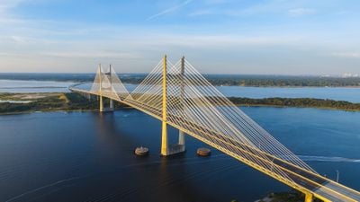
Dames Point Bridge, Cable-stayed bridge in Jacksonville, United States.

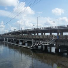
Dames Point Bridge is a cable-stayed crossing over the St. Johns River in Jacksonville, rising on H-shaped concrete towers that stand 144 meters tall and spanning a total of 3218 meters. The roadway carries six lanes of Interstate 295 in a gentle arc across the wide river, forming one of the most prominent crossings in northeast Florida.

Construction started in 1985 and concluded in 1989 to meet growing traffic demands in the greater Jacksonville area. The crossing became one of the first major examples of a prestressed concrete cable-stayed design in the United States.

Local drivers typically refer to it as Dames Point rather than using the official Napoleon Bonaparte Broward designation in everyday conversation. The structure links Arlington to the south with areas north of the river and shapes the city's profile as a landmark visible across the region.

The crossing remains open around the clock and provides a direct route for through traffic on Interstate 295. Weather conditions can be noticeable, especially wind, when driving across the long exposed roadway.

The cable arrangement follows a harp pattern in which the cables run nearly parallel from the tower to the roadway. This design approach remained the only one of its kind across the country until 2003 and requires roughly 34 kilometers of steel wire for the entire suspension system.

The community of curious travelers

AroundUs brings together thousands of curated places, local tips, and hidden gems, enriched daily by 60,000 contributors worldwide.

Start exploring
Location
Inception
1989
Height
144 m
Length
3,218 m
Made from material
prestressed concrete, reinforced concrete, steel
GPS coordinates
30.38580,-81.55830
Latest update
December 20, 2025 15:47
Around this place
Daily's Place
United States of America

Daily's Place

10.4 km
Fort Caroline
United States of America

Fort Caroline

5.5 km
United States of America

Jacksonville Sheriff's Office

11.2 km
Mathews Bridge
United States of America

Mathews Bridge

8.7 km
Hart Bridge
United States of America

Hart Bridge

10.3 km
First Baptist Church of Jacksonville
United States of America

First Baptist Church of Jacksonville

11.3 km
Jacksonville Public Library
United States of America

Jacksonville Public Library

11.4 km
Norman Studios
United States of America

Norman Studios

6.7 km
Metropolitan Park
United States of America

Metropolitan Park

10.7 km
Morocco Temple
United States of America

Morocco Temple

11.3 km
D. B. Milne Field
United States of America

D. B. Milne Field

5.6 km
Bethel Baptist Institutional Church
United States of America

Bethel Baptist Institutional Church

11.1 km
Yellow Bluff Fort Historic State Park
United States of America

Yellow Bluff Fort Historic State Park

1.5 km
Karpeles Manuscript Library Museum, Jacksonville
United States of America

Karpeles Manuscript Library Museum, Jacksonville

10.9 km
Henry John Klutho House
United States of America

Henry John Klutho House

10.3 km
Marabanong
United States of America

Marabanong

9.8 km
Jacksonville Fire Museum
United States of America

Jacksonville Fire Museum

11.2 km
Mount Zion AME Church
United States of America

Mount Zion AME Church

9.6 km
Trout River Bridge
United States of America

Trout River Bridge

10.4 km
United States of America

Old St. Luke's Hospital

10.8 km
John S. Sammis House
United States of America

John S. Sammis House

8.8 km
Merrill House Museum
United States of America

Merrill House Museum

10.5 km
Hands on Childrens Museum
United States of America

Hands on Childrens Museum

11.1 km
South Atlantic Investment Corporation Building
United States of America

South Atlantic Investment Corporation Building

11 km
Tree Hill Nature Center
United States of America

Tree Hill Nature Center

6.3 km
Buckman and Ulmer Building
United States of America

Buckman and Ulmer Building

11.1 km
St. Andrew's Episcopal Church
United States of America

St. Andrew's Episcopal Church

10.6 km
Old Trout River Bridge
United States of America

Old Trout River Bridge

8.6 km
Show the full map
Reviews
Share your experience

No review yet

Discussions
Start a discussion...

No discussion yet

« Dames Point Bridge - Cable-stayed bridge in Jacksonville, United States » is provided by Around Us (aroundus.com). Images and texts are derived from Wikimedia project under a Creative Commons license. You are allowed to copy, distribute, and modify copies of this page, under the conditions set by the license, as long as this note is clearly visible.

Discover hidden gems everywhere you go!

From secret cafés to breathtaking viewpoints, skip the crowded tourist spots and find places that match your style. Our app makes it easy with voice search, smart filtering, route optimization, and insider tips from travelers worldwide. Download now for the complete mobile experience.

Around Us App Screenshot

A unique approach to discovering new places

Le Figaro

All the places worth exploring

France Info

A tailor-made excursion in just a few clicks

20 Minutes

Around Us
Travel Guide & Maps
Download

Send to your phone

QR Code
1

Open the camera app on your mobile.

2

Point at the QR code with your camera. A notification will appear.

3

Tap the notification to open the link.