Enable Location

We need your location to show you interesting places around you

Discover nearby places

Find interesting locations and hidden gems around you

Precise directions

Get accurate directions and distances to places

Your location is never shared with other users. It's only used when you tap the location button.

Log in to your account

Save your favorite places
Create custom travel routes
Rate and review places
Access the full interactive map
Continue with Google
Continue with Apple
Continue with email
By continuing, you accept our Terms and Conditions and our Privacy Policy
Create an account
Add to collection
Map
Suggest a change
Share

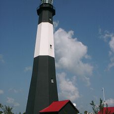
Bloody Point Range Lights, Range lights on Daufuskie Island, South Carolina, US

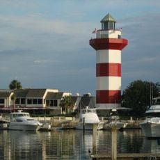
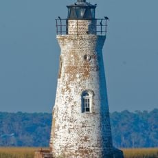
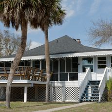
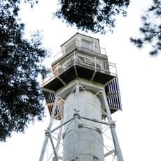
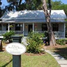
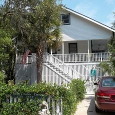
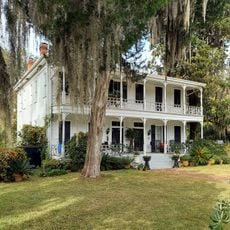
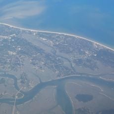
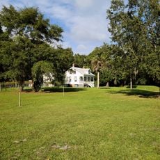
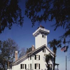
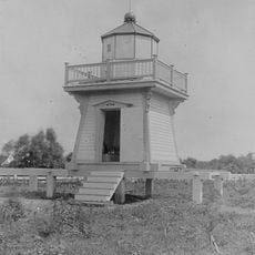
Bloody Point Range Lights is a historic navigation system on Daufuskie Island made up of two separate structures: a front light built within a keeper's house and a rear light housed in a 91-foot iron skeletal tower. The pair worked together as a guidance system to help ships navigate safely through Calibogue Sound.

Congress authorized construction of this navigation system in 1871 to guide ships between Hilton Head Island and Daufuskie Island. Coastal erosion forced the front light to relocate in 1899, after which it took on the role of the rear light at its new location.

The lights served as beacons of the maritime tradition along this coast, guiding countless vessels safely through dangerous waters. They remain symbols of the seafaring heritage that defined life in this region for generations.

The site can be reached by traveling to Daufuskie Island, accessible by ferry or private boat. The rear light now operates as a private navigation aid for the Haig Point Club, so public access may be limited or restricted.

The front light structure had an unusual fate: forced by coastal erosion to change location, it assumed the role of the rear light at its new position. This shift showed how early navigation systems adapted to the changing coastline.

Location: South Carolina

Inception: 1883

GPS coordinates: 32.09710,-80.87320

Latest update: December 14, 2025 14:24

Photos
Around this place
Bonaventure Cemetery
United States of America

Bonaventure Cemetery

17 km
Harbour Town Golf Links
United States of America

Harbour Town Golf Links

7.4 km
Fort James Jackson
United States of America

Fort James Jackson

15.5 km
Coligny Beach Park
United States of America

Coligny Beach Park

12.5 km
Tybee Island Lighthouse and Museum
United States of America

Tybee Island Lighthouse and Museum

8.7 km
Harbour Town Lighthouse
United States of America

Harbour Town Lighthouse

7.3 km
Harbour Town Lighthouse
United States of America

Harbour Town Lighthouse

7.3 km
Cockspur Island Light
United States of America

Cockspur Island Light

8.3 km
United States of America

Stoney-Baynard Plantation

6.6 km
Tybee Island Strand Cottages Historic District
United States of America

Tybee Island Strand Cottages Historic District

11.5 km
Hilton Head Range Rear Light
United States of America

Hilton Head Range Rear Light

14.6 km
Fort Jackson
United States of America

Fort Jackson

15.5 km
Seven Oaks, Bluffton SC
United States of America

Seven Oaks, Bluffton SC

15.1 km
Heyward House and Historical Center
United States of America

Heyward House and Historical Center

15.2 km
Tybee Island Range Front Light
United States of America

Tybee Island Range Front Light

7.8 km
Bluffton Historic District
United States of America

Bluffton Historic District

15.1 km
Eureka Club-Farr's Point
United States of America

Eureka Club-Farr's Point

18.4 km
D. Hasell Heyward House
United States of America

D. Hasell Heyward House

15.4 km
Dutton-Waller Raised Tybee Cottage
United States of America

Dutton-Waller Raised Tybee Cottage

11 km
All Saints Episcopal Church
United States of America

All Saints Episcopal Church

10.7 km
Campbell Chapel African Methodist Episcopal Church
United States of America

Campbell Chapel African Methodist Episcopal Church

15.5 km
Patz Brothers House
United States of America

Patz Brothers House

15.5 km
Hilton Head Island
United States of America

Hilton Head Island

16.7 km
Silver Dew Winery
United States of America

Silver Dew Winery

90 m
Haig Point Range rear light
United States of America

Haig Point Range rear light

6.4 km
Haig Point Range front light
United States of America

Haig Point Range front light

5.4 km
Fort Pulaski National Monument Visitor Center
United States of America

Fort Pulaski National Monument Visitor Center

8 km
Hilton Head Island Beach
United States of America

Hilton Head Island Beach

12.6 km
Show the full map
Reviews

Visited this place? Tap the stars to rate it and share your experience / photos with the community! Try now! You can cancel it anytime.

« Bloody Point Range Lights - Range lights on Daufuskie Island, South Carolina, US » is provided by Around Us (aroundus.com). Images and texts are derived from Wikimedia project under a Creative Commons license. You are allowed to copy, distribute, and modify copies of this page, under the conditions set by the license, as long as this note is clearly visible.

Discover hidden gems everywhere you go!

From secret cafés to breathtaking viewpoints, skip the crowded tourist spots and find places that match your style. Our app makes it easy with voice search, smart filtering, route optimization, and insider tips from travelers worldwide. Download now for the complete mobile experience.

Around Us App Screenshot

A unique approach to discovering new places

Le Figaro

All the places worth exploring

France Info

A tailor-made excursion in just a few clicks

20 Minutes