Enable Location

We need your location to show you interesting places around you

Discover nearby places

Find interesting locations and hidden gems around you

Precise directions

Get accurate directions and distances to places

Your location is never shared with other users. It's only used when you tap the location button.

Santee Indian Mound and Fort Watson

Log in to your account

Start exploring — it's free

Trusted by 61,808 travelers worldwide

Continue with Google
Continue with Apple
or

We will send you a code to connect

By continuing, you accept our Terms and Conditions and our Privacy Policy

Check your inbox

We've sent a pincode in your inbox. Please enter the code below.

Santee Indian Mound and Fort Watson, Archaeological site and historic fort in Clarendon County, United States.

Description

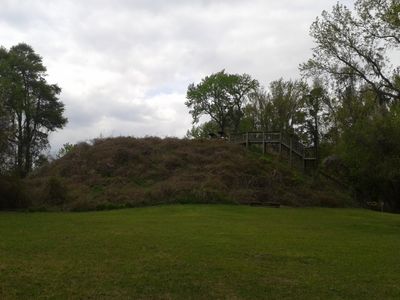
Santee Indian Mound is an earthen rise near Summerton built by Native Americans over several hundred years and later modified by military forces. The structure reaches above the surrounding terrain and shows physical evidence of both ceremonial and defensive uses across different time periods.

History

The mound grew over centuries as an important gathering and ceremonial place for the local population before European settlement arrived. In 1780 British soldiers quickly built defensive structures on top to control the region during the Revolutionary War.

Culture

The mound shows traces of different groups who used this place over long periods. Visitors can observe how people first gathered on the high ground to watch the surrounding lands, then later built military defenses on the same spot.

Practical

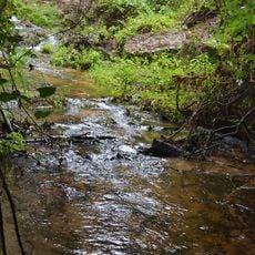
The site sits within a wildlife refuge and is reasonably easy to access. Wear proper footwear since the mound is walkable but the ground can be damp, especially after rain.

Did you know?

British soldiers built defenses on top that seemed difficult to attack, but American troops secretly erected a tall wooden tower overnight that looked down on the fortification. The sudden height advantage forced the British to abandon their position without a major fight.

Location
GPS coordinates
33.53900,-80.43780
Latest update
December 14, 2025 12:24

AroundUs brings together thousands of curated places, local tips, and hidden gems, enriched daily by 60,000 contributors worldwide. Discover all places nearby (Clarendon County).

Around this place
United States of America

Lake Marion

19.3 km
Millford Plantation
United States of America

Millford Plantation

25.1 km
Poinsett State Park
United States of America

Poinsett State Park

31.3 km
Oliver C. Dawson Stadium
United States of America

Oliver C. Dawson Stadium

38 km
Francis Beidler Forest
United States of America

Francis Beidler Forest

34.7 km
Santee National Wildlife Refuge
United States of America

Santee National Wildlife Refuge

10.8 km
Indian Fields Methodist Campground
United States of America

Indian Fields Methodist Campground

36.6 km
Providence Methodist Church
United States of America

Providence Methodist Church

18.7 km
Midway Plantation
United States of America

Midway Plantation

28.2 km
Davis House
United States of America

Davis House

23.4 km
Calhoun County Courthouse
United States of America

Calhoun County Courthouse

34.6 km
Lawson's Pond Plantation
United States of America

Lawson's Pond Plantation

27.4 km
Lowman Hall, South Carolina State College
United States of America

Lowman Hall, South Carolina State College

38.9 km
Ulmer-Summers House
United States of America

Ulmer-Summers House

25.9 km
Oakland Plantation
United States of America

Oakland Plantation

26.8 km
Col. Olin M. Dantzler House
United States of America

Col. Olin M. Dantzler House

34 km
Haigler House
United States of America

Haigler House

22.7 km
Numertia Plantation
United States of America

Numertia Plantation

22.7 km
Hodge Hall
United States of America

Hodge Hall

38.7 km
J. Clinton Brogdon House
United States of America

J. Clinton Brogdon House

34.1 km
Puritan Farm
United States of America

Puritan Farm

37.7 km
Donald Bruce House
United States of America

Donald Bruce House

35.7 km
Col. J.A. Banks House
United States of America

Col. J.A. Banks House

34.4 km
Calhoun County Library
United States of America

Calhoun County Library

34.3 km
Tingley Memorial Hall, Claflin College
United States of America

Tingley Memorial Hall, Claflin College

38.9 km
Manning Library
United States of America

Manning Library

27.6 km
Manning Commercial Historic District
United States of America

Manning Commercial Historic District

27.3 km
Claflin College Historic District
United States of America

Claflin College Historic District

38.9 km
Show the full map
« Santee Indian Mound and Fort Watson - Archaeological site and historic fort in Clarendon County, United States » is provided by Around Us (aroundus.com). Images and texts are derived from Wikimedia project under a Creative Commons license. You are allowed to copy, distribute, and modify copies of this page, under the conditions set by the license, as long as this note is clearly visible.

Discover hidden gems everywhere you go!

From secret cafés to breathtaking viewpoints, skip the crowded tourist spots and find places that match your style. Our app makes it easy with voice search, smart filtering, route optimization, and insider tips from travelers worldwide. Download now for the complete mobile experience.

Around Us App Screenshot

A unique approach to discovering new places

Le Figaro

All the places worth exploring

France Info

A tailor-made excursion in just a few clicks

20 Minutes

Around Us
Travel Guide & Maps
Download

Send to your phone

QR Code
1

Open the camera app on your mobile.

2

Point at the QR code with your camera. A notification will appear.

3

Tap the notification to open the link.