Enable Location

We need your location to show you interesting places around you

Discover nearby places

Find interesting locations and hidden gems around you

Precise directions

Get accurate directions and distances to places

Your location is never shared with other users. It's only used when you tap the location button.

Log in to your account

Start exploring — it's free

Trusted by 63,689 travelers worldwide

Continue with Google
Continue with Apple
or

We will send you a code to connect

By continuing, you accept our Terms and Conditions and our Privacy Policy

Check your inbox

We've sent a pincode in your inbox. Please enter the code below.

Discussion Reviews Photo
2.5k Popularity

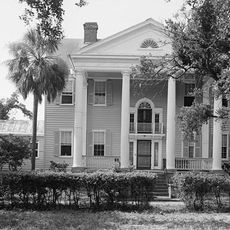
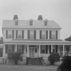
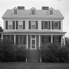
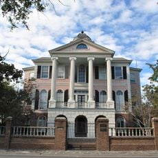
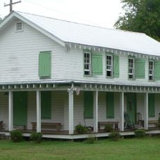
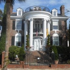
Arnoldus Vander Horst House, 18th-century plantation house in Kiawah Island, US.

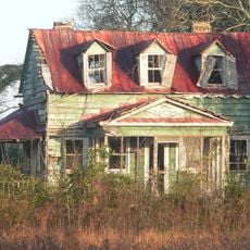
The Arnoldus Vander Horst House is an 18th-century residence with symmetrical windows, detailed woodwork, and a raised foundation typical of plantation homes in South Carolina. The building's form and details reflect the wealth of its original owners.

Built in 1770, the house belonged to Arnoldus Vanderhorst, who later became governor of South Carolina. He played an important role in regional politics during the period after the American Revolution.

The home shows how wealthy plantation owners arranged their living spaces and which rooms mattered most to them in daily life. The interiors reflect the family's lifestyle and remain visible to visitors today.

The house sits on Kiawah Island and is accessible through organized historical tours held during the year. Visitors should check ahead since tours run at specific times.

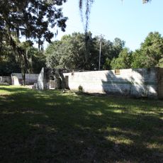
Many original building materials and construction methods from the 18th century remain in the structure, showing how craftspeople worked at that time. These features make it a valuable example of historical craftsmanship.

The community of curious travelers

AroundUs brings together thousands of curated places, local tips, and hidden gems, enriched daily by 60,000 contributors worldwide.

Start exploring
Location
Inception
1770
GPS coordinates
32.61667,-80.07306
Latest update
December 12, 2025 17:40
Around this place
Angel Oak
United States of America

Angel Oak

11.2 km
McLeod Plantation
United States of America

McLeod Plantation

18.8 km
Morris Island Light
United States of America

Morris Island Light

19.8 km
United States of America

Charleston Tea Plantation

10.6 km
Botany Bay Plantation Wildlife Management Area
United States of America

Botany Bay Plantation Wildlife Management Area

16.7 km
Fenwick Hall
United States of America

Fenwick Hall

15.3 km
William Seabrook House
United States of America

William Seabrook House

19.6 km
Hutchinson House
United States of America

Hutchinson House

18 km
Secessionville Historic District
United States of America

Secessionville Historic District

15.7 km
John F. Limehouse Memorial Bridge
United States of America

John F. Limehouse Memorial Bridge

19.1 km
Oak Island
United States of America

Oak Island

16.9 km
Cassina Point
United States of America

Cassina Point

16.9 km
Charleston Tea Garden
United States of America

Charleston Tea Garden

10.5 km
Paul Gelegotis Bridge
United States of America

Paul Gelegotis Bridge

16.3 km
McLeod Plantation Historic Site
United States of America

McLeod Plantation Historic Site

18.7 km
John's Island Presbyterian Church
United States of America

John's Island Presbyterian Church

7.8 km
The Progressive Club
United States of America

The Progressive Club

7.3 km
Wappoo Creek Bridge
United States of America

Wappoo Creek Bridge

19.1 km
Edisto Island Baptist Church
United States of America

Edisto Island Baptist Church

20.4 km
Faber-Ward House
United States of America

Faber-Ward House

21.3 km
Andrew B. Murray Vocational School
United States of America

Andrew B. Murray Vocational School

21.4 km
Stono River Slave Rebellion Site
United States of America

Stono River Slave Rebellion Site

20.2 km
Trinity Episcopal Church
United States of America

Trinity Episcopal Church

20.4 km
Seashore Farmers' Lodge No. 767
United States of America

Seashore Farmers' Lodge No. 767

12.3 km
Tristram Hyde House
United States of America

Tristram Hyde House

21.3 km
Splash Zone
United States of America

Splash Zone

15.4 km
Seabrook Beach
United States of America

Seabrook Beach

9.7 km
Edingsville Beach
United States of America

Edingsville Beach

20.7 km
Show the full map
Reviews
Share your experience

No review yet

Discussions
Start a discussion...

No discussion yet

« Arnoldus Vander Horst House - 18th-century plantation house in Kiawah Island, US » is provided by Around Us (aroundus.com). Images and texts are derived from Wikimedia project under a Creative Commons license. You are allowed to copy, distribute, and modify copies of this page, under the conditions set by the license, as long as this note is clearly visible.

Discover hidden gems everywhere you go!

From secret cafés to breathtaking viewpoints, skip the crowded tourist spots and find places that match your style. Our app makes it easy with voice search, smart filtering, route optimization, and insider tips from travelers worldwide. Download now for the complete mobile experience.

Around Us App Screenshot

A unique approach to discovering new places

Le Figaro

All the places worth exploring

France Info

A tailor-made excursion in just a few clicks

20 Minutes

Around Us
Travel Guide & Maps
Download

Send to your phone

QR Code
1

Open the camera app on your mobile.

2

Point at the QR code with your camera. A notification will appear.

3

Tap the notification to open the link.