Enable Location

We need your location to show you interesting places around you

Discover nearby places

Find interesting locations and hidden gems around you

Precise directions

Get accurate directions and distances to places

Your location is never shared with other users. It's only used when you tap the location button.

John F. Limehouse Memorial Bridge

Log in to your account

Start exploring — it's free

Trusted by 65,866 travelers worldwide

Continue with Google
Continue with Apple
or

We will send you a code to connect

By continuing, you accept our Terms and Conditions and our Privacy Policy

Check your inbox

We've sent a pincode in your inbox. Please enter the code below.

John F. Limehouse Memorial Bridge
Discussion Reviews 1 Photos
3k Popularity

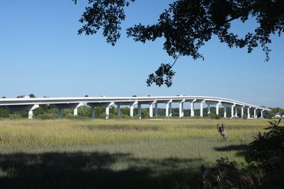
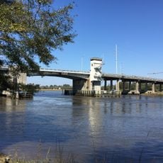
John F. Limehouse Memorial Bridge, Road bridge over Stono River near Charleston, United States.

The John F. Limehouse Memorial Bridge is a road bridge over the Stono River in South Carolina, carrying four lanes of traffic. It has enough clearance underneath to let larger vessels pass without any moving parts in the structure.

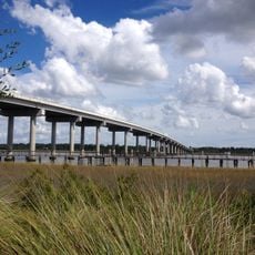
A swing bridge built in 1929 once stood here, forcing vessel traffic to stop and wait each time a boat needed to pass through. It was replaced in 2003 by the current fixed-span bridge, which removed that bottleneck entirely.

The bridge connects Johns Island to the mainland and is part of everyday life for people living on the island, who cross it to reach work, shops, and services. From the road surface, drivers get an open view over the tidal flats and salt marshes typical of the South Carolina coast.

The bridge is part of a main road and can get busy during morning and late afternoon commuting hours. Visiting outside those times makes the crossing more relaxed if you want to take in the views over the water.

When the old swing bridge was torn down, the materials were not thrown away but sunk offshore as part of an artificial reef program run by the South Carolina Department of Natural Resources. Divers and anglers now visit that underwater structure, which has become home to a variety of marine life.

The community of curious travelers

AroundUs brings together thousands of curated places, local tips, and hidden gems, enriched daily by 60,000 contributors worldwide.

Start exploring
Location
Inception
2003
Official opening
2003
GPS coordinates
32.78580,-80.10780
Latest update
March 3, 2026 13:54
Around this place
Magnolia Plantation and Gardens
United States of America

Magnolia Plantation and Gardens

10.3 km
United States of America

Boeing South Carolina

12.6 km
Drayton Hall
United States of America

Drayton Hall

9.9 km
Middleton Place
United States of America

Middleton Place

13.2 km
Charles Towne Landing
United States of America

Charles Towne Landing

11.6 km
Johnson Hagood Stadium
United States of America

Johnson Hagood Stadium

14.2 km
Hampton Park
United States of America

Hampton Park

14.3 km
Magnolia Plantation
United States of America

Magnolia Plantation

10.3 km
Magnolia Gardens
United States of America

Magnolia Gardens

10.1 km
Fenwick Hall
United States of America

Fenwick Hall

7.5 km
William Enston Home
United States of America

William Enston Home

15 km
Ashley River Historic District
United States of America

Ashley River Historic District

14.2 km
General William C. Westmoreland Bridge
United States of America

General William C. Westmoreland Bridge

9.4 km
St. Andrews Episcopal Church
United States of America

St. Andrews Episcopal Church

8 km
West Point Rice Mill
United States of America

West Point Rice Mill

14.7 km
Summerall Chapel
United States of America

Summerall Chapel

14 km
Greek Orthodox Church of the Holy Trinity
United States of America

Greek Orthodox Church of the Holy Trinity

15 km
Paul Gelegotis Bridge
United States of America

Paul Gelegotis Bridge

9.9 km
McLeod Plantation Historic Site
United States of America

McLeod Plantation Historic Site

12.9 km
John's Island Presbyterian Church
United States of America

John's Island Presbyterian Church

11.3 km
Inouye Marksmanship Center
United States of America

Inouye Marksmanship Center

13.5 km
The Progressive Club
United States of America

The Progressive Club

13.6 km
Wappoo Creek Bridge
United States of America

Wappoo Creek Bridge

12.7 km
Jonathan Lucas House
United States of America

Jonathan Lucas House

14.9 km
Stono River Slave Rebellion Site
United States of America

Stono River Slave Rebellion Site

3.5 km
Charles Towne Landing State Historic Site
United States of America

Charles Towne Landing State Historic Site

11.8 km
Regal Charles Towne Square Stadium 18
United States of America

Regal Charles Towne Square Stadium 18

13.6 km
Ashley River Memorial Bridge, Charleston, South Carolina
United States of America

Ashley River Memorial Bridge, Charleston, South Carolina

13.7 km
Show the full map
Reviews
Share your experience

No review yet

Discussions
Start a discussion...

No discussion yet

« John F. Limehouse Memorial Bridge - Road bridge over Stono River near Charleston, United States » is provided by Around Us (aroundus.com). Images and texts are derived from Wikimedia project under a Creative Commons license. You are allowed to copy, distribute, and modify copies of this page, under the conditions set by the license, as long as this note is clearly visible.

Discover hidden gems everywhere you go!

From secret cafés to breathtaking viewpoints, skip the crowded tourist spots and find places that match your style. Our app makes it easy with voice search, smart filtering, route optimization, and insider tips from travelers worldwide. Download now for the complete mobile experience.

Around Us App Screenshot

A unique approach to discovering new places

Le Figaro

All the places worth exploring

France Info

A tailor-made excursion in just a few clicks

20 Minutes

Around Us
Travel Guide & Maps
Download

Send to your phone

QR Code
1

Open the camera app on your mobile.

2

Point at the QR code with your camera. A notification will appear.

3

Tap the notification to open the link.