Chest opened
+${chestReward.xp} XP
Explorer
NOUVEAU ×${chestReward.collectible.quantity}
tapez pour fermer
Chest locked

Open chests in the app

Around Us is built for your phone — chests unlock when you walk, explore and capture nearby places.

Enable Location

We need your location to show you interesting places around you

Discover nearby places

Find interesting locations and hidden gems around you

Precise directions

Get accurate directions and distances to places

Your location is never shared with other users. It's only used when you tap the location button.

Log in to your account

Start exploring — it's free

Trusted by 72,888 travelers worldwide

Continue with Google
Continue with Apple
or

We will send you a code to connect

By continuing, you accept our Terms and Conditions and our Privacy Policy

Check your inbox

We've sent a pincode in your inbox. Please enter the code below.

Casmalia Resources
Discussion Reviews Photo
2k Popularity

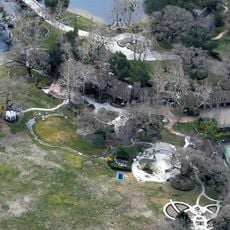
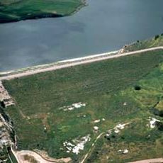
Casmalia Resources, Hazardous waste landfill site near Casmalia, California, United States.

Casmalia Resources is a closed landfill in California that holds thousands of tons of hazardous waste from industrial, oil, and agricultural operations. The site spans several acres of contaminated land with various types of pollutants remaining in the soil and groundwater.

The landfill opened in 1973 and initially accepted waste from oil and agricultural operations before closing in 1985. The site was later added to the national Superfund program as contamination posed significant environmental and health risks.

Local residents organized protests in 1985, blocking the entrance to prevent waste deliveries and expressing concerns about environmental contamination.

The site is not open to visitors as it is a contaminated Superfund location monitored by authorities. Those interested can access information about cleanup progress and environmental assessments through public agency websites.

The site received tens of thousands of gallons of toxic liquid waste daily from Stringfellow Acid Pits, which became one of the nation's first Superfund designations. This connection shows how closely contamination problems were linked across the region.

The community of curious travelers

AroundUs brings together thousands of curated places, local tips, and hidden gems, enriched daily by 60,000 contributors worldwide.

Start exploring
GPS coordinates
34.86287,-120.54408
Latest update
December 14, 2025 09:43
Around this place
Neverland Ranch
United States of America

Neverland Ranch

43.7 km
Guadalupe-Nipomo Dunes
United States of America

Guadalupe-Nipomo Dunes

15.9 km
Pismo State Beach
United States of America

Pismo State Beach

28.7 km
Point Sal State Beach
United States of America

Point Sal State Beach

10.4 km
Guadalupe-Nipomo Dunes National Wildlife Refuge
United States of America

Guadalupe-Nipomo Dunes National Wildlife Refuge

16.9 km
Twitchell Reservoir
United States of America

Twitchell Reservoir

24.4 km
Oceano Dunes
United States of America

Oceano Dunes

28.2 km
Point Arguello Light
United States of America

Point Arguello Light

33.2 km
Islay Hill
United States of America

Islay Hill

43.1 km
Pismo Beach
United States of America

Pismo Beach

29.5 km
La Purisima Mission
United States of America

La Purisima Mission

24.2 km
Dana Adobe
United States of America

Dana Adobe

19.6 km
San Luis Obispo Octagon Barn
United States of America

San Luis Obispo Octagon Barn

43.4 km
Point San Luis Light
United States of America

Point San Luis Light

38.6 km
Vandenberg Space Force Base Space Launch Complex 10
United States of America

Vandenberg Space Force Base Space Launch Complex 10

13.1 km
Los Alamos Ranch House
United States of America

Los Alamos Ranch House

23.7 km
Chapel of San Ramon
United States of America

Chapel of San Ramon

27.7 km
Arroyo Grande IOOF Hall
United States of America

Arroyo Grande IOOF Hall

29 km
John Price House
United States of America

John Price House

32.9 km
Olde Port Beach
United States of America

Olde Port Beach

39.7 km
Fisherman's Beach
United States of America

Fisherman's Beach

39.7 km
Avila Beach Resort Golf Course
United States of America

Avila Beach Resort Golf Course

40.1 km
Pirates Cove
United States of America

Pirates Cove

38.1 km
Point San Luis light
United States of America

Point San Luis light

38.5 km
Espada Bluff
United States of America

Espada Bluff

36.9 km
Minuteman Beach
United States of America

Minuteman Beach

6.2 km
Zaca Creek Bridge No. 1
United States of America

Zaca Creek Bridge No. 1

40.3 km
Zaca Creek Bridge No. 2
United States of America

Zaca Creek Bridge No. 2

40.7 km
Show the full map
Reviews
Share your experience

No review yet

Discussions
Start a discussion...

No discussion yet

« Casmalia Resources - Hazardous waste landfill site near Casmalia, California, United States » is provided by Around Us (aroundus.com). Images and texts are derived from Wikimedia project under a Creative Commons license. You are allowed to copy, distribute, and modify copies of this page, under the conditions set by the license, as long as this note is clearly visible.

Discover hidden gems everywhere you go!

From secret cafés to breathtaking viewpoints, skip the crowded tourist spots and find places that match your style. Our app makes it easy with voice search, smart filtering, route optimization, and insider tips from travelers worldwide. Download now for the complete mobile experience.

Around Us App Screenshot

A unique approach to discovering new places

Le Figaro

All the places worth exploring

France Info

A tailor-made excursion in just a few clicks

20 Minutes

Around Us
Travel Guide & Maps
Download

Send to your phone

QR Code
1

Open the camera app on your mobile.

2

Point at the QR code with your camera. A notification will appear.

3

Tap the notification to open the link.