Enable Location

We need your location to show you interesting places around you

Discover nearby places

Find interesting locations and hidden gems around you

Precise directions

Get accurate directions and distances to places

Your location is never shared with other users. It's only used when you tap the location button.

Point Sal State Beach

Log in to your account

Start exploring — it's free

Trusted by 61,367 travelers worldwide

Continue with Google
Continue with Apple
or

We will send you a code to connect

By continuing, you accept our Terms and Conditions and our Privacy Policy

Check your inbox

We've sent a pincode in your inbox. Please enter the code below.

Point Sal State Beach

Point Sal State Beach, State beach on California's Pacific coast, United States.

Description

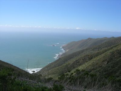
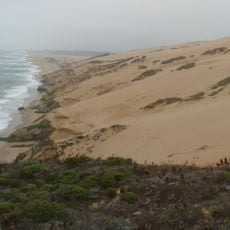
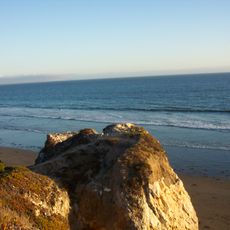
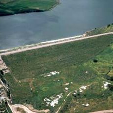
Point Sal State Beach is a 32-acre coastal property in Santa Barbara County with rocky cliffs, coastal dunes, and native vegetation along the Pacific shoreline. The area stretches roughly 2.4 kilometers and contains diverse seaside habitats.

History

British explorer George Vancouver named this location in 1792 after Hermenegildo Sal, the commandant of San Francisco at that time. The name honors a key figure from California's Spanish colonial period.

Culture

The Chumash people established their presence in this coastal area, developing specialized fishing techniques and creating tools from local materials for maritime activities.

Practical

Access requires a challenging hike since vehicle travel is restricted through the nearby military base. Visitors should bring sturdy shoes and plenty of water, as the route is strenuous.

Did you know?

The headland contains sections of Coast Range Ophiolite, one of the world's largest formations of this geological type. These rare rocks offer glimpses into Earth's crustal structure.

Location
GPS coordinates
34.90140,-120.64800
Latest update
December 10, 2025 16:28

AroundUs brings together thousands of curated places, local tips, and hidden gems, enriched daily by 60,000 contributors worldwide. Discover all places nearby (California).

Around this place
Guadalupe-Nipomo Dunes
United States of America

Guadalupe-Nipomo Dunes

8.3 km
Pismo State Beach
United States of America

Pismo State Beach

23.3 km
Fremont Theater
United States of America

Fremont Theater

42.4 km
Cerro San Luis Obispo
United States of America

Cerro San Luis Obispo

42.6 km
Guadalupe-Nipomo Dunes National Wildlife Refuge
United States of America

Guadalupe-Nipomo Dunes National Wildlife Refuge

11.8 km
Twitchell Reservoir
United States of America

Twitchell Reservoir

30.7 km
Point Arguello Light
United States of America

Point Arguello Light

36.1 km
Islay Hill
United States of America

Islay Hill

38.3 km
Pismo Beach
United States of America

Pismo Beach

24.1 km
La Purisima Mission
United States of America

La Purisima Mission

33 km
Dana Adobe
United States of America

Dana Adobe

21.6 km
San Luis Obispo Octagon Barn
United States of America

San Luis Obispo Octagon Barn

37.5 km
Point San Luis Light
United States of America

Point San Luis Light

30.6 km
Robert Jack House
United States of America

Robert Jack House

41.9 km
Vandenberg Space Force Base Space Launch Complex 10
United States of America

Vandenberg Space Force Base Space Launch Complex 10

15.4 km
San Luis Obispo Railroad Museum
United States of America

San Luis Obispo Railroad Museum

41.4 km
Dallidet Adobe
United States of America

Dallidet Adobe

42.3 km
Laguna Lake
United States of America

Laguna Lake

40.8 km
Los Alamos Ranch House
United States of America

Los Alamos Ranch House

34.1 km
Chapel of San Ramon
United States of America

Chapel of San Ramon

37.6 km
San Luis Obispo Carnegie Library
United States of America

San Luis Obispo Carnegie Library

42.2 km
Talley Vineyards
United States of America

Talley Vineyards

32.9 km
Myron Angel House
United States of America

Myron Angel House

41.7 km
Arroyo Grande IOOF Hall
United States of America

Arroyo Grande IOOF Hall

25.4 km
John Price House
United States of America

John Price House

27.4 km
Avila Beach Resort Golf Course
United States of America

Avila Beach Resort Golf Course

32.7 km
Ah Louis Store
United States of America

Ah Louis Store

42.3 km
Point San Luis light
United States of America

Point San Luis light

30.6 km
Show the full map
« Point Sal State Beach - State beach on California's Pacific coast, United States » is provided by Around Us (aroundus.com). Images and texts are derived from Wikimedia project under a Creative Commons license. You are allowed to copy, distribute, and modify copies of this page, under the conditions set by the license, as long as this note is clearly visible.

Discover hidden gems everywhere you go!

From secret cafés to breathtaking viewpoints, skip the crowded tourist spots and find places that match your style. Our app makes it easy with voice search, smart filtering, route optimization, and insider tips from travelers worldwide. Download now for the complete mobile experience.

Around Us App Screenshot

A unique approach to discovering new places

Le Figaro

All the places worth exploring

France Info

A tailor-made excursion in just a few clicks

20 Minutes

Around Us
Travel Guide & Maps
Download

Send to your phone

QR Code
1

Open the camera app on your mobile.

2

Point at the QR code with your camera. A notification will appear.

3

Tap the notification to open the link.