Enable Location

We need your location to show you interesting places around you

Discover nearby places

Find interesting locations and hidden gems around you

Precise directions

Get accurate directions and distances to places

Your location is never shared with other users. It's only used when you tap the location button.

Chapel of San Ramon

Log in to your account

Start exploring — it's free

Trusted by 61,368 travelers worldwide

Continue with Google
Continue with Apple
or

We will send you a code to connect

By continuing, you accept our Terms and Conditions and our Privacy Policy

Check your inbox

We've sent a pincode in your inbox. Please enter the code below.

Chapel of San Ramon

Chapel of San Ramon, Religious chapel in Santa Maria, Santa Barbara County, United States.

Description

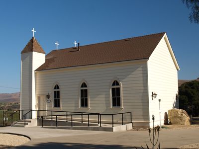
The Chapel of San Ramon is a place of worship in Santa Maria distinguished by a white wooden structure with two steeples and crosses positioned along Foxen Canyon Road. The building features a simple yet recognizable design that blends into the rural landscape of the region.

History

Frederick and Ramona Foxen Wickenden built the chapel in 1875, marking a shift in local architecture away from older mission structures. The construction symbolized the growing influence of American settlers on the religious infrastructure of the Santa Maria Valley.

Culture

The chapel honors San Ramon, a saint revered in the local community, and its white wooden structure with two steeples serves as a recognizable landmark along Foxen Canyon Road. The building reflects how early settlers expressed their faith through new architectural forms that departed from older mission traditions.

Practical

The chapel is accessed via Foxen Canyon Road in Santa Maria, where adequate parking space is available. Services are held weekly through St. Louis de Montfort Church, so visitors should check opening times beforehand if planning a visit outside of service hours.

Did you know?

Frederick Wickenden sold 5,000 sheep to finance the redwood materials required to build this chapel. This unusual funding method shows the resource scarcity and commitment early settlers had to establishing their places of worship.

GPS coordinates
34.84780,-120.24100
Latest update
December 14, 2025 18:00

AroundUs brings together thousands of curated places, local tips, and hidden gems, enriched daily by 60,000 contributors worldwide. Discover all places nearby (Santa Barbara County).

Around this place
Neverland Ranch
United States of America

Neverland Ranch

18 km
Rancho del Cielo
United States of America

Rancho del Cielo

38.4 km
Mission Santa Inés
United States of America

Mission Santa Inés

29.8 km
Guadalupe-Nipomo Dunes
United States of America

Guadalupe-Nipomo Dunes

40 km
Gaviota State Park
United States of America

Gaviota State Park

39.8 km
Nojoqui Falls
United States of America

Nojoqui Falls

36.1 km
Figueroa Mountain
United States of America

Figueroa Mountain

26.1 km
San Rafael Wilderness
United States of America

San Rafael Wilderness

34.8 km
Point Sal State Beach
United States of America

Point Sal State Beach

37.6 km
OstrichLand USA
United States of America

OstrichLand USA

27.4 km
Guadalupe-Nipomo Dunes National Wildlife Refuge
United States of America

Guadalupe-Nipomo Dunes National Wildlife Refuge

38.2 km
Twitchell Reservoir
United States of America

Twitchell Reservoir

18.7 km
Lake Cachuma
United States of America

Lake Cachuma

37.6 km
La Purisima Mission
United States of America

La Purisima Mission

25.7 km
Solvang Vintage Motorcycle Museum
United States of America

Solvang Vintage Motorcycle Museum

29.5 km
Dana Adobe
United States of America

Dana Adobe

28.9 km
Vandenberg Space Force Base Space Launch Complex 10
United States of America

Vandenberg Space Force Base Space Launch Complex 10

36.1 km
Gaviota Peak
United States of America

Gaviota Peak

38.7 km
Los Alamos Ranch House
United States of America

Los Alamos Ranch House

12.9 km
Arroyo Grande IOOF Hall
United States of America

Arroyo Grande IOOF Hall

43.3 km
Elverhøj Museum of History and Art
United States of America

Elverhøj Museum of History and Art

29.9 km
Ken Brown Wines
United States of America

Ken Brown Wines

26.2 km
Solvang Park
United States of America

Solvang Park

29.5 km
Espada Bluff
United States of America

Espada Bluff

43.6 km
Gaviota Beach
United States of America

Gaviota Beach

42 km
Solvang Festival Theater
United States of America

Solvang Festival Theater

29.7 km
Zaca Creek Bridge No. 1
United States of America

Zaca Creek Bridge No. 1

22.1 km
Zaca Creek Bridge No. 2
United States of America

Zaca Creek Bridge No. 2

22.8 km
Show the full map
« Chapel of San Ramon - Religious chapel in Santa Maria, Santa Barbara County, United States » is provided by Around Us (aroundus.com). Images and texts are derived from Wikimedia project under a Creative Commons license. You are allowed to copy, distribute, and modify copies of this page, under the conditions set by the license, as long as this note is clearly visible.

Discover hidden gems everywhere you go!

From secret cafés to breathtaking viewpoints, skip the crowded tourist spots and find places that match your style. Our app makes it easy with voice search, smart filtering, route optimization, and insider tips from travelers worldwide. Download now for the complete mobile experience.

Around Us App Screenshot

A unique approach to discovering new places

Le Figaro

All the places worth exploring

France Info

A tailor-made excursion in just a few clicks

20 Minutes

Around Us
Travel Guide & Maps
Download

Send to your phone

QR Code
1

Open the camera app on your mobile.

2

Point at the QR code with your camera. A notification will appear.

3

Tap the notification to open the link.