Enable Location

We need your location to show you interesting places around you

Discover nearby places

Find interesting locations and hidden gems around you

Precise directions

Get accurate directions and distances to places

Your location is never shared with other users. It's only used when you tap the location button.

Gaviota Peak

Log in to your account

Start exploring — it's free

Trusted by 61,362 travelers worldwide

Continue with Google
Continue with Apple
or

We will send you a code to connect

By continuing, you accept our Terms and Conditions and our Privacy Policy

Check your inbox

We've sent a pincode in your inbox. Please enter the code below.

Gaviota Peak

Gaviota Peak, Mountain summit in Santa Barbara County, California, US.

Description

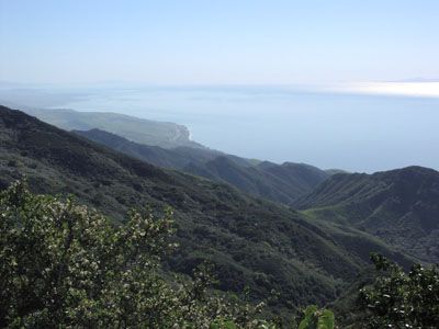
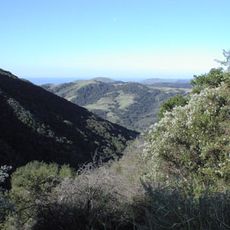
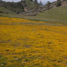
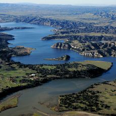
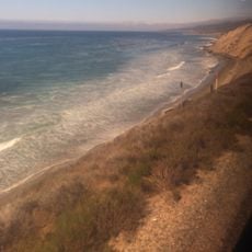
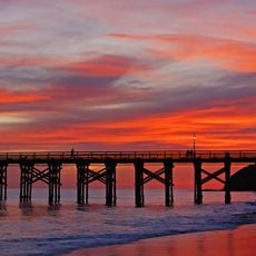
Gaviota Peak is a mountain summit in Santa Barbara County that rises to about 2,450 feet above sea level, offering panoramic views of the Pacific coast, Channel Islands, and inland valleys from its top. The peak can be reached via established hiking trails that pass through oak woodlands and chaparral vegetation.

History

The mountain area served as a hunting and gathering ground for the Chumash people, who inhabited the California coast for thousands of years before European contact. The peak remains part of the region's natural heritage today.

Culture

The mountain features two distinct trails, the Gaviota Peak Trail and Trespass Trail, which demonstrate different approaches to mountain access and preservation.

Practical

The hike to the summit takes several hours round trip and involves a moderate to steep climb with significant elevation gain. Visitors should bring plenty of water and sun protection, especially on warmer days when the exposed trail offers little shade.

Did you know?

The peak sits just a few kilometers from the Pacific Ocean, creating a rare geographic pairing where hikers can see both ocean and inland landscapes in the same view. This closeness to the coast makes it a distinctive spot for experiencing California's varied terrain compressed into one vantage point.

Location
GPS coordinates
34.50182,-120.19879
Latest update
December 14, 2025 11:21

AroundUs brings together thousands of curated places, local tips, and hidden gems, enriched daily by 60,000 contributors worldwide. Discover all places nearby (California).

Around this place
Neverland Ranch
United States of America

Neverland Ranch

28.9 km
Rancho del Cielo
United States of America

Rancho del Cielo

11.7 km
Mission Santa Inés
United States of America

Mission Santa Inés

11.8 km
United States of America

Offshore oil and gas in California

29.6 km
Refugio State Beach
United States of America

Refugio State Beach

12.4 km
Gaviota State Park
United States of America

Gaviota State Park

3.1 km
Nojoqui Falls
United States of America

Nojoqui Falls

3.8 km
El Capitán State Beach
United States of America

El Capitán State Beach

16.7 km
Harder Stadium
United States of America

Harder Stadium

32.9 km
UC Santa Barbara Events Center
United States of America

UC Santa Barbara Events Center

33.4 km
Figueroa Mountain
United States of America

Figueroa Mountain

33.3 km
Las Cumbres Observatory Global Telescope Network
United States of America

Las Cumbres Observatory Global Telescope Network

31.8 km
Point Conception Light
United States of America

Point Conception Light

25.7 km
OstrichLand USA
United States of America

OstrichLand USA

11.9 km
Lake Cachuma
United States of America

Lake Cachuma

22.1 km
Stow House
United States of America

Stow House

32.6 km
La Purisima Mission
United States of America

La Purisima Mission

27.7 km
Solvang Vintage Motorcycle Museum
United States of America

Solvang Vintage Motorcycle Museum

11.9 km
South Coast Railroad Museum
United States of America

South Coast Railroad Museum

32.4 km
Los Alamos Ranch House
United States of America

Los Alamos Ranch House

30.1 km
Elverhøj Museum of History and Art
United States of America

Elverhøj Museum of History and Art

11.3 km
Ken Brown Wines
United States of America

Ken Brown Wines

12.6 km
Solvang Park
United States of America

Solvang Park

11.8 km
Espada Bluff
United States of America

Espada Bluff

29.9 km
Gaviota Beach
United States of America

Gaviota Beach

4.2 km
Solvang Festival Theater
United States of America

Solvang Festival Theater

11.6 km
Zaca Creek Bridge No. 1
United States of America

Zaca Creek Bridge No. 1

17.1 km
Zaca Creek Bridge No. 2
United States of America

Zaca Creek Bridge No. 2

16.4 km
Show the full map
« Gaviota Peak - Mountain summit in Santa Barbara County, California, US » is provided by Around Us (aroundus.com). Images and texts are derived from Wikimedia project under a Creative Commons license. You are allowed to copy, distribute, and modify copies of this page, under the conditions set by the license, as long as this note is clearly visible.

Discover hidden gems everywhere you go!

From secret cafés to breathtaking viewpoints, skip the crowded tourist spots and find places that match your style. Our app makes it easy with voice search, smart filtering, route optimization, and insider tips from travelers worldwide. Download now for the complete mobile experience.

Around Us App Screenshot

A unique approach to discovering new places

Le Figaro

All the places worth exploring

France Info

A tailor-made excursion in just a few clicks

20 Minutes

Around Us
Travel Guide & Maps
Download

Send to your phone

QR Code
1

Open the camera app on your mobile.

2

Point at the QR code with your camera. A notification will appear.

3

Tap the notification to open the link.