Enable Location

We need your location to show you interesting places around you

Discover nearby places

Find interesting locations and hidden gems around you

Precise directions

Get accurate directions and distances to places

Your location is never shared with other users. It's only used when you tap the location button.

Lake Cachuma

Log in to your account

Start exploring — it's free

Trusted by 62,131 travelers worldwide

Continue with Google
Continue with Apple
or

We will send you a code to connect

By continuing, you accept our Terms and Conditions and our Privacy Policy

Check your inbox

We've sent a pincode in your inbox. Please enter the code below.

Lake Cachuma

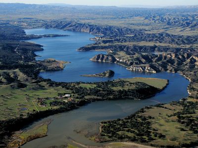
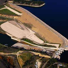
Lake Cachuma, reservoir in Santa Barbara County, California

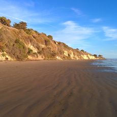
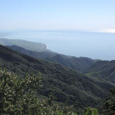
Lake Cachuma is a large reservoir in Santa Barbara County, California, held back by an earthen dam that spans across the Santa Ynez River. The water is surrounded by gentle hills, native vegetation, and trees that support wildlife including deer, birds of prey, and waterfowl.

The lake was created in 1953 when the Bradbury Dam was completed across the Santa Ynez River. This project was built to store water for the region and provide a reliable supply during dry seasons for local agriculture and communities.

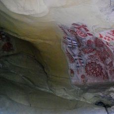
The name Cachuma comes from the Chumash language, reflecting the indigenous people who lived in this region long ago. Visitors today experience this connection as they explore the shoreline and see how the landscape shaped the lives of those who came before.

The lake is open year-round for fishing and boating, with docks and boat ramps available for visitors with vessels. Swimming and water skiing are not permitted to protect the water quality for drinking, though kayaks and small boats are welcome with proper safety precautions.

The lake serves as a training ground for the University of California, Santa Barbara rowing team, which maintains a boathouse near the water for its athletes. Visitors often spot bald eagles perching in trees around the shoreline and soaring over the water during observation tours.

The community of curious travelers

AroundUs brings together thousands of curated places, local tips, and hidden gems, enriched daily by 60,000 contributors worldwide.

Start exploring
GPS coordinates
34.58666,-119.98098
Latest update
February 7, 2026 11:40
Around this place
Neverland Ranch
United States of America

Neverland Ranch

20.2 km
Rancho del Cielo
United States of America

Rancho del Cielo

10.7 km
Mission Santa Inés
United States of America

Mission Santa Inés

14.3 km
Knapp's Castle
United States of America

Knapp's Castle

18.6 km
Chumash Painted Cave State Historic Park
United States of America

Chumash Painted Cave State Historic Park

20 km
Refugio State Beach
United States of America

Refugio State Beach

16.2 km
Nojoqui Falls
United States of America

Nojoqui Falls

18.7 km
El Capitán State Beach
United States of America

El Capitán State Beach

14.6 km
Harder Stadium
United States of America

Harder Stadium

21.9 km
Cold Spring Canyon Arch Bridge
United States of America

Cold Spring Canyon Arch Bridge

15 km
Figueroa Mountain
United States of America

Figueroa Mountain

17.4 km
Las Cumbres Observatory Global Telescope Network
United States of America

Las Cumbres Observatory Global Telescope Network

20.3 km
OstrichLand USA
United States of America

OstrichLand USA

18.1 km
Stow House
United States of America

Stow House

20 km
Solvang Vintage Motorcycle Museum
United States of America

Solvang Vintage Motorcycle Museum

14.5 km
Bradbury Dam
United States of America

Bradbury Dam

429 m
Gaviota Peak
United States of America

Gaviota Peak

22.1 km
South Coast Railroad Museum
United States of America

South Coast Railroad Museum

19.9 km
Little Pine Mountain
United States of America

Little Pine Mountain

22.2 km
Elverhøj Museum of History and Art
United States of America

Elverhøj Museum of History and Art

14.9 km
El Capitan Beach
United States of America

El Capitan Beach

14.7 km
Sands Beach
United States of America

Sands Beach

21.8 km
Solvang Park
United States of America

Solvang Park

14.6 km
Solvang Festival Theater
United States of America

Solvang Festival Theater

14.7 km
El Capitan Beach
United States of America

El Capitan Beach

14.8 km
Devereux Beach
United States of America

Devereux Beach

22.2 km
Refugio Beach
United States of America

Refugio Beach

16 km
Zaca Creek Bridge No. 1
United States of America

Zaca Creek Bridge No. 1

20 km
Show the full map
« Lake Cachuma - reservoir in Santa Barbara County, California » is provided by Around Us (aroundus.com). Images and texts are derived from Wikimedia project under a Creative Commons license. You are allowed to copy, distribute, and modify copies of this page, under the conditions set by the license, as long as this note is clearly visible.

Discover hidden gems everywhere you go!

From secret cafés to breathtaking viewpoints, skip the crowded tourist spots and find places that match your style. Our app makes it easy with voice search, smart filtering, route optimization, and insider tips from travelers worldwide. Download now for the complete mobile experience.

Around Us App Screenshot

A unique approach to discovering new places

Le Figaro

All the places worth exploring

France Info

A tailor-made excursion in just a few clicks

20 Minutes

Around Us
Travel Guide & Maps
Download

Send to your phone

QR Code
1

Open the camera app on your mobile.

2

Point at the QR code with your camera. A notification will appear.

3

Tap the notification to open the link.