Enable Location

We need your location to show you interesting places around you

Discover nearby places

Find interesting locations and hidden gems around you

Precise directions

Get accurate directions and distances to places

Your location is never shared with other users. It's only used when you tap the location button.

Cold Spring Canyon Arch Bridge

Log in to your account

Start exploring — it's free

Trusted by travelers worldwide

Continue with Google
Continue with Apple
or

We will send you a code to connect

By continuing, you accept our Terms and Conditions and our Privacy Policy

Check your inbox

We've sent a pincode in your inbox. Please enter the code below.

Cold Spring Canyon Arch Bridge

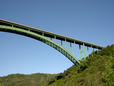
Cold Spring Canyon Arch Bridge, Steel arch road bridge in Santa Ynez Mountains, US.

Description

Cold Spring Canyon Arch Bridge is a steel arch road bridge crossing the Santa Ynez Mountains, connecting Santa Barbara with the Santa Ynez Valley via State Route 154. The structure spans the canyon at considerable height using distinctive arches that cross the entire valley width.

History

The bridge was completed in 1964 and combined steel construction techniques from American Bridge Company with innovative design solutions for steep mountain terrain. It later earned recognition as a Historic Civil Engineering Landmark for its engineering significance.

Culture

The location sits near Cold Spring Tavern, a former stagecoach stop from the 1800s, which reflects how transportation evolved in California's mountain regions. The bridge stands as a symbol connecting isolated communities and shows how engineering made settling these areas possible.

Practical

Visitors can view the bridge from Stagecoach Road, which has designated stopping and photography areas along the route. Planning your visit around daylight hours helps capture the structure from different angles safely.

Did you know?

A distinctive safety feature is the protective mesh barrier installed to prevent falls, which remains largely unnoticed by regular road users. The measure has become an integral part of the structure while maintaining the bridge's visual appearance.

Inception
1963
Official opening
1963
GPS coordinates
34.52610,-119.83500
Latest update
December 8, 2025 19:56

AroundUs brings together thousands of curated places, local tips, and hidden gems, enriched daily by 60,000 contributors worldwide. Discover all places nearby (Santa Barbara County).

Around this place
Mission Santa Barbara
United States of America

Mission Santa Barbara

14.8 km
Knapp's Castle
United States of America

Knapp's Castle

3.9 km
Chumash Painted Cave State Historic Park
United States of America

Chumash Painted Cave State Historic Park

5 km
Harder Stadium
United States of America

Harder Stadium

11.9 km
Santa Barbara Museum of Natural History
United States of America

Santa Barbara Museum of Natural History

14.6 km
Arroyo Burro Beach
United States of America

Arroyo Burro Beach

16 km
Las Cumbres Observatory Global Telescope Network
United States of America

Las Cumbres Observatory Global Telescope Network

10.7 km
Storke Tower
United States of America

Storke Tower

12.7 km
Santa Barbara Botanic Garden
United States of America

Santa Barbara Botanic Garden

14.1 km
Lake Cachuma
United States of America

Lake Cachuma

15 km
Gibraltar Dam
United States of America

Gibraltar Dam

13.6 km
Goleta Beach
United States of America

Goleta Beach

12.4 km
Stow House
United States of America

Stow House

9.4 km
La Cumbre Peak
United States of America

La Cumbre Peak

11.8 km
Bradbury Dam
United States of America

Bradbury Dam

14.8 km
Art, Design & Architecture Museum
United States of America

Art, Design & Architecture Museum

12.8 km
Bren Hall
United States of America

Bren Hall

12.7 km
Joseph and Lucy Foster Sexton House
United States of America

Joseph and Lucy Foster Sexton House

10.2 km
South Coast Railroad Museum
United States of America

South Coast Railroad Museum

9.5 km
Santa Barbara Mission-Archive Library
United States of America

Santa Barbara Mission-Archive Library

14.8 km
Thomas Hope House
United States of America

Thomas Hope House

11.7 km
Little Pine Mountain
United States of America

Little Pine Mountain

12.1 km
Sands Beach
United States of America

Sands Beach

13.7 km
Rocky Nook Park
United States of America

Rocky Nook Park

14.7 km
Hope Ranch Private Beach
United States of America

Hope Ranch Private Beach

13.7 km
A.C. Postel Memorial Rose Garden
United States of America

A.C. Postel Memorial Rose Garden

15 km
Rattlesnake Canyon Bridge
United States of America

Rattlesnake Canyon Bridge

15.2 km
Devereux Beach
United States of America

Devereux Beach

13.6 km
Show the full map
« Cold Spring Canyon Arch Bridge - Steel arch road bridge in Santa Ynez Mountains, US » is provided by Around Us (aroundus.com). Images and texts are derived from Wikimedia project under a Creative Commons license. You are allowed to copy, distribute, and modify copies of this page, under the conditions set by the license, as long as this note is clearly visible.

Discover hidden gems everywhere you go!

From secret cafés to breathtaking viewpoints, skip the crowded tourist spots and find places that match your style. Our app makes it easy with voice search, smart filtering, route optimization, and insider tips from travelers worldwide. Download now for the complete mobile experience.

Around Us App Screenshot

A unique approach to discovering new places

Le Figaro

All the places worth exploring

France Info

A tailor-made excursion in just a few clicks

20 Minutes

Around Us
Travel Guide & Maps
Download

Send to your phone

QR Code
1

Open the camera app on your mobile.

2

Point at the QR code with your camera. A notification will appear.

3

Tap the notification to open the link.