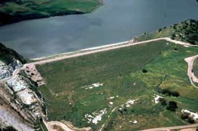
Twitchell Reservoir, reservoir in the United States
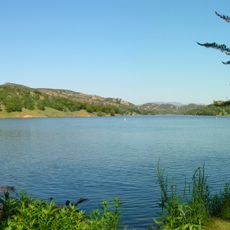
Twitchell Reservoir is a man-made water basin in the Santa Maria Valley of Santa Barbara County, California, formed by a dam built across the Cuyama River. The basin collects winter runoff and releases it gradually to recharge underground aquifers and reduce flood risk downstream.
The dam was built in the late 1950s by the Bureau of Reclamation as part of a federal effort to control flooding and secure water for agriculture in this dry part of California. It was named after T.A. Twitchell, a local figure who supported the project.
The reservoir sits at the center of a farming region where water is the most precious resource and its management shapes daily life. Locals depend on the groundwater it helps replenish to sustain agriculture across the Santa Maria Valley.
The dam and the water's edge are not open to the public, as the area is managed by government agencies. Nearby rural roads offer views of the basin and the surrounding countryside without requiring any access permit.
The reservoir was not built to store drinking water directly but to let water seep slowly into the ground and refill natural underground reserves. This means that seeing the basin nearly empty does not signal a problem but rather that the system is working as intended.
The community of curious travelers
AroundUs brings together thousands of curated places, local tips, and hidden gems, enriched daily by 60,000 contributors worldwide.