Balmy Alley

Log in to your account

AroundUs is a community-driven map of interesting places, built by curious explorers like you. It grows with every review, story, and photo you share.
Connect to save your favorite spots, contribute locations, and create personalized routes.
By continuing, you accept our Terms and Conditions and our Privacy Policy
Add to collection
Map
Suggest a change
Share

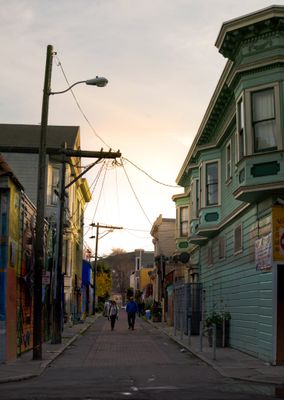
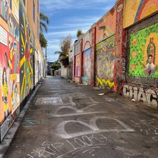
Balmy Alley, Street art corridor in Mission District, San Francisco, US.

Balmy Alley is a narrow passageway in the Mission District lined with painted walls and garage doors. The murals cover every available surface with large colorful images created over several decades.

Painting began in the 1970s when local artists started adding their work to the alley walls. The project has continued growing with fresh murals regularly added to reflect current social issues.

The murals serve as a visual record of the Latin American community's presence and struggles in this neighborhood. Visitors encounter the works as an ongoing conversation about justice and identity that continues to evolve with new paintings.

The alley is easily accessible and can be explored on foot by visitors of all abilities. It is best visited early in the morning or on weekdays when crowds are smaller.

The artists paint without official permission and frequently repaint their own work, keeping the alley constantly changing. This means no two visits are exactly the same, as new images appear and transform regularly.

Location: San Francisco

GPS coordinates: 37.75180,-122.41200

Latest update: December 8, 2025 19:43

Photos
Sites and monuments of San Francisco: Golden Gate Bridge, Alcatraz and Victorian architecture

San Francisco brings together historical monuments and natural sites that reflect the city's unique history and geography. The Golden Gate Bridge, a 2,737-meter-long suspension bridge completed in 1937, is one of the region's most recognizable structures. Alcatraz Island, a former high-security federal prison operating from 1934 to 1963, is located in the bay and is visited by ferry. The Painted Ladies, seven Victorian houses built between 1892 and 1896, exemplify San Francisco’s characteristic residential architecture with their colorful facades facing Alamo Square Park. The city also includes Fisherman's Wharf, a historic port district developed from late 19th-century Italian fishing piers, and the Fillmore, a performance hall from the 1910s that contributed to the development of the West Coast music scene. Twin Peaks provide viewpoints at 928 feet (283 meters), while Lands End features rocky cliffs and hiking trails at the western tip of the peninsula. The Cable Cars, a mechanical transportation system operating since 1873, run on three lines through San Francisco's sloped streets.

Around this place
Show the full map
Mission San Francisco de Asís
United States of America

Mission San Francisco de Asís

1.9 km
Seals Stadium
United States of America

Seals Stadium

1.7 km
Mission Dolores Park
United States of America

Mission Dolores Park

1.5 km
Clarion Alley
United States of America

Clarion Alley

1.5 km
Woodward's Gardens
United States of America

Woodward's Gardens

2 km
Roxie Cinema
United States of America

Roxie Cinema

1.7 km
Bernal Heights Summit
United States of America

Bernal Heights Summit

1 km
Potrero Point
United States of America

Potrero Point

1.2 km
The Deaf Club
United States of America

The Deaf Club

1.6 km
Redstone Building
United States of America

Redstone Building

1.6 km
Alamo Drafthouse New Mission Cinema
United States of America

Alamo Drafthouse New Mission Cinema

795 m
Victoria Theatre
United States of America

Victoria Theatre

1.6 km
San Francisco Eagle
United States of America

San Francisco Eagle

2 km
Kadist Art Foundation
United States of America

Kadist Art Foundation

809 m
Potrero Hill Neighborhood House
United States of America

Potrero Hill Neighborhood House

1.2 km
Minnesota Street Project
United States of America

Minnesota Street Project

2 km
Artists' Television Access
United States of America

Artists' Television Access

1 km
Girls Club
United States of America

Girls Club

1.1 km
Trinity Presbyterian Church
United States of America

Trinity Presbyterian Church

1.7 km
Second Church of Christ, Scientist
United States of America

Second Church of Christ, Scientist

1.4 km
St. Matthew’s Lutheran Church
United States of America

St. Matthew’s Lutheran Church

1.9 km
Frank G. Edwards House
United States of America

Frank G. Edwards House

1 km
Maxime Leforestier's blue house
United States of America

Maxime Leforestier's blue house

1.8 km
Bernal Heights Branch Library
United States of America

Bernal Heights Branch Library

1.5 km
Maison bleue, San Francisco
United States of America

Maison bleue, San Francisco

1.8 km
Mission Branch Library
United States of America

Mission Branch Library

695 m
Potrero Branch Library
United States of America

Potrero Branch Library

1.6 km
Liberty Street Historic District
United States of America

Liberty Street Historic District

1.2 km
Show the full map
Reviews

Visited this place? Tap the stars to rate it and share your experience / photos with the community! Try now! You can cancel it anytime.

« Balmy Alley - Street art corridor in Mission District, San Francisco, US » is provided by Around Us (aroundus.com). Images and texts are derived from Wikimedia project under a Creative Commons license. You are allowed to copy, distribute, and modify copies of this page, under the conditions set by the license, as long as this note is clearly visible.

Discover hidden gems everywhere you go!

From secret cafés to breathtaking viewpoints, skip the crowded tourist spots and find places that match your style. Our app makes it easy with voice search, smart filtering, route optimization, and insider tips from travelers worldwide. Download now for the complete mobile experience.

Around Us App Screenshot

A unique approach to discovering new places

Le Figaro

All the places worth exploring

France Info

A tailor-made excursion in just a few clicks

20 Minutes