Fort Funston

Log in to your account

AroundUs is a community-driven map of interesting places, built by curious explorers like you. It grows with every review, story, and photo you share.
Connect to save your favorite spots, contribute locations, and create personalized routes.
Continue with Google
Continue with Apple
Continue with X
Continue with Facebook
Continue with email
By continuing, you accept our Terms and Conditions and our Privacy Policy
Create an account
Add to collection
Map
Suggest a change
Share

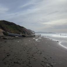
Fort Funston, Coastal bluffs in San Francisco, United States.

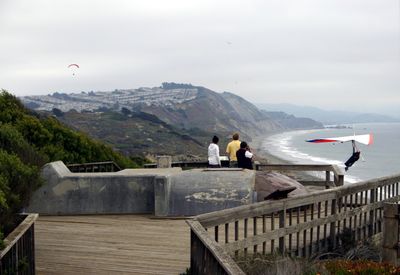
Fort Funston is a coastal protection area and wildlife refuge featuring high sandy cliffs above the Pacific Ocean with natural dune systems spreading across the landscape. The site includes winding trails and historic military structures embedded in the terrain.

This coastal site was developed as a military fortification in the early 1900s to defend California's shoreline during world conflicts. Following the end of military operations, it transitioned into a protected nature area under the Golden Gate Recreation Area system.

The site bears the name of a military officer and retains visible remnants of its defense installations from decades past. These structures shape how visitors experience the landscape today and serve as physical reminders of the coast's strategic importance.

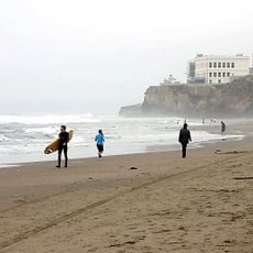
Parking areas along Skyline Boulevard provide the main access point to the grounds, with facilities like restrooms and picnic tables available. The exposed bluffs and open terrain can be visited year-round, though wind and fog are common conditions to prepare for.

The location attracts people who fly hang gliders due to its powerful and consistent winds coming off the ocean. These steady air currents have become an unexpected draw for visitors seeking thrilling sports activities alongside nature observation.

Location: San Francisco

Operator: National Park Service

Part of: Golden Gate National Recreation Area

Website: https://nps.gov/goga/planyourvisit/fortfunston.htm

GPS coordinates: 37.71500,-122.50200

Latest update: December 7, 2025 10:07

Photos
Around this place
Olympic Club
United States of America

Olympic Club

909 m
TPC Harding Park
United States of America

TPC Harding Park

1.3 km
San Francisco Zoo
United States of America

San Francisco Zoo

2.1 km
Ocean Beach
United States of America

Ocean Beach

5 km
Sigmund Stern Recreation Grove
United States of America

Sigmund Stern Recreation Grove

3.1 km
16th Avenue Tiled Steps
United States of America

16th Avenue Tiled Steps

5.2 km
Boxer Stadium
United States of America

Boxer Stadium

5.2 km
Westlake Shopping Center
United States of America

Westlake Shopping Center

2.6 km
Thornton State Beach
United States of America

Thornton State Beach

3.5 km
Murphy Windmill
United States of America

Murphy Windmill

5.5 km
Mother's Building
United States of America

Mother's Building

2.2 km
Trocadero, San Francisco
United States of America

Trocadero, San Francisco

3.2 km
Pine Lake Park
United States of America

Pine Lake Park

2.8 km
Congregation B’nai Israel
United States of America

Congregation B’nai Israel

3.8 km
Cayuga Park
United States of America

Cayuga Park

4.6 km
Oceanside Water Pollution Control Plant
United States of America

Oceanside Water Pollution Control Plant

1.4 km
Laguna Honda
United States of America

Laguna Honda

5.5 km
Salem Memorial Park and Garden
United States of America

Salem Memorial Park and Garden

5.6 km
Mount Davidson cross
United States of America

Mount Davidson cross

4.9 km
Ingleside Branch Library
United States of America

Ingleside Branch Library

4.1 km
Merced Branch Library
United States of America

Merced Branch Library

2.7 km
West Portal Branch Library
United States of America

West Portal Branch Library

4.3 km
Broderick-Terry Dueling Place
United States of America

Broderick-Terry Dueling Place

1.8 km
Ocean View Branch Library
United States of America

Ocean View Branch Library

3.2 km
Ortega Branch Library
United States of America

Ortega Branch Library

4 km
Parkside Branch Library
United States of America

Parkside Branch Library

3.7 km
Phillip Burton Memorial Beach
United States of America

Phillip Burton Memorial Beach

905 m
Westlake Library
United States of America

Westlake Library

2.5 km
Show the full map
Reviews

Visited this place? Tap the stars to rate it and share your experience / photos with the community! Try now! You can cancel it anytime.

« Fort Funston - Coastal bluffs in San Francisco, United States » is provided by Around Us (aroundus.com). Images and texts are derived from Wikimedia project under a Creative Commons license. You are allowed to copy, distribute, and modify copies of this page, under the conditions set by the license, as long as this note is clearly visible.

Discover hidden gems everywhere you go!

From secret cafés to breathtaking viewpoints, skip the crowded tourist spots and find places that match your style. Our app makes it easy with voice search, smart filtering, route optimization, and insider tips from travelers worldwide. Download now for the complete mobile experience.

Around Us App Screenshot

A unique approach to discovering new places

Le Figaro

All the places worth exploring

France Info

A tailor-made excursion in just a few clicks

20 Minutes