Chest opened
+${chestReward.xp} XP
Explorer
NOUVEAU ×${chestReward.collectible.quantity}
tapez pour fermer
Chest locked

Open chests in the app

Around Us is built for your phone — chests unlock when you walk, explore and capture nearby places.

Enable Location

We need your location to show you interesting places around you

Discover nearby places

Find interesting locations and hidden gems around you

Precise directions

Get accurate directions and distances to places

Your location is never shared with other users. It's only used when you tap the location button.

Log in to your account

Start exploring — it's free

Trusted by 72,993 travelers worldwide

Continue with Google
Continue with Apple
or

We will send you a code to connect

By continuing, you accept our Terms and Conditions and our Privacy Policy

Check your inbox

We've sent a pincode in your inbox. Please enter the code below.

Bonny Doon Ecological Reserve
Discussion Reviews Photo
4.5k Popularity

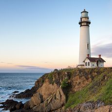
Bonny Doon Ecological Reserve, Protected ecological reserve in Santa Cruz Mountains, California.

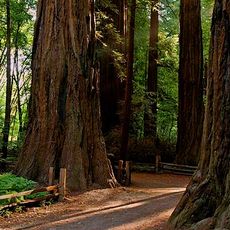
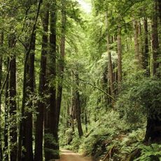
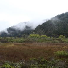
Bonny Doon Ecological Reserve is a protected area in the Santa Cruz Mountains of California. The land holds several distinct plant communities side by side, from ponderosa pine and redwood forest to chaparral and open grassland, each growing in its own section of the terrain.

The Nature Conservancy bought the land in 1989 and then passed it to the state of California. Four years later, in 1993, the Fish and Game Commission gave it the official status of an ecological reserve.

The Santa Cruz Sandhills at the heart of this reserve have a pale, sandy soil that looks almost out of place among the surrounding forest. Visitors walking through the open sections can clearly see how this unusual ground shapes what grows there and what does not.

The reserve is only reachable by car: take Bonny Doon Road East from Highway 1, then turn onto Martin Road and park near the fire station. Allow extra time to move between sections, as the different plant communities are spread across a wider area and walking between them takes a while.

The Zayante soils here are so unlike other soils in the region that they support plants found nowhere else nearby, including the Bonny Doon manzanita and the Ben Lomond spineflower. Both species depend on these exact ground conditions and cannot survive outside this small pocket of land.

The community of curious travelers

AroundUs brings together thousands of curated places, local tips, and hidden gems, enriched daily by 60,000 contributors worldwide.

Start exploring
Location
GPS coordinates
37.07110,-122.25100
Latest update
March 3, 2026 10:06
Around this place
Big Basin Redwoods State Park
United States of America

Big Basin Redwoods State Park

11.6 km
Pigeon Point Lighthouse
United States of America

Pigeon Point Lighthouse

17.7 km
Henry Cowell Redwoods State Park
United States of America

Henry Cowell Redwoods State Park

18.9 km
Año Nuevo State Park
United States of America

Año Nuevo State Park

10 km
Roaring Camp and Big Trees Narrow Gauge Railroad
United States of America

Roaring Camp and Big Trees Narrow Gauge Railroad

17.1 km
Skyline-to-the-Sea Trail
United States of America

Skyline-to-the-Sea Trail

11.7 km
Wilder Ranch State Park
United States of America

Wilder Ranch State Park

16.6 km
Butano State Park
United States of America

Butano State Park

16.7 km
Año Nuevo Island
United States of America

Año Nuevo Island

8.8 km
Natural Bridges State Marine Reserve
United States of America

Natural Bridges State Marine Reserve

16.4 km
College Eight
United States of America

College Eight

18.8 km
Felton Covered Bridge
United States of America

Felton Covered Bridge

16.2 km
McHenry Library
United States of America

McHenry Library

19 km
Coast Dairies
United States of America

Coast Dairies

5.7 km
Arboretum at the University of California, Santa Cruz
United States of America

Arboretum at the University of California, Santa Cruz

19.5 km
California Powder Works Bridge
United States of America

California Powder Works Bridge

19.6 km
Tip Toe Falls
United States of America

Tip Toe Falls

20 km
Bigfoot Discovery Museum
United States of America

Bigfoot Discovery Museum

16.2 km
Grace Episcopal Church
United States of America

Grace Episcopal Church

12.6 km
Theodore J. Hoover Natural Preserve
United States of America

Theodore J. Hoover Natural Preserve

3.7 km
Felton Presbyterian Church
United States of America

Felton Presbyterian Church

15.9 km
Rancho Del Oso Nature and History Center
United States of America

Rancho Del Oso Nature and History Center

3.6 km
Headquarters Administration Building
United States of America

Headquarters Administration Building

11.6 km
Visitor Center | Henry Cowell Redwoods State Park
United States of America

Visitor Center | Henry Cowell Redwoods State Park

17 km
Felton Presbyterian Church
United States of America

Felton Presbyterian Church

15.9 km
Ano Nuevo light station
United States of America

Ano Nuevo light station

8.8 km
Shark Fin Cove (California)
United States of America

Shark Fin Cove (California)

9.5 km
Panther Beach
United States of America

Panther Beach

11.3 km
Show the full map
Reviews
Share your experience

No review yet

Discussions
Start a discussion...

No discussion yet

« Bonny Doon Ecological Reserve - Protected ecological reserve in Santa Cruz Mountains, California » is provided by Around Us (aroundus.com). Images and texts are derived from Wikimedia project under a Creative Commons license. You are allowed to copy, distribute, and modify copies of this page, under the conditions set by the license, as long as this note is clearly visible.

Discover hidden gems everywhere you go!

From secret cafés to breathtaking viewpoints, skip the crowded tourist spots and find places that match your style. Our app makes it easy with voice search, smart filtering, route optimization, and insider tips from travelers worldwide. Download now for the complete mobile experience.

Around Us App Screenshot

A unique approach to discovering new places

Le Figaro

All the places worth exploring

France Info

A tailor-made excursion in just a few clicks

20 Minutes

Around Us
Travel Guide & Maps
Download

Send to your phone

QR Code
1

Open the camera app on your mobile.

2

Point at the QR code with your camera. A notification will appear.

3

Tap the notification to open the link.