Enable Location

We need your location to show you interesting places around you

Discover nearby places

Find interesting locations and hidden gems around you

Precise directions

Get accurate directions and distances to places

Your location is never shared with other users. It's only used when you tap the location button.

Alum Rock Park

Log in to your account

Start exploring — it's free

Trusted by 61,319 travelers worldwide

Continue with Google
Continue with Apple
or

We will send you a code to connect

By continuing, you accept our Terms and Conditions and our Privacy Policy

Check your inbox

We've sent a pincode in your inbox. Please enter the code below.

Alum Rock Park, Urban park in Alum Rock district, San Jose, US

Description

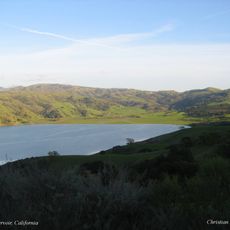
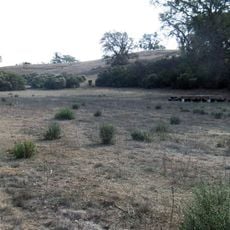
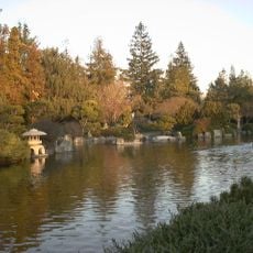
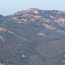
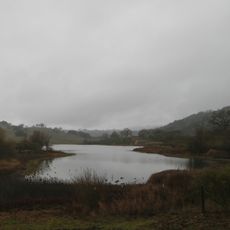
Alum Rock Park covers 720 acres (290 hectares) and contains oak woodlands, grasslands, and creek corridors with 13 miles (21 kilometers) of pathways winding through changing terrain. The routes pass through shaded canyons and open hillsides where views of the Santa Clara Valley appear between the trees.

History

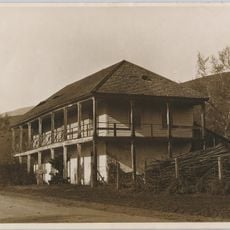
The city established the grounds in 1872 as a public retreat after a health resort drawing visitors from across the valley opened around mineral springs. A narrow-gauge railway connected the canyon to downtown San Jose from 1890, carrying guests to the bathhouses and picnic areas.

Culture

Indigenous communities called the stream Shistuk, while Spanish colonists named it Aguague, marking the layers of settlement in this valley. Hikers today follow the same watercourse paths once traveled by native groups gathering acorns and medicinal plants.

Practical

Visitors find picnic sites with grills, playgrounds, and restrooms at several points along the main road through the park. Early morning or late afternoon offers cooler conditions for hiking, especially during summer months.

Did you know?

White deposits near the entrance were misidentified as alum when they are actually different minerals, but the name stuck anyway. The spring that once drew bathers still flows at the same spot, though the bathhouses disappeared long ago.

Location
Location
Inception
1872
GPS coordinates
37.39770,-121.80000
Latest update
December 5, 2025 22:31

AroundUs brings together thousands of curated places, local tips, and hidden gems, enriched daily by 60,000 contributors worldwide. Discover all places nearby (California).

Around this place
San José State University
United States of America

San José State University

10 km
Happy Hollow Park & Zoo
United States of America

Happy Hollow Park & Zoo

9.7 km
San Jose Flea Market
United States of America

San Jose Flea Market

7.7 km
Gurdwara Sahib of San Jose
United States of America

Gurdwara Sahib of San Jose

8.5 km
Calaveras Reservoir
United States of America

Calaveras Reservoir

9.2 km
The Jungle
United States of America

The Jungle

9.6 km
Viet Museum
United States of America

Viet Museum

10.1 km
Japanese American Museum of San Jose
United States of America

Japanese American Museum of San Jose

10 km
Portuguese Historical Museum
United States of America

Portuguese Historical Museum

10.1 km
Blue Oak Ranch Reserve
United States of America

Blue Oak Ranch Reserve

5.9 km
Japanese Friendship Garden
United States of America

Japanese Friendship Garden

10 km
California Trolley and Railroad Corporation
United States of America

California Trolley and Railroad Corporation

10.1 km
Eastridge Transit Center
United States of America

Eastridge Transit Center

7.8 km
Jose Maria Alviso Adobe
United States of America

Jose Maria Alviso Adobe

7.9 km
Black Mountain
United States of America

Black Mountain

9.8 km
Our Lady of Guadalupe Church
United States of America

Our Lady of Guadalupe Church

6.4 km
Raging Waters
United States of America

Raging Waters

7 km
Ashworth-Remillard House
United States of America

Ashworth-Remillard House

9.3 km
Arthur Monroe Free House
United States of America

Arthur Monroe Free House

9.1 km
East San José Carnegie Branch Library
United States of America

East San José Carnegie Branch Library

8.3 km
Grant Lake
United States of America

Grant Lake

9.2 km
LEGOLAND Discovery Center
United States of America

LEGOLAND Discovery Center

8.8 km
St. Patrick Proto-Cathedral Church
United States of America

St. Patrick Proto-Cathedral Church

9.7 km
Olympic Black Power Statue
United States of America

Olympic Black Power Statue

10.1 km
Backesto Fountain
United States of America

Backesto Fountain

9.1 km
Santo Market
United States of America

Santo Market

9.9 km
Central Classroom Building
United States of America

Central Classroom Building

10 km
Robert D. Clark Hall
United States of America

Robert D. Clark Hall

10 km
Show the full map
« Alum Rock Park - Urban park in Alum Rock district, San Jose, US » is provided by Around Us (aroundus.com). Images and texts are derived from Wikimedia project under a Creative Commons license. You are allowed to copy, distribute, and modify copies of this page, under the conditions set by the license, as long as this note is clearly visible.

Discover hidden gems everywhere you go!

From secret cafés to breathtaking viewpoints, skip the crowded tourist spots and find places that match your style. Our app makes it easy with voice search, smart filtering, route optimization, and insider tips from travelers worldwide. Download now for the complete mobile experience.

Around Us App Screenshot

A unique approach to discovering new places

Le Figaro

All the places worth exploring

France Info

A tailor-made excursion in just a few clicks

20 Minutes

Around Us
Travel Guide & Maps
Download

Send to your phone

QR Code
1

Open the camera app on your mobile.

2

Point at the QR code with your camera. A notification will appear.

3

Tap the notification to open the link.