Chest opened
+${chestReward.xp} XP
Explorer
NOUVEAU ×${chestReward.collectible.quantity}
tapez pour fermer
Chest locked

Open chests in the app

Around Us is built for your phone — chests unlock when you walk, explore and capture nearby places.

Enable Location

We need your location to show you interesting places around you

Discover nearby places

Find interesting locations and hidden gems around you

Precise directions

Get accurate directions and distances to places

Your location is never shared with other users. It's only used when you tap the location button.

Gabilan Range

Log in to your account

Start exploring — it's free

Trusted by 72,886 travelers worldwide

Continue with Google
Continue with Apple
or

We will send you a code to connect

By continuing, you accept our Terms and Conditions and our Privacy Policy

Check your inbox

We've sent a pincode in your inbox. Please enter the code below.

Gabilan Range
Discussion Reviews 1 Photos
8.9k Popularity

Gabilan Range, Mountain range in Monterey County, California, US

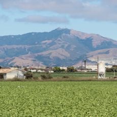
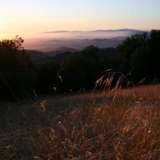
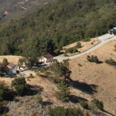
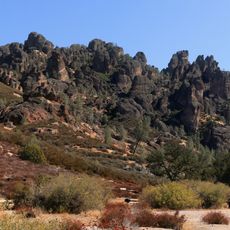
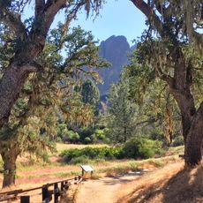
The Gabilan Range is a mountain chain extending along the border between Monterey and San Benito counties, with its highest point around 1,050 meters at Fremont Peak. The southern section contains Pinnacles National Park, featuring multiple hiking trails and varied terrain with rock formations and dry scrubland.

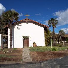
Native American tribes originally inhabited the area and used this mountain range for resources and navigation. Spanish colonizers later arrived and named it after the hawks that inhabited the mountains.

John Steinbeck featured this mountain range in his novels including 'Of Mice and Men' and 'East of Eden', embedding it into American literature. The landscape continues to inspire writers and artists who work in the region.

Multiple hiking trails of varying difficulty levels are available, and Pinnacles National Park is accessible throughout the year. The terrain is dry and exposed, so bring sun protection and plenty of water when hiking.

A critical wildlife corridor connects the Santa Cruz Mountains to this range, protected by land trust conservation efforts in the area. The Rocks Ranch preservation demonstrates how local organizations maintain animal migration pathways between different mountain regions.

The community of curious travelers

AroundUs brings together thousands of curated places, local tips, and hidden gems, enriched daily by 60,000 contributors worldwide.

Start exploring
Location
Elevation above the sea
1,053 m
GPS coordinates
36.61110,-121.31470
Latest update
December 10, 2025 15:59
Around this place
Mission Nuestra Señora de la Soledad
United States of America

Mission Nuestra Señora de la Soledad

23.3 km
Tassajara Zen Mountain Center
United States of America

Tassajara Zen Mountain Center

36.5 km
Fremont Peak
United States of America

Fremont Peak

23.5 km
National Steinbeck Center
United States of America

National Steinbeck Center

31.3 km
Fremont Peak State Park
United States of America

Fremont Peak State Park

23.5 km
San Juan Bautista State Historic Park
United States of America

San Juan Bautista State Historic Park

32.6 km
Monterey County Jail
United States of America

Monterey County Jail

31.6 km
Fremont Peak Observatory
United States of America

Fremont Peak Observatory

23.4 km
Jose Castro House
United States of America

Jose Castro House

32.6 km
Rancho Las Palmas
United States of America

Rancho Las Palmas

31.8 km
Juan de Anza House
United States of America

Juan de Anza House

32.5 km
Jose Eusebio Boronda Adobe
United States of America

Jose Eusebio Boronda Adobe

33.9 km
Monterey County Court House
United States of America

Monterey County Court House

31.5 km
Krough House
United States of America

Krough House

31.7 km
Hollister Carnegie Library
United States of America

Hollister Carnegie Library

27.8 km
Pinnacles National Forest
United States of America

Pinnacles National Forest

16.1 km
Sheriff William Joseph Nesbitt House
United States of America

Sheriff William Joseph Nesbitt House

31.8 km
Rozas House
United States of America

Rozas House

32.8 km
Samuel M. Black House
United States of America

Samuel M. Black House

30.8 km
Monterey Zoo
United States of America

Monterey Zoo

27.8 km
B. V. Sargent House
United States of America

B. V. Sargent House

31.6 km
Benjamin Wilcox House
United States of America

Benjamin Wilcox House

32.1 km
Odd Fellows Hall
United States of America

Odd Fellows Hall

16.2 km
Marentis House
United States of America

Marentis House

33.1 km
Mission Soledad Museum
United States of America

Mission Soledad Museum

23.3 km
Bear Gulch Reservoir
United States of America

Bear Gulch Reservoir

19.1 km
Juniper Canyon Trail
United States of America

Juniper Canyon Trail

17.5 km
Balconies Trail
United States of America

Balconies Trail

16.2 km
Show the full map
Reviews
Share your experience

No review yet

Discussions
Start a discussion...

No discussion yet

« Gabilan Range - Mountain range in Monterey County, California, US » is provided by Around Us (aroundus.com). Images and texts are derived from Wikimedia project under a Creative Commons license. You are allowed to copy, distribute, and modify copies of this page, under the conditions set by the license, as long as this note is clearly visible.

Discover hidden gems everywhere you go!

From secret cafés to breathtaking viewpoints, skip the crowded tourist spots and find places that match your style. Our app makes it easy with voice search, smart filtering, route optimization, and insider tips from travelers worldwide. Download now for the complete mobile experience.

Around Us App Screenshot

A unique approach to discovering new places

Le Figaro

All the places worth exploring

France Info

A tailor-made excursion in just a few clicks

20 Minutes

Around Us
Travel Guide & Maps
Download

Send to your phone

QR Code
1

Open the camera app on your mobile.

2

Point at the QR code with your camera. A notification will appear.

3

Tap the notification to open the link.