Enable Location

We need your location to show you interesting places around you

Discover nearby places

Find interesting locations and hidden gems around you

Precise directions

Get accurate directions and distances to places

Your location is never shared with other users. It's only used when you tap the location button.

Monterey County Jail

Log in to your account

Start exploring — it's free

Trusted by 62,571 travelers worldwide

Continue with Google
Continue with Apple
or

We will send you a code to connect

By continuing, you accept our Terms and Conditions and our Privacy Policy

Check your inbox

We've sent a pincode in your inbox. Please enter the code below.

Monterey County Jail, Gefängnis in den Vereinigten Staaten

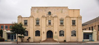
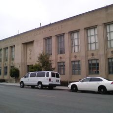
Monterey County Jail is a prison building in Salinas, California, built in 1930 and combining Art Deco, Gothic, and Classical design elements. The brick structure with sturdy, simple construction features small windows and reflects the functional style of county detention facilities from that era.

The building was constructed in 1930 and added to the National Register of Historic Places in 2004, recognized for its architecture and connection to Cesar Chavez and the labor movement. A court of appeal decision in 2004 also protected the structure from demolition, affirming its importance as a historic site.

The jail is deeply connected to Cesar Chavez and the farm workers' movement, as he was detained here in 1970. His imprisonment drew prominent supporters like Ethel Kennedy and Coretta Scott King, making the building a symbol of labor resistance in California.

The jail is located in downtown Salinas on W. Alisal Street, a busy thoroughfare with shops and other buildings nearby. The structure is easily accessible on foot and can be viewed from the outside to observe its historical architecture.

The building gained prominence through Cesar Chavez's detention here from December 4 to 24, 1970, when he refused to end a lettuce boycott. His case drew international attention to farm worker issues and transformed the location into a symbol of social change in America.

The community of curious travelers

AroundUs brings together thousands of curated places, local tips, and hidden gems, enriched daily by 60,000 contributors worldwide.

Start exploring
Location
GPS coordinates
36.67333,-121.65944
Latest update
February 9, 2026 08:21
Around this place
WeatherTech Raceway Laguna Seca
United States of America

WeatherTech Raceway Laguna Seca

12.9 km
Tehàma Golf Club
United States of America

Tehàma Golf Club

20.1 km
Fremont Peak
United States of America

Fremont Peak

16.7 km
National Steinbeck Center
United States of America

National Steinbeck Center

550 m
Fort Ord Dunes State Park
United States of America

Fort Ord Dunes State Park

14.7 km
Fremont Peak State Park
United States of America

Fremont Peak State Park

17 km
Marina State Beach
United States of America

Marina State Beach

13.7 km
Moss Landing State Beach
United States of America

Moss Landing State Beach

19.5 km
Salinas River State Beach
United States of America

Salinas River State Beach

17.3 km
Salinas River National Wildlife Refuge
United States of America

Salinas River National Wildlife Refuge

15 km
Marina State Beach
United States of America

Marina State Beach

13.7 km
Fremont Peak Observatory
United States of America

Fremont Peak Observatory

17.3 km
Rancho Las Palmas
United States of America

Rancho Las Palmas

5.9 km
Jose Eusebio Boronda Adobe
United States of America

Jose Eusebio Boronda Adobe

3.5 km
Monterey County Court House
United States of America

Monterey County Court House

59 m
Krough House
United States of America

Krough House

374 m
Monterey State Beach
United States of America

Monterey State Beach

19.6 km
Fort Ord Station Veterinary Hospital
United States of America

Fort Ord Station Veterinary Hospital

12.5 km
Sheriff William Joseph Nesbitt House
United States of America

Sheriff William Joseph Nesbitt House

414 m
Castroville Japanese Language School
United States of America

Castroville Japanese Language School

13 km
Giant artichoke
United States of America

Giant artichoke

13 km
Samuel M. Black House
United States of America

Samuel M. Black House

776 m
Monterey Zoo
United States of America

Monterey Zoo

9.3 km
Peter J. Bontadelli House
United States of America

Peter J. Bontadelli House

9.9 km
B. V. Sargent House
United States of America

B. V. Sargent House

340 m
Monterey Lanes
United States of America

Monterey Lanes

19.8 km
Jetty Beach
United States of America

Jetty Beach

19.1 km
Island Beach
United States of America

Island Beach

18.6 km
Show the full map
« Monterey County Jail - Gefängnis in den Vereinigten Staaten » is provided by Around Us (aroundus.com). Images and texts are derived from Wikimedia project under a Creative Commons license. You are allowed to copy, distribute, and modify copies of this page, under the conditions set by the license, as long as this note is clearly visible.

Discover hidden gems everywhere you go!

From secret cafés to breathtaking viewpoints, skip the crowded tourist spots and find places that match your style. Our app makes it easy with voice search, smart filtering, route optimization, and insider tips from travelers worldwide. Download now for the complete mobile experience.

Around Us App Screenshot

A unique approach to discovering new places

Le Figaro

All the places worth exploring

France Info

A tailor-made excursion in just a few clicks

20 Minutes

Around Us
Travel Guide & Maps
Download

Send to your phone

QR Code
1

Open the camera app on your mobile.

2

Point at the QR code with your camera. A notification will appear.

3

Tap the notification to open the link.