Fort Ord Dunes State Park

Log in to your account

AroundUs is a community-driven map of interesting places, built by curious explorers like you. It grows with every review, story, and photo you share.
Connect to save your favorite spots, contribute locations, and create personalized routes.
Continue with Google
Continue with Apple
Continue with X
Continue with Facebook
Continue with email
By continuing, you accept our Terms and Conditions and our Privacy Policy
Create an account
Add to collection
Map
Suggest a change
Share

Fort Ord Dunes State Park, State park along Pacific coastline in Monterey County, United States.

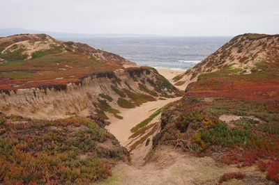
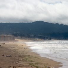
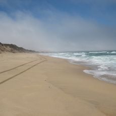
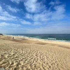
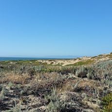
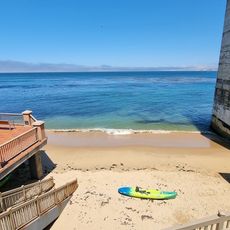
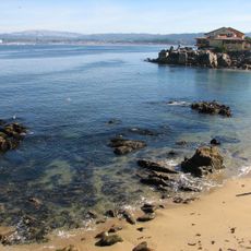
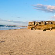
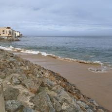
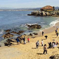
Fort Ord Dunes State Park is a protected coastal area spanning roughly 1,000 acres with about 6 miles (10 km) of beach along Monterey Bay. The landscape features rolling dunes, coastal bluffs, and a network of trails that wind through sand formations and natural vegetation.

The land served as a United States Army training base from the 1940s until 2000, when military operations ended. In 2009, it officially became a public park through a program that converted former military properties into accessible outdoor spaces.

The site now functions as a place where people gather to enjoy nature while learning about its military past and ecological importance. Interpretive signs throughout the grounds help visitors understand how the landscape has been repurposed for recreation and conservation.

The park is open during daylight hours and welcoming to walkers, cyclists, and hikers of various abilities. Wearing sturdy shoes is recommended since sandy terrain can be uneven, and staying on marked paths helps protect both you and the land.

The dunes serve as nesting habitat for rare bird species and other wildlife, which is why visitors must stay on trails to protect these sensitive ecosystems. This careful management allows animals to thrive in this coastal setting.

Location: Monterey County

Inception: 2009

Operator: California Department of Parks and Recreation

Website: https://parks.ca.gov/?page_id=580

GPS coordinates: 36.65440,-121.82200

Latest update: December 6, 2025 17:41

Photos
Alternative destinations in California

California offers more than its well-traveled routes. Across the state, locations exist that few visitors reach, even though they show landscapes and histories found nowhere else. This collection includes natural areas, abandoned structures, and stretches of coast that lie beyond the usual travel...

Around this place
Monterey Bay Aquarium
United States of America

Monterey Bay Aquarium

8.2 km
Monterey State Historic Park
United States of America

Monterey State Historic Park

8.6 km
Cathedral of San Carlos Borromeo
United States of America

Cathedral of San Carlos Borromeo

8.9 km
Pacific Biological Laboratories
United States of America

Pacific Biological Laboratories

8.1 km
Monterey State Beach
United States of America

Monterey State Beach

8.1 km
Marina State Beach
United States of America

Marina State Beach

3.4 km
Fisherman's Wharf, Monterey, California
United States of America

Fisherman's Wharf, Monterey, California

8.5 km
Old Customhouse
United States of America

Old Customhouse

8.6 km
California's First Theatre
United States of America

California's First Theatre

8.7 km
Edward F. Ricketts State Marine Conservation Area
United States of America

Edward F. Ricketts State Marine Conservation Area

8 km
Hyatt Regency Monterey Hotel and Spa on Del Monte Golf Course
United States of America

Hyatt Regency Monterey Hotel and Spa on Del Monte Golf Course

8.5 km
Marina State Beach
United States of America

Marina State Beach

5.1 km
Monterey Maritime and History Museum
United States of America

Monterey Maritime and History Museum

8.6 km
Wharf Theater
United States of America

Wharf Theater

8.3 km
St. John's Chapel
United States of America

St. John's Chapel

8.2 km
Monterey State Beach
United States of America

Monterey State Beach

6.4 km
Fort Ord Station Veterinary Hospital
United States of America

Fort Ord Station Veterinary Hospital

2.2 km
Trimmer Hill
United States of America

Trimmer Hill

8.9 km
Lou Ellen Parmelee House
United States of America

Lou Ellen Parmelee House

8.8 km
Peter J. Bontadelli House
United States of America

Peter J. Bontadelli House

5.3 km
Josiah Merritt Adobe
United States of America

Josiah Merritt Adobe

8.9 km
Monterey Bay Aquarium
United States of America

Monterey Bay Aquarium

8.2 km
Cannery Row Monument
United States of America

Cannery Row Monument

8.2 km
Aeneas Beach
United States of America

Aeneas Beach

8.2 km
Macabee Beach
United States of America

Macabee Beach

8.1 km
Del Monte Beach
United States of America

Del Monte Beach

7.2 km
San Carlos Beach
United States of America

San Carlos Beach

8.2 km
McAbee Beach
United States of America

McAbee Beach

8.1 km
Show the full map
Reviews

Visited this place? Tap the stars to rate it and share your experience / photos with the community! Try now! You can cancel it anytime.

« Fort Ord Dunes State Park - State park along Pacific coastline in Monterey County, United States » is provided by Around Us (aroundus.com). Images and texts are derived from Wikimedia project under a Creative Commons license. You are allowed to copy, distribute, and modify copies of this page, under the conditions set by the license, as long as this note is clearly visible.

Discover hidden gems everywhere you go!

From secret cafés to breathtaking viewpoints, skip the crowded tourist spots and find places that match your style. Our app makes it easy with voice search, smart filtering, route optimization, and insider tips from travelers worldwide. Download now for the complete mobile experience.

Around Us App Screenshot

A unique approach to discovering new places

Le Figaro

All the places worth exploring

France Info

A tailor-made excursion in just a few clicks

20 Minutes