See the monuments around you in AROpen chests in the app
Around Us is built for your phone — point your camera at the streets and discover the monuments and places around you in augmented reality.Around Us is built for your phone — chests unlock when you walk, explore and capture nearby places.
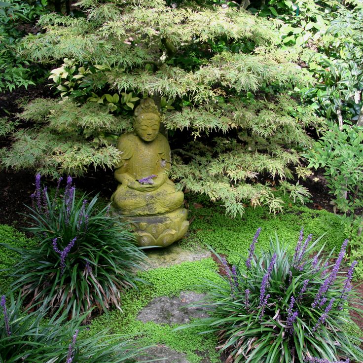
California offers more than its well-traveled routes. Across the state, locations exist that few visitors reach, even though they show landscapes and histories found nowhere else. This collection includes natural areas, abandoned structures, and stretches of coast that lie beyond the usual travel circuits.
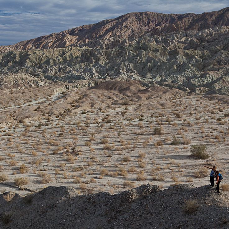
Destinations range from Fern Canyon with its moss-covered walls in Humboldt County to the volcanic cone of Amboy Crater in the Mojave Desert and the ruins of Sutro Baths in San Francisco. Beaches such as Pfeiffer Beach and El Matador Beach offer sand and rocky coves. Bodie State Historic Park preserves a ghost town from the 1800s, while the Salton Sea presents a vast salt lake in the middle of the desert. Other places include sea caves in Dana Point, hot springs in Death Valley, and metal sculptures in the Anza-Borrego Desert.
California offers more than its well-traveled routes. Across the state, locations exist that few visitors reach, even though they show landscapes and histories found nowhere else. This collection includes natural areas, abandoned structures, and stretches of coast that lie beyond the usual travel circuits.
Destinations range from Fern Canyon with its moss-covered walls in Humboldt County to the volcanic cone of Amboy Crater in the Mojave Desert and the ruins of Sutro Baths in San Francisco. Beaches such as Pfeiffer Beach and El Matador Beach offer sand and rocky coves. Bodie State Historic Park preserves a ghost town from the 1800s, while the Salton Sea presents a vast salt lake in the middle of the desert. Other places include sea caves in Dana Point, hot springs in Death Valley, and metal sculptures in the Anza-Borrego Desert.
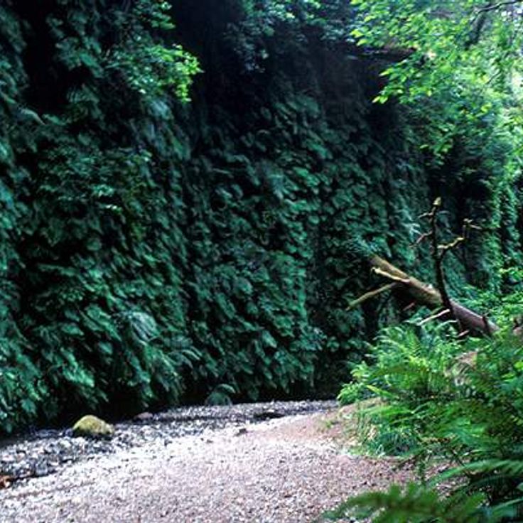
This canyon in Prairie Creek Redwoods State Park rises to about 30 feet (9 meters). The damp walls carry various fern species that form thick green carpets. The path follows a creek through the narrow gorge. Water flows over the ground and keeps the vegetation fresh. Visitors walk on wooden footbridges or directly through the shallow stream. The air feels cool. Light falls through the opening above. This place belongs to the less traveled natural destinations in California, where plants cover the rock walls and create a quiet environment.
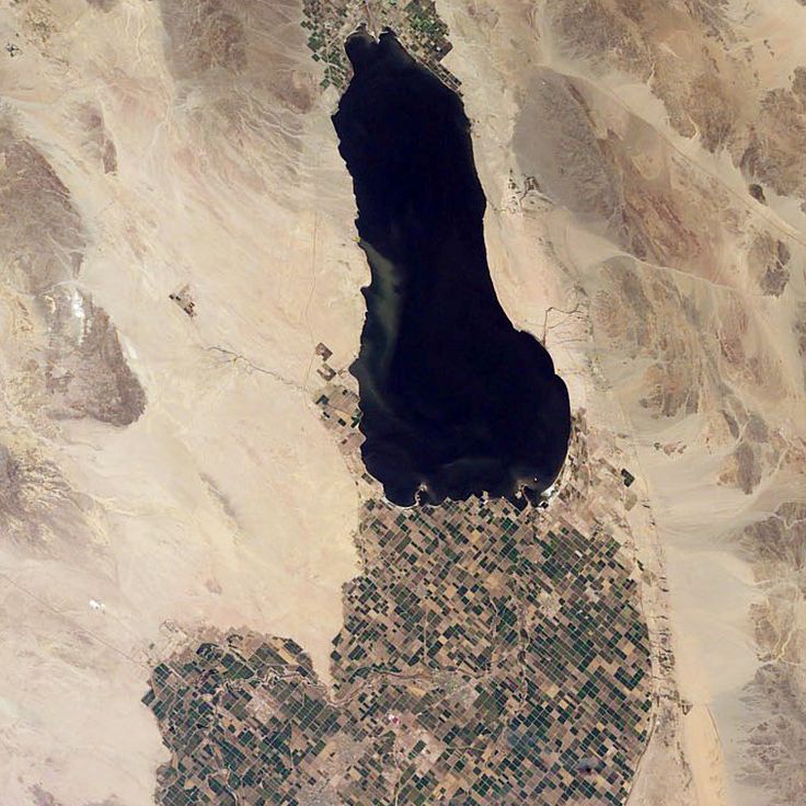
This salt lake sits on the San Andreas Fault in the Colorado Desert. The basin formed in 1905 when the Colorado River broke through a canal system and flowed into a natural depression for two years. The water holds more salt than the ocean, with minerals concentrated over decades. Shorelines are covered in barnacle shells, and the shallow water reflects the desert mountains. The lake attracts migratory birds that stop in this dry region. Geothermal springs emerge from the ground along the southern shore. Coastal towns were once resorts, now abandoned buildings stand at the water edge. Salinity varies with evaporation and inflow from agricultural canals.
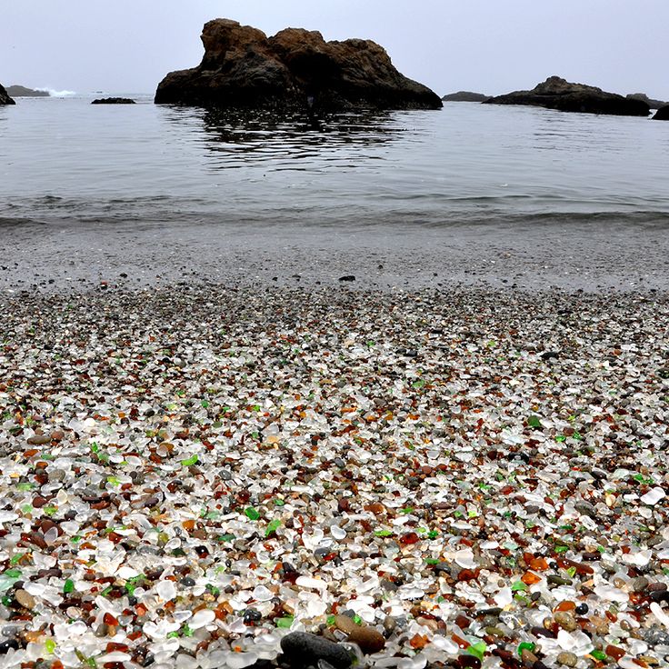
This beach is made of polished glass pieces from a former garbage dump. Between 1906 and 1967, residents threw their waste into the ocean, including bottles and glass. The waves polished the material over decades into smooth, colorful pebbles. The area is now part of MacKerricher State Park and shows how nature transforms human leftovers. Visitors can look at the pebbles but should not take them away.
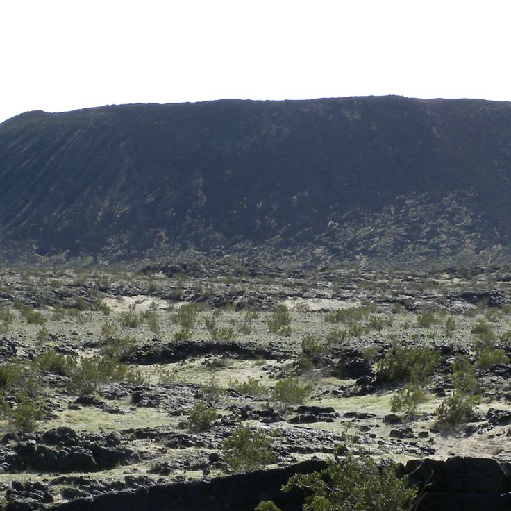
This volcanic crater rises 250 feet above the flat Mojave Desert floor. Amboy Crater formed around 79,000 years ago when magma pushed through cracks in the desert ground and built a cone of black lava rock. The crater is among the younger geological formations in this region and offers wide views across the desert landscape when the sky is clear. A hiking trail leads through lava fields up to the crater rim. The surroundings still show clear traces of volcanic activity: black rock fragments, cinder cones and hardened lava flows shape the view.
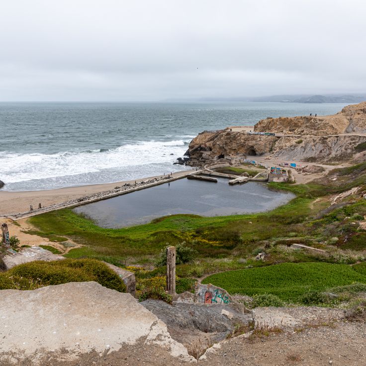
These abandoned baths sit on cliffs above the Pacific at the edge of San Francisco. Sutro Baths were built in the late 19th century and drew thousands of visitors who swam in enormous saltwater pools. Today only foundations and tunnel remnants remain. Wind sweeps through the ruins, and waves crash against the rocks below. You walk among the remains of the old structure and see parts of the foundations. The coast feels raw and open, with views of the ocean.
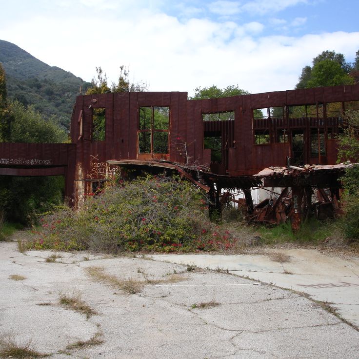
This abandoned settlement from the 1930s sits hidden in Rustic Canyon. The trail leads through forest to concrete walls covered in graffiti. Old staircases climb between trees, foundations of former buildings are overgrown with plants. The compound was planned as a self-sufficient complex but never completed. Today visitors hike through the ruins and explore the different levels. Eucalyptus trees and brush grow between the structures.
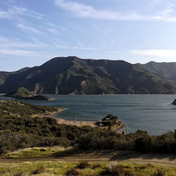
Pyramid Lake is a reservoir in Los Angeles County, built as part of the California State Water Project. The most noticeable feature of this body of water is a triangular rock formation on the shore, which gives the lake its name. The area offers access to trails and viewpoints where visitors can look out over the water and the surrounding hills. The lake serves both water supply and recreation; people come here to fish, boat, or spend a day outdoors. The landscape is marked by dry slopes and open sky, typical of this part of California away from the coast.
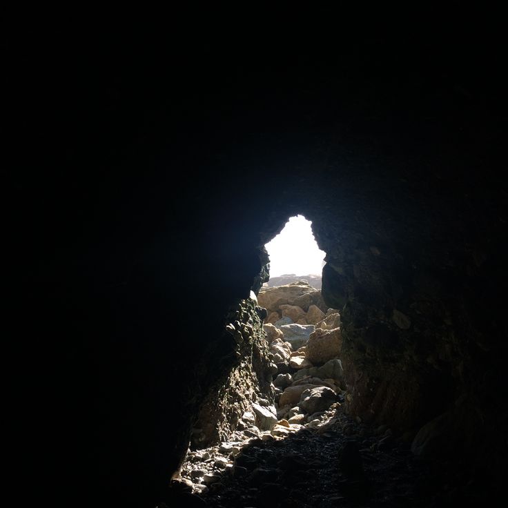
This volcanic area in northern California formed from lava flows that poured from the Medicine Lake Volcano thousands of years ago. The landscape shows frozen lava fields, cinder cones, and more than 800 caves that developed when the outer crust of lava cooled while molten rock continued flowing underneath, leaving hollow tubes behind. Visitors can walk through several of these lava tubes with flashlights. The walls sometimes shine black like glass. Some caves feel cool and damp, others dry with sharp-edged stones. On the surface, pines and junipers grow between the dark rock formations. This monument lies away from main routes and sees few travelers.
This park in the Mojave Desert gathers forty religious sculptures made of concrete, built during the 1950s. The figures stand scattered across sandy ground between cacti and boulders. A sculptor created them over several years, inspired by biblical scenes. Visitors walk among the white statues, which stand out against the blue sky and cast their shadows across the desert floor throughout the day.
Nitt Witt Ridge is a house built by Arthur Harold Beal over five decades using found materials such as beer cans, drain pipes and televisions. The property rises in terraces up a hillside, with each level constructed from repurposed objects. Beal began the work in the 1930s, adding layers of debris, bottles and industrial remnants over time. The construction demonstrates one man's response to waste across many years.
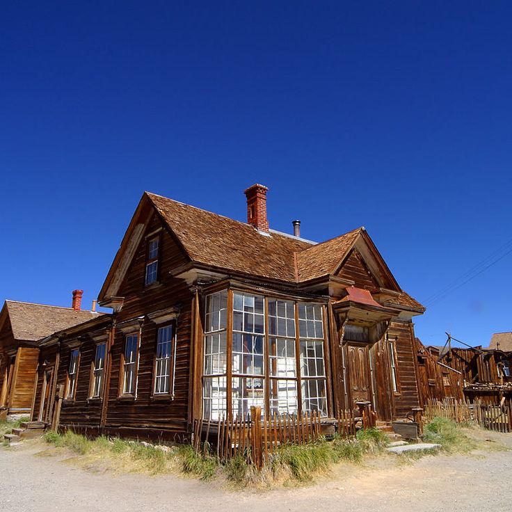
This location is part of a route through lesser-traveled destinations in California. Bodie State Historic Park preserves a gold rush town from the 1880s. The 170 buildings still contain furniture, goods and tools from that period. Streets and houses show daily life as miners and merchants knew it. Wooden structures, a church, saloons and shops form the townscape. Summers are hot and dry, winters bring snow to the empty rooftops.
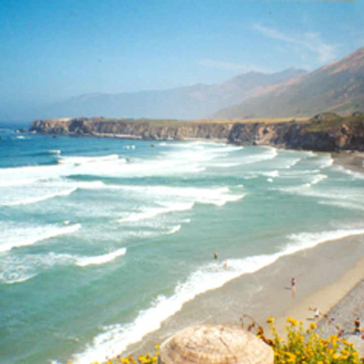
This beach at Big Sur shows purple-tinted sand colored by manganese. A rock formation with a natural arch rises about 80 feet. Waves shape the shore, patches of dark purple mix with lighter sand. The ocean flows through the opening in the stone, at sunset light passes through the gap. Access is by a narrow road, parking is limited. Strong currents make swimming dangerous. Driftwood gathers at the upper edge of the beach, birds search the tide zone for food.
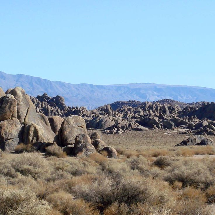
This granite hill country lies between Mount Whitney and the Mojave Desert. Rounded boulders and smooth formations of reddish stone shape the terrain. Since 1920, the site has served as a filming location for over 400 movies, including many westerns. Trails wind between the rocks, where light and shadow shift throughout the day. The Sierra Nevada forms the backdrop to the west.
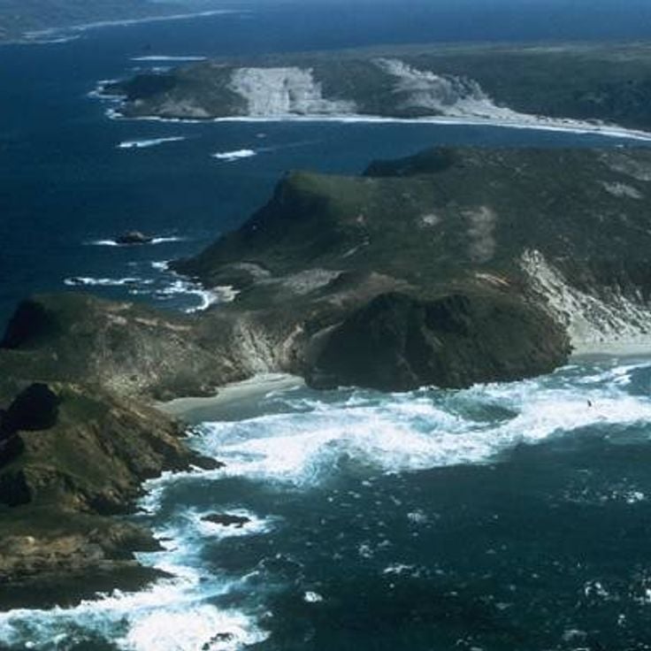
This national park consists of five islands off the coast: Anacapa, Santa Cruz, Santa Rosa, San Miguel, and Santa Barbara. The islands preserve habitats for 145 animal species, including seals, seabirds, and island foxes. Visitors reach the islands by boat or plane and find hiking trails, kayaking routes, and diving sites. The waters around the islands show kelp forests and sea caves. The park lies beyond main routes and offers access to coastal landscapes that differ from mainland California.
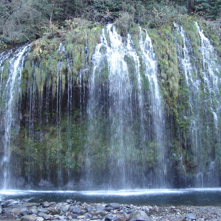
Mossbrae Falls is a waterfall along the Sacramento River, about 50 feet (15 meters) high and 175 feet (53 meters) wide. The water flows through a wall of moss and ferns that cover the slope. This spot lies beyond the usual California routes and fits into a collection that includes volcanic craters, caves, nineteenth-century bath ruins and beaches. The waterfall is reached by a path along the railroad tracks, where the green vegetation contrasts with the rock and the river passes by. The moss stays green year-round, fed by springs that seep through the stone.
This beach sits along the northern stretch of Malibu coast and belongs to the California destinations away from crowded routes. El Matador Beach shows large rock formations rising from the sand and natural caves that open at low tide. A wooden stairway descends from the clifftop parking area to the shore. The water stays cold year round and waves break hard against the rocks. People come here to walk among the formations and photograph the light passing through the stone arches, especially at sunset.
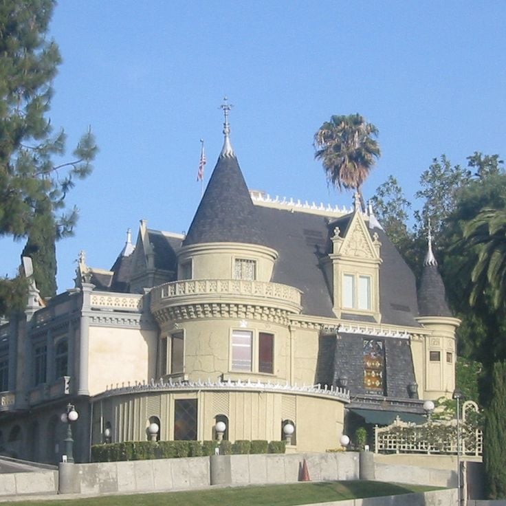
This Victorian mansion in Hollywood serves as a private club for magicians and their guests. The Magic Castle was founded in 1963 and operates as a social gathering place for professional illusionists from around the world. The interior rooms are designed like a 19th-century theater, with dark wood paneling, red velvet curtains, and low lighting. Several small stages are scattered across the floors, where close-up magic and illusions are performed in the evenings. Access requires an invitation or accompaniment by a member. Visitors wear formal attire and experience shows in rotating parlors while walking through winding hallways and hidden doors.
This art pavilion sits on a hilltop in Pomona and was built in the late 1980s from plans by James Turrell. The structure features an opening in the ceiling through which visitors observe the sky. Light emitting diodes alter the perception of colors during sunrise and sunset. The installation belongs to the category of Skyspaces and invites quiet observation. The building is located on the campus of Pomona College and is accessible at specific times.
This natural reserve protects granite cliffs, coves and forests along the California coast. Sea lions rest on the rocks, sea otters swim in the coves, and gray whales pass within view. Walking paths lead through cypress groves to lookout points over the ocean. The reserve shows the raw coastal landscape of California away from usual tourist routes, where visitors can watch marine animals in their natural habitat.
This botanical garden covers around 37 acres and displays plant collections assembled by Ganna Walska. Visitors find cacti from different climate zones, bromeliads in shaded areas, and a Japanese garden with ponds and stone lanterns. Paths lead through thematic sections where succulents, palms, and tropical plants grow. The estate was once a private residence and now opens its gardens for guided tours that move through the different plant zones.
The Sobrante Ridge Regional Preserve protects about 277 acres of hillside where the largest group of pallid manzanita shrubs left in the East Bay regional parks still grows. These rare plants spread across the slopes among grasslands and oak woodlands. Trails lead through open country with views toward San Pablo Bay and the surrounding hills. The preserve lies away from main routes and shows a piece of California nature that has nearly disappeared elsewhere in the region.
This former neighborhood collapsed in 1929 when the hillside gave way. Concrete foundations and street fragments now scatter across the cliff edge near Point Fermin. Walls rise from the ground, stairs lead nowhere, and the Pacific surf reshapes the rubble. Visitors walk among the ruins and see nature reclaiming the structures. The collapse shows how the coast continues to shift.
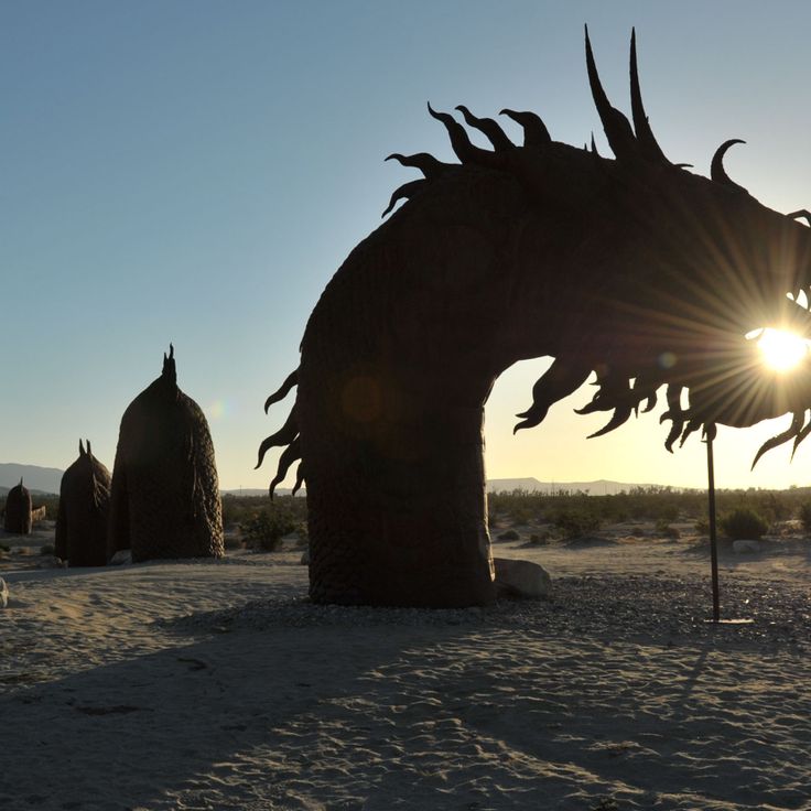
These metal sculptures by Ricardo Breceda stand freely in the desert landscape of Anza-Borrego Desert State Park. The 130 figures show prehistoric animals, historical characters, and fantasy creatures. The sculptures spread across different areas of the park and remain visible from the road. Visitors can walk among the figures and view them up close. The metalwork reflects the desert sunlight and forms a contrast against the sparse surroundings of sand and low brush.
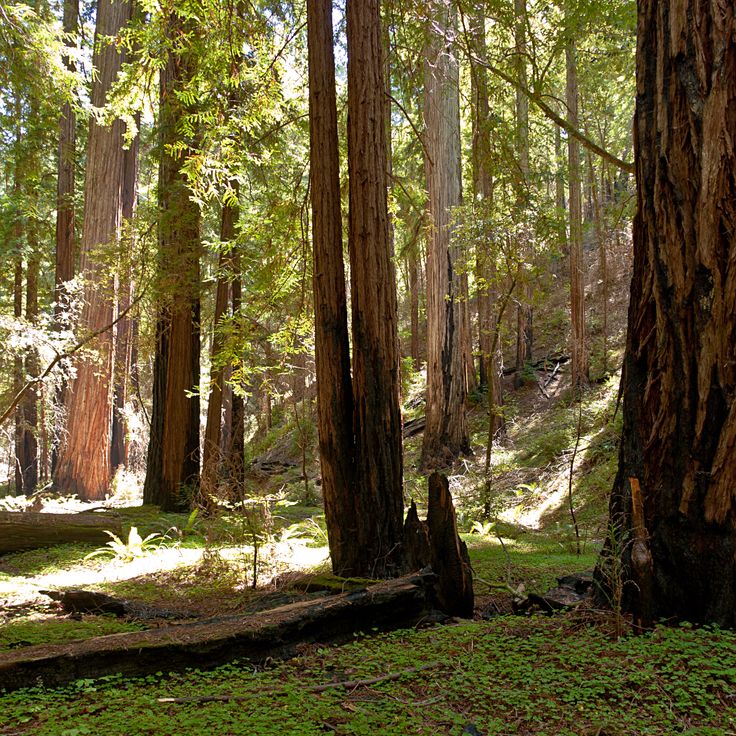
This reserve lies in northern California and protects old coastal redwoods that rank among the tallest trees on Earth. A roughly 2-mile loop trail winds through the grove, where some trees rise more than 350 feet. The path follows a creek and passes trunks that have stood for centuries. The reserve sees fewer visitors than other redwood sites, offering quiet among the close trunks and canopy overhead. Ferns and moss grow on the forest floor, and the air is cool and damp. Montgomery Woods fits into a California route that moves away from main highways and brings natural places to the foreground.
These canyons reveal rock walls with red, orange, and yellow layers formed over millions of years through tectonic shifts and erosion. The gorges sit in a remote desert area of the Mecca Hills, where winding paths lead between tall stone walls. Hikers move through narrow passages where the rock forms spiral and wave-like shapes.
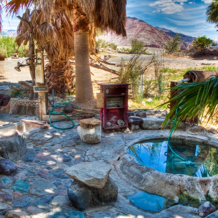
These hot springs emerge from heated groundwater that surfaces in a side valley of the Death Valley region. The water reaches around 40 to 45 degrees Celsius and fills several pools, some built by visitors over time. Palm trees and low plants mark the location among rocky and sandy plains. People reach the springs via unpaved roads that require vehicles suited for rough terrain. Saline Valley Hot Springs sit far from towns and supply points. Visitors come to soak in warm water and experience the silence of the desert landscape.
These sea caves sit at the edge of the Pacific, carved by wind and waves working on the rock over time. At low tide, pools form at their base where you can find sea anemones, crabs and small fish moving in shallow water. The ocean flows through narrow gaps and continues to shape the formations. On clear days you can look into the caves from shore and watch the tide levels change. Access depends on tides and weather conditions. The caves lie in a coastal area with sandy beaches and rocky sections nearby.
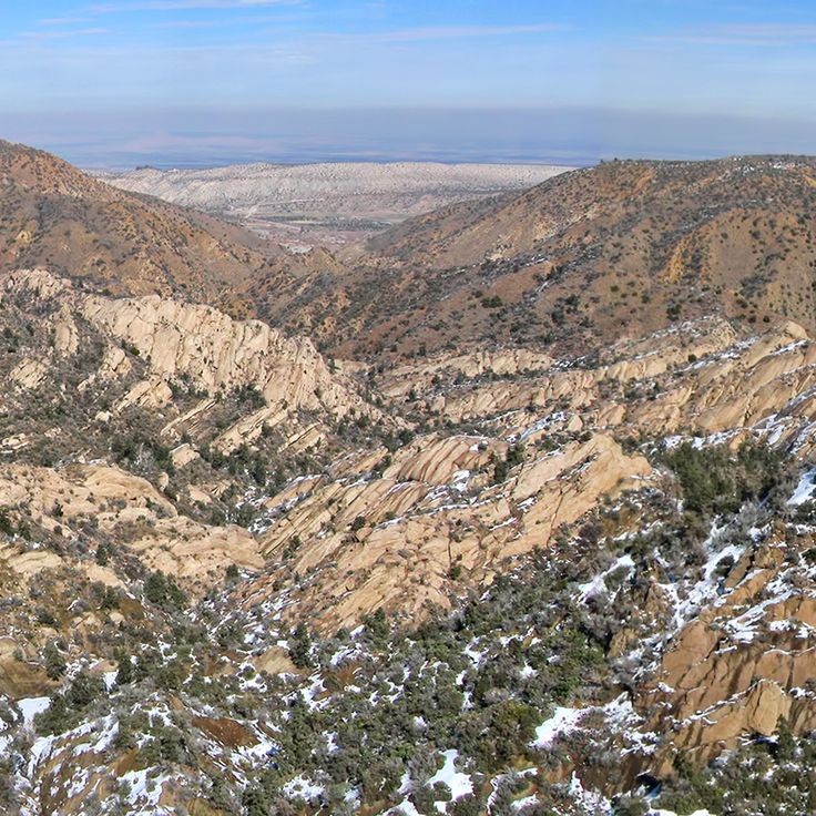
This sandstone formation in Angeles National Forest formed through tectonic forces along the San Andreas Fault. The rock walls stand at sharp angles to each other, where two plates met and pushed the stone upward. Hiking trails run through the broken canyon between slanted rock layers. The area shows how geological movement shapes land over long periods. Visitors see bands of reddish-brown rock pointing steeply upward and deep cuts in the stone. In spring, wildflowers grow between the rocks, and lizards use the warm surfaces to sun themselves.
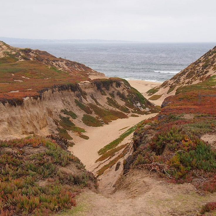
This park along Monterey Bay offers around 4 miles (6 km) of coast with sand beaches and tall dunes. The area once belonged to a military base and is now a quiet place for walks on the sand hills, where you see the open ocean and watch seabirds. The dunes form a gentle rolling line along the shore.
This reserve protects old oak trees that grow on sand dunes along the coast. The gnarled trunks rise from soft sand and form a shaded woodland crossed by walking paths. You walk beneath low branches that spread in all directions while your feet sink slightly into the ground. The bark is thick and cracked, revealing centuries of growth in this unusual setting. Birds nest in the canopy and light filters through the leaves onto the sandy floor below. The combination of oaks and dunes creates a rare landscape found only in a few coastal areas of California. Trails loop through different sections, some more open, others dense with vegetation and fallen wood.
This beach stretches for about a kilometer along the California coast south of Carmel. Geological conditions bring jade to the surface, and collectors walk the sand looking for green stones. Waves roll in steadily, so surfers visit the cove regularly. Rocks line the northern end, while sandy sections extend to the south. Fog often moves across the water in the morning, and wind shapes patterns in the sand. The area belongs to the less visited beaches of Big Sur and keeps a quiet character.
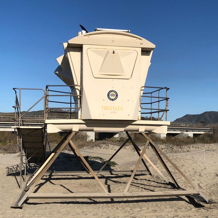
This surf beach lies in San Diego County and sits at the end of a roughly 1.2-mile (2-kilometer) trail. An old wooden railroad bridge crosses above the shoreline and marks the arrival point. Surfers come here for waves that break steadily across the sandbars. The beach offers sand to rest on between rides, while the weathered timbers of the historic bridge stand overhead.
This canyon in Prairie Creek Redwoods State Park rises to about 30 feet (9 meters). The damp walls carry various fern species that form thick green carpets. The path follows a creek through the narrow gorge. Water flows over the ground and keeps the vegetation fresh. Visitors walk on wooden footbridges or directly through the shallow stream. The air feels cool. Light falls through the opening above. This place belongs to the less traveled natural destinations in California, where plants cover the rock walls and create a quiet environment.
This salt lake sits on the San Andreas Fault in the Colorado Desert. The basin formed in 1905 when the Colorado River broke through a canal system and flowed into a natural depression for two years. The water holds more salt than the ocean, with minerals concentrated over decades. Shorelines are covered in barnacle shells, and the shallow water reflects the desert mountains. The lake attracts migratory birds that stop in this dry region. Geothermal springs emerge from the ground along the southern shore. Coastal towns were once resorts, now abandoned buildings stand at the water edge. Salinity varies with evaporation and inflow from agricultural canals.
This beach is made of polished glass pieces from a former garbage dump. Between 1906 and 1967, residents threw their waste into the ocean, including bottles and glass. The waves polished the material over decades into smooth, colorful pebbles. The area is now part of MacKerricher State Park and shows how nature transforms human leftovers. Visitors can look at the pebbles but should not take them away.
This volcanic crater rises 250 feet above the flat Mojave Desert floor. Amboy Crater formed around 79,000 years ago when magma pushed through cracks in the desert ground and built a cone of black lava rock. The crater is among the younger geological formations in this region and offers wide views across the desert landscape when the sky is clear. A hiking trail leads through lava fields up to the crater rim. The surroundings still show clear traces of volcanic activity: black rock fragments, cinder cones and hardened lava flows shape the view.
These abandoned baths sit on cliffs above the Pacific at the edge of San Francisco. Sutro Baths were built in the late 19th century and drew thousands of visitors who swam in enormous saltwater pools. Today only foundations and tunnel remnants remain. Wind sweeps through the ruins, and waves crash against the rocks below. You walk among the remains of the old structure and see parts of the foundations. The coast feels raw and open, with views of the ocean.
This abandoned settlement from the 1930s sits hidden in Rustic Canyon. The trail leads through forest to concrete walls covered in graffiti. Old staircases climb between trees, foundations of former buildings are overgrown with plants. The compound was planned as a self-sufficient complex but never completed. Today visitors hike through the ruins and explore the different levels. Eucalyptus trees and brush grow between the structures.
Pyramid Lake is a reservoir in Los Angeles County, built as part of the California State Water Project. The most noticeable feature of this body of water is a triangular rock formation on the shore, which gives the lake its name. The area offers access to trails and viewpoints where visitors can look out over the water and the surrounding hills. The lake serves both water supply and recreation; people come here to fish, boat, or spend a day outdoors. The landscape is marked by dry slopes and open sky, typical of this part of California away from the coast.
This volcanic area in northern California formed from lava flows that poured from the Medicine Lake Volcano thousands of years ago. The landscape shows frozen lava fields, cinder cones, and more than 800 caves that developed when the outer crust of lava cooled while molten rock continued flowing underneath, leaving hollow tubes behind. Visitors can walk through several of these lava tubes with flashlights. The walls sometimes shine black like glass. Some caves feel cool and damp, others dry with sharp-edged stones. On the surface, pines and junipers grow between the dark rock formations. This monument lies away from main routes and sees few travelers.
This park in the Mojave Desert gathers forty religious sculptures made of concrete, built during the 1950s. The figures stand scattered across sandy ground between cacti and boulders. A sculptor created them over several years, inspired by biblical scenes. Visitors walk among the white statues, which stand out against the blue sky and cast their shadows across the desert floor throughout the day.
Nitt Witt Ridge is a house built by Arthur Harold Beal over five decades using found materials such as beer cans, drain pipes and televisions. The property rises in terraces up a hillside, with each level constructed from repurposed objects. Beal began the work in the 1930s, adding layers of debris, bottles and industrial remnants over time. The construction demonstrates one man's response to waste across many years.
This location is part of a route through lesser-traveled destinations in California. Bodie State Historic Park preserves a gold rush town from the 1880s. The 170 buildings still contain furniture, goods and tools from that period. Streets and houses show daily life as miners and merchants knew it. Wooden structures, a church, saloons and shops form the townscape. Summers are hot and dry, winters bring snow to the empty rooftops.
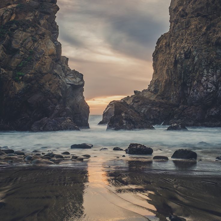
This beach at Big Sur shows purple-tinted sand colored by manganese. A rock formation with a natural arch rises about 80 feet. Waves shape the shore, patches of dark purple mix with lighter sand. The ocean flows through the opening in the stone, at sunset light passes through the gap. Access is by a narrow road, parking is limited. Strong currents make swimming dangerous. Driftwood gathers at the upper edge of the beach, birds search the tide zone for food.
This granite hill country lies between Mount Whitney and the Mojave Desert. Rounded boulders and smooth formations of reddish stone shape the terrain. Since 1920, the site has served as a filming location for over 400 movies, including many westerns. Trails wind between the rocks, where light and shadow shift throughout the day. The Sierra Nevada forms the backdrop to the west.
This national park consists of five islands off the coast: Anacapa, Santa Cruz, Santa Rosa, San Miguel, and Santa Barbara. The islands preserve habitats for 145 animal species, including seals, seabirds, and island foxes. Visitors reach the islands by boat or plane and find hiking trails, kayaking routes, and diving sites. The waters around the islands show kelp forests and sea caves. The park lies beyond main routes and offers access to coastal landscapes that differ from mainland California.
Mossbrae Falls is a waterfall along the Sacramento River, about 50 feet (15 meters) high and 175 feet (53 meters) wide. The water flows through a wall of moss and ferns that cover the slope. This spot lies beyond the usual California routes and fits into a collection that includes volcanic craters, caves, nineteenth-century bath ruins and beaches. The waterfall is reached by a path along the railroad tracks, where the green vegetation contrasts with the rock and the river passes by. The moss stays green year-round, fed by springs that seep through the stone.
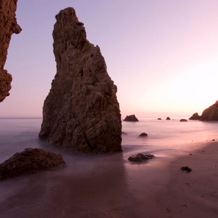
This beach sits along the northern stretch of Malibu coast and belongs to the California destinations away from crowded routes. El Matador Beach shows large rock formations rising from the sand and natural caves that open at low tide. A wooden stairway descends from the clifftop parking area to the shore. The water stays cold year round and waves break hard against the rocks. People come here to walk among the formations and photograph the light passing through the stone arches, especially at sunset.
This Victorian mansion in Hollywood serves as a private club for magicians and their guests. The Magic Castle was founded in 1963 and operates as a social gathering place for professional illusionists from around the world. The interior rooms are designed like a 19th-century theater, with dark wood paneling, red velvet curtains, and low lighting. Several small stages are scattered across the floors, where close-up magic and illusions are performed in the evenings. Access requires an invitation or accompaniment by a member. Visitors wear formal attire and experience shows in rotating parlors while walking through winding hallways and hidden doors.
This art pavilion sits on a hilltop in Pomona and was built in the late 1980s from plans by James Turrell. The structure features an opening in the ceiling through which visitors observe the sky. Light emitting diodes alter the perception of colors during sunrise and sunset. The installation belongs to the category of Skyspaces and invites quiet observation. The building is located on the campus of Pomona College and is accessible at specific times.
This natural reserve protects granite cliffs, coves and forests along the California coast. Sea lions rest on the rocks, sea otters swim in the coves, and gray whales pass within view. Walking paths lead through cypress groves to lookout points over the ocean. The reserve shows the raw coastal landscape of California away from usual tourist routes, where visitors can watch marine animals in their natural habitat.
This botanical garden covers around 37 acres and displays plant collections assembled by Ganna Walska. Visitors find cacti from different climate zones, bromeliads in shaded areas, and a Japanese garden with ponds and stone lanterns. Paths lead through thematic sections where succulents, palms, and tropical plants grow. The estate was once a private residence and now opens its gardens for guided tours that move through the different plant zones.
The Sobrante Ridge Regional Preserve protects about 277 acres of hillside where the largest group of pallid manzanita shrubs left in the East Bay regional parks still grows. These rare plants spread across the slopes among grasslands and oak woodlands. Trails lead through open country with views toward San Pablo Bay and the surrounding hills. The preserve lies away from main routes and shows a piece of California nature that has nearly disappeared elsewhere in the region.
This former neighborhood collapsed in 1929 when the hillside gave way. Concrete foundations and street fragments now scatter across the cliff edge near Point Fermin. Walls rise from the ground, stairs lead nowhere, and the Pacific surf reshapes the rubble. Visitors walk among the ruins and see nature reclaiming the structures. The collapse shows how the coast continues to shift.
These metal sculptures by Ricardo Breceda stand freely in the desert landscape of Anza-Borrego Desert State Park. The 130 figures show prehistoric animals, historical characters, and fantasy creatures. The sculptures spread across different areas of the park and remain visible from the road. Visitors can walk among the figures and view them up close. The metalwork reflects the desert sunlight and forms a contrast against the sparse surroundings of sand and low brush.
This reserve lies in northern California and protects old coastal redwoods that rank among the tallest trees on Earth. A roughly 2-mile loop trail winds through the grove, where some trees rise more than 350 feet. The path follows a creek and passes trunks that have stood for centuries. The reserve sees fewer visitors than other redwood sites, offering quiet among the close trunks and canopy overhead. Ferns and moss grow on the forest floor, and the air is cool and damp. Montgomery Woods fits into a California route that moves away from main highways and brings natural places to the foreground.
These canyons reveal rock walls with red, orange, and yellow layers formed over millions of years through tectonic shifts and erosion. The gorges sit in a remote desert area of the Mecca Hills, where winding paths lead between tall stone walls. Hikers move through narrow passages where the rock forms spiral and wave-like shapes.
These hot springs emerge from heated groundwater that surfaces in a side valley of the Death Valley region. The water reaches around 40 to 45 degrees Celsius and fills several pools, some built by visitors over time. Palm trees and low plants mark the location among rocky and sandy plains. People reach the springs via unpaved roads that require vehicles suited for rough terrain. Saline Valley Hot Springs sit far from towns and supply points. Visitors come to soak in warm water and experience the silence of the desert landscape.
These sea caves sit at the edge of the Pacific, carved by wind and waves working on the rock over time. At low tide, pools form at their base where you can find sea anemones, crabs and small fish moving in shallow water. The ocean flows through narrow gaps and continues to shape the formations. On clear days you can look into the caves from shore and watch the tide levels change. Access depends on tides and weather conditions. The caves lie in a coastal area with sandy beaches and rocky sections nearby.
This sandstone formation in Angeles National Forest formed through tectonic forces along the San Andreas Fault. The rock walls stand at sharp angles to each other, where two plates met and pushed the stone upward. Hiking trails run through the broken canyon between slanted rock layers. The area shows how geological movement shapes land over long periods. Visitors see bands of reddish-brown rock pointing steeply upward and deep cuts in the stone. In spring, wildflowers grow between the rocks, and lizards use the warm surfaces to sun themselves.
This park along Monterey Bay offers around 4 miles (6 km) of coast with sand beaches and tall dunes. The area once belonged to a military base and is now a quiet place for walks on the sand hills, where you see the open ocean and watch seabirds. The dunes form a gentle rolling line along the shore.
This reserve protects old oak trees that grow on sand dunes along the coast. The gnarled trunks rise from soft sand and form a shaded woodland crossed by walking paths. You walk beneath low branches that spread in all directions while your feet sink slightly into the ground. The bark is thick and cracked, revealing centuries of growth in this unusual setting. Birds nest in the canopy and light filters through the leaves onto the sandy floor below. The combination of oaks and dunes creates a rare landscape found only in a few coastal areas of California. Trails loop through different sections, some more open, others dense with vegetation and fallen wood.
This beach stretches for about a kilometer along the California coast south of Carmel. Geological conditions bring jade to the surface, and collectors walk the sand looking for green stones. Waves roll in steadily, so surfers visit the cove regularly. Rocks line the northern end, while sandy sections extend to the south. Fog often moves across the water in the morning, and wind shapes patterns in the sand. The area belongs to the less visited beaches of Big Sur and keeps a quiet character.
This surf beach lies in San Diego County and sits at the end of a roughly 1.2-mile (2-kilometer) trail. An old wooden railroad bridge crosses above the shoreline and marks the arrival point. Surfers come here for waves that break steadily across the sandbars. The beach offers sand to rest on between rides, while the weathered timbers of the historic bridge stand overhead.
This canyon in Prairie Creek Redwoods State Park rises to about 30 feet (9 meters). The damp walls carry various fern species that form thick green carpets. The path follows a creek through the narrow gorge. Water flows over the ground and keeps the vegetation fresh. Visitors walk on wooden footbridges or directly through the shallow stream. The air feels cool. Light falls through the opening above. This place belongs to the less traveled natural destinations in California, where plants cover the rock walls and create a quiet environment.
This salt lake sits on the San Andreas Fault in the Colorado Desert. The basin formed in 1905 when the Colorado River broke through a canal system and flowed into a natural depression for two years. The water holds more salt than the ocean, with minerals concentrated over decades. Shorelines are covered in barnacle shells, and the shallow water reflects the desert mountains. The lake attracts migratory birds that stop in this dry region. Geothermal springs emerge from the ground along the southern shore. Coastal towns were once resorts, now abandoned buildings stand at the water edge. Salinity varies with evaporation and inflow from agricultural canals.
This beach is made of polished glass pieces from a former garbage dump. Between 1906 and 1967, residents threw their waste into the ocean, including bottles and glass. The waves polished the material over decades into smooth, colorful pebbles. The area is now part of MacKerricher State Park and shows how nature transforms human leftovers. Visitors can look at the pebbles but should not take them away.
This volcanic crater rises 250 feet above the flat Mojave Desert floor. Amboy Crater formed around 79,000 years ago when magma pushed through cracks in the desert ground and built a cone of black lava rock. The crater is among the younger geological formations in this region and offers wide views across the desert landscape when the sky is clear. A hiking trail leads through lava fields up to the crater rim. The surroundings still show clear traces of volcanic activity: black rock fragments, cinder cones and hardened lava flows shape the view.
These abandoned baths sit on cliffs above the Pacific at the edge of San Francisco. Sutro Baths were built in the late 19th century and drew thousands of visitors who swam in enormous saltwater pools. Today only foundations and tunnel remnants remain. Wind sweeps through the ruins, and waves crash against the rocks below. You walk among the remains of the old structure and see parts of the foundations. The coast feels raw and open, with views of the ocean.
This abandoned settlement from the 1930s sits hidden in Rustic Canyon. The trail leads through forest to concrete walls covered in graffiti. Old staircases climb between trees, foundations of former buildings are overgrown with plants. The compound was planned as a self-sufficient complex but never completed. Today visitors hike through the ruins and explore the different levels. Eucalyptus trees and brush grow between the structures.
Pyramid Lake is a reservoir in Los Angeles County, built as part of the California State Water Project. The most noticeable feature of this body of water is a triangular rock formation on the shore, which gives the lake its name. The area offers access to trails and viewpoints where visitors can look out over the water and the surrounding hills. The lake serves both water supply and recreation; people come here to fish, boat, or spend a day outdoors. The landscape is marked by dry slopes and open sky, typical of this part of California away from the coast.
This volcanic area in northern California formed from lava flows that poured from the Medicine Lake Volcano thousands of years ago. The landscape shows frozen lava fields, cinder cones, and more than 800 caves that developed when the outer crust of lava cooled while molten rock continued flowing underneath, leaving hollow tubes behind. Visitors can walk through several of these lava tubes with flashlights. The walls sometimes shine black like glass. Some caves feel cool and damp, others dry with sharp-edged stones. On the surface, pines and junipers grow between the dark rock formations. This monument lies away from main routes and sees few travelers.
This park in the Mojave Desert gathers forty religious sculptures made of concrete, built during the 1950s. The figures stand scattered across sandy ground between cacti and boulders. A sculptor created them over several years, inspired by biblical scenes. Visitors walk among the white statues, which stand out against the blue sky and cast their shadows across the desert floor throughout the day.
Nitt Witt Ridge is a house built by Arthur Harold Beal over five decades using found materials such as beer cans, drain pipes and televisions. The property rises in terraces up a hillside, with each level constructed from repurposed objects. Beal began the work in the 1930s, adding layers of debris, bottles and industrial remnants over time. The construction demonstrates one man's response to waste across many years.
This location is part of a route through lesser-traveled destinations in California. Bodie State Historic Park preserves a gold rush town from the 1880s. The 170 buildings still contain furniture, goods and tools from that period. Streets and houses show daily life as miners and merchants knew it. Wooden structures, a church, saloons and shops form the townscape. Summers are hot and dry, winters bring snow to the empty rooftops.
This beach at Big Sur shows purple-tinted sand colored by manganese. A rock formation with a natural arch rises about 80 feet. Waves shape the shore, patches of dark purple mix with lighter sand. The ocean flows through the opening in the stone, at sunset light passes through the gap. Access is by a narrow road, parking is limited. Strong currents make swimming dangerous. Driftwood gathers at the upper edge of the beach, birds search the tide zone for food.
This granite hill country lies between Mount Whitney and the Mojave Desert. Rounded boulders and smooth formations of reddish stone shape the terrain. Since 1920, the site has served as a filming location for over 400 movies, including many westerns. Trails wind between the rocks, where light and shadow shift throughout the day. The Sierra Nevada forms the backdrop to the west.
This national park consists of five islands off the coast: Anacapa, Santa Cruz, Santa Rosa, San Miguel, and Santa Barbara. The islands preserve habitats for 145 animal species, including seals, seabirds, and island foxes. Visitors reach the islands by boat or plane and find hiking trails, kayaking routes, and diving sites. The waters around the islands show kelp forests and sea caves. The park lies beyond main routes and offers access to coastal landscapes that differ from mainland California.
Mossbrae Falls is a waterfall along the Sacramento River, about 50 feet (15 meters) high and 175 feet (53 meters) wide. The water flows through a wall of moss and ferns that cover the slope. This spot lies beyond the usual California routes and fits into a collection that includes volcanic craters, caves, nineteenth-century bath ruins and beaches. The waterfall is reached by a path along the railroad tracks, where the green vegetation contrasts with the rock and the river passes by. The moss stays green year-round, fed by springs that seep through the stone.
This beach sits along the northern stretch of Malibu coast and belongs to the California destinations away from crowded routes. El Matador Beach shows large rock formations rising from the sand and natural caves that open at low tide. A wooden stairway descends from the clifftop parking area to the shore. The water stays cold year round and waves break hard against the rocks. People come here to walk among the formations and photograph the light passing through the stone arches, especially at sunset.
This Victorian mansion in Hollywood serves as a private club for magicians and their guests. The Magic Castle was founded in 1963 and operates as a social gathering place for professional illusionists from around the world. The interior rooms are designed like a 19th-century theater, with dark wood paneling, red velvet curtains, and low lighting. Several small stages are scattered across the floors, where close-up magic and illusions are performed in the evenings. Access requires an invitation or accompaniment by a member. Visitors wear formal attire and experience shows in rotating parlors while walking through winding hallways and hidden doors.
This art pavilion sits on a hilltop in Pomona and was built in the late 1980s from plans by James Turrell. The structure features an opening in the ceiling through which visitors observe the sky. Light emitting diodes alter the perception of colors during sunrise and sunset. The installation belongs to the category of Skyspaces and invites quiet observation. The building is located on the campus of Pomona College and is accessible at specific times.
This natural reserve protects granite cliffs, coves and forests along the California coast. Sea lions rest on the rocks, sea otters swim in the coves, and gray whales pass within view. Walking paths lead through cypress groves to lookout points over the ocean. The reserve shows the raw coastal landscape of California away from usual tourist routes, where visitors can watch marine animals in their natural habitat.
This botanical garden covers around 37 acres and displays plant collections assembled by Ganna Walska. Visitors find cacti from different climate zones, bromeliads in shaded areas, and a Japanese garden with ponds and stone lanterns. Paths lead through thematic sections where succulents, palms, and tropical plants grow. The estate was once a private residence and now opens its gardens for guided tours that move through the different plant zones.
The Sobrante Ridge Regional Preserve protects about 277 acres of hillside where the largest group of pallid manzanita shrubs left in the East Bay regional parks still grows. These rare plants spread across the slopes among grasslands and oak woodlands. Trails lead through open country with views toward San Pablo Bay and the surrounding hills. The preserve lies away from main routes and shows a piece of California nature that has nearly disappeared elsewhere in the region.
This former neighborhood collapsed in 1929 when the hillside gave way. Concrete foundations and street fragments now scatter across the cliff edge near Point Fermin. Walls rise from the ground, stairs lead nowhere, and the Pacific surf reshapes the rubble. Visitors walk among the ruins and see nature reclaiming the structures. The collapse shows how the coast continues to shift.
These metal sculptures by Ricardo Breceda stand freely in the desert landscape of Anza-Borrego Desert State Park. The 130 figures show prehistoric animals, historical characters, and fantasy creatures. The sculptures spread across different areas of the park and remain visible from the road. Visitors can walk among the figures and view them up close. The metalwork reflects the desert sunlight and forms a contrast against the sparse surroundings of sand and low brush.
This reserve lies in northern California and protects old coastal redwoods that rank among the tallest trees on Earth. A roughly 2-mile loop trail winds through the grove, where some trees rise more than 350 feet. The path follows a creek and passes trunks that have stood for centuries. The reserve sees fewer visitors than other redwood sites, offering quiet among the close trunks and canopy overhead. Ferns and moss grow on the forest floor, and the air is cool and damp. Montgomery Woods fits into a California route that moves away from main highways and brings natural places to the foreground.
These canyons reveal rock walls with red, orange, and yellow layers formed over millions of years through tectonic shifts and erosion. The gorges sit in a remote desert area of the Mecca Hills, where winding paths lead between tall stone walls. Hikers move through narrow passages where the rock forms spiral and wave-like shapes.
These hot springs emerge from heated groundwater that surfaces in a side valley of the Death Valley region. The water reaches around 40 to 45 degrees Celsius and fills several pools, some built by visitors over time. Palm trees and low plants mark the location among rocky and sandy plains. People reach the springs via unpaved roads that require vehicles suited for rough terrain. Saline Valley Hot Springs sit far from towns and supply points. Visitors come to soak in warm water and experience the silence of the desert landscape.
These sea caves sit at the edge of the Pacific, carved by wind and waves working on the rock over time. At low tide, pools form at their base where you can find sea anemones, crabs and small fish moving in shallow water. The ocean flows through narrow gaps and continues to shape the formations. On clear days you can look into the caves from shore and watch the tide levels change. Access depends on tides and weather conditions. The caves lie in a coastal area with sandy beaches and rocky sections nearby.
This sandstone formation in Angeles National Forest formed through tectonic forces along the San Andreas Fault. The rock walls stand at sharp angles to each other, where two plates met and pushed the stone upward. Hiking trails run through the broken canyon between slanted rock layers. The area shows how geological movement shapes land over long periods. Visitors see bands of reddish-brown rock pointing steeply upward and deep cuts in the stone. In spring, wildflowers grow between the rocks, and lizards use the warm surfaces to sun themselves.
This park along Monterey Bay offers around 4 miles (6 km) of coast with sand beaches and tall dunes. The area once belonged to a military base and is now a quiet place for walks on the sand hills, where you see the open ocean and watch seabirds. The dunes form a gentle rolling line along the shore.
This reserve protects old oak trees that grow on sand dunes along the coast. The gnarled trunks rise from soft sand and form a shaded woodland crossed by walking paths. You walk beneath low branches that spread in all directions while your feet sink slightly into the ground. The bark is thick and cracked, revealing centuries of growth in this unusual setting. Birds nest in the canopy and light filters through the leaves onto the sandy floor below. The combination of oaks and dunes creates a rare landscape found only in a few coastal areas of California. Trails loop through different sections, some more open, others dense with vegetation and fallen wood.
This beach stretches for about a kilometer along the California coast south of Carmel. Geological conditions bring jade to the surface, and collectors walk the sand looking for green stones. Waves roll in steadily, so surfers visit the cove regularly. Rocks line the northern end, while sandy sections extend to the south. Fog often moves across the water in the morning, and wind shapes patterns in the sand. The area belongs to the less visited beaches of Big Sur and keeps a quiet character.
This surf beach lies in San Diego County and sits at the end of a roughly 1.2-mile (2-kilometer) trail. An old wooden railroad bridge crosses above the shoreline and marks the arrival point. Surfers come here for waves that break steadily across the sandbars. The beach offers sand to rest on between rides, while the weathered timbers of the historic bridge stand overhead.