Enable Location

We need your location to show you interesting places around you

Discover nearby places

Find interesting locations and hidden gems around you

Precise directions

Get accurate directions and distances to places

Your location is never shared with other users. It's only used when you tap the location button.

Sutter's Fort State Historic Park

Log in to your account

Start exploring — it's free

Trusted by 63,300 travelers worldwide

Continue with Google
Continue with Apple
or

We will send you a code to connect

By continuing, you accept our Terms and Conditions and our Privacy Policy

Check your inbox

We've sent a pincode in your inbox. Please enter the code below.

Sutter's Fort State Historic Park
Discussion Reviews 1 Photos 1 Collections
300+ Popularity

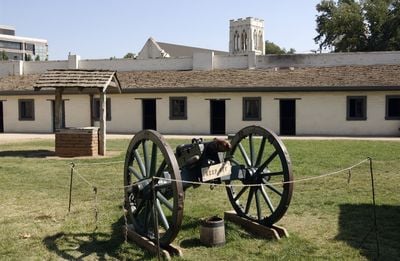
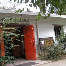
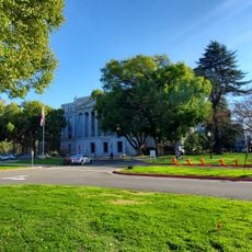
Sutter's Fort State Historic Park, park in Sacramento County, California, United States of America

Sutter's Fort State Historic Park is a reconstructed 19th-century trading post in Sacramento County that served as a crucial outpost during California's early settlement period. The fort displays the layout of living quarters, workshops, and storage buildings that were typical of an early American settlement.

The fort was founded in 1839 by John Sutter and quickly became a center of trade and settlement in Northern California. Its story is tied to the 1848 Gold Rush and California's rapid expansion.

The reconstructed fort is open to visitors and offers guided tours through its buildings and displays. It works best to visit during daytime when rangers are present to provide explanations and demonstrations of 19th-century life.

The fort served as an information center and supply depot for Gold Rush prospectors in 1848 before later being repurposed as a school and storage facility. Many of the structures visible today are reconstructions showing what the original looked like more than 150 years ago.

The community of curious travelers

AroundUs brings together thousands of curated places, local tips, and hidden gems, enriched daily by 60,000 contributors worldwide.

Start exploring
GPS coordinates
38.57222,-121.47083
Latest update
December 8, 2025 14:59
Sacramento: visit the California capital, its museums and historical landmarks

Sacramento offers a journey through Californian history, from the 1849 Gold Rush to today. The Old Sacramento district retains its 1850 brick buildings and Victorian facades, while the California State Capitol overlooks the city with its 16-hectare gardens. The California State Railroad Museum...

Around this place
Governor's Mansion State Historic Park
United States of America

Governor's Mansion State Historic Park

1.5 km
Sacramento Convention Center Complex
United States of America

Sacramento Convention Center Complex

1.7 km
California State Indian Museum
United States of America

California State Indian Museum

66 m
Julia Morgan House
United States of America

Julia Morgan House

1.7 km
Wells Fargo Pavilion
United States of America

Wells Fargo Pavilion

1.7 km
Libby, McNeil and Libby Cannery
United States of America

Libby, McNeil and Libby Cannery

967 m
United States of America

Boulevard Park, Sacramento, California

1.1 km
Old Tavern
United States of America

Old Tavern

225 m
California State Capitol Park
United States of America

California State Capitol Park

1.8 km
United States of America

New Helvetia Cemetery

605 m
Eastern Star Hall
United States of America

Eastern Star Hall

172 m
McKinley Park
United States of America

McKinley Park

937 m
Winters House
United States of America

Winters House

619 m
United States of America

Merrium Apartments

1.6 km
Cranston-Geary House
United States of America

Cranston-Geary House

946 m
Firehouse No. 3
United States of America

Firehouse No. 3

928 m
United States of America

Thomas Jefferson School

1.4 km
St. Paul's Church of Sacramento
United States of America

St. Paul's Church of Sacramento

1.6 km
United States of America

Capitol Park

1.8 km
United States of America

Sacramento Theatre Company

1.7 km
United States of America

The Sacramento Comedy Spot

936 m

Broadway at Music Circus

1.7 km
United States of America

Viewpoint | Photographic Art Center

862 m

B Sakata Garo

923 m
United States of America

Elliott Fouts Gallery

1.2 km
United States of America

Sacramento Community Center Theater

1.7 km
United States of America

Oaxaca

862 m
United States of America

Sculpture, Work of art

1.8 km
Show the full map
Reviews
Share your experience

No review yet

Discussions
Start a discussion...

No discussion yet

« Sutter's Fort State Historic Park - park in Sacramento County, California, United States of America » is provided by Around Us (aroundus.com). Images and texts are derived from Wikimedia project under a Creative Commons license. You are allowed to copy, distribute, and modify copies of this page, under the conditions set by the license, as long as this note is clearly visible.

Discover hidden gems everywhere you go!

From secret cafés to breathtaking viewpoints, skip the crowded tourist spots and find places that match your style. Our app makes it easy with voice search, smart filtering, route optimization, and insider tips from travelers worldwide. Download now for the complete mobile experience.

Around Us App Screenshot

A unique approach to discovering new places

Le Figaro

All the places worth exploring

France Info

A tailor-made excursion in just a few clicks

20 Minutes

Around Us
Travel Guide & Maps
Download

Send to your phone

QR Code
1

Open the camera app on your mobile.

2

Point at the QR code with your camera. A notification will appear.

3

Tap the notification to open the link.