Enable Location

We need your location to show you interesting places around you

Discover nearby places

Find interesting locations and hidden gems around you

Precise directions

Get accurate directions and distances to places

Your location is never shared with other users. It's only used when you tap the location button.

Libby, McNeil and Libby Cannery

Log in to your account

Start exploring — it's free

Trusted by 62,482 travelers worldwide

Continue with Google
Continue with Apple
or

We will send you a code to connect

By continuing, you accept our Terms and Conditions and our Privacy Policy

Check your inbox

We've sent a pincode in your inbox. Please enter the code below.

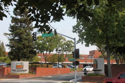
Libby, McNeil and Libby Cannery, a food cannery that was operated in Sacramento, California

The Libby, McNeil and Libby Cannery is a factory in Sacramento built in 1918 with nine red brick buildings that once processed fruits and vegetables. The structures stand closely together in a straightforward industrial design typical of early twentieth-century manufacturing.

The company was founded in 1868 and built this factory in 1918, making it the world's largest canning plant at that time. The operation ceased in 1982 after nearly seventy years of continuous production.

The cannery employed many local families and shaped the community around it for generations. The site remains a reminder of Sacramento's role in early American food production and the workers who made it possible.

The site sits easily accessible on Stockton Boulevard near Alhambra Street in Sacramento. The buildings now house offices and businesses, with limited public access depending on current occupants and programming.

The factory primarily employed women during its operation and provided them with rare benefits like worker housing and onsite childcare, a progressive practice for that era. These features were uncommon in the canning industry at the time.

The community of curious travelers

AroundUs brings together thousands of curated places, local tips, and hidden gems, enriched daily by 60,000 contributors worldwide.

Start exploring
Location
GPS coordinates
38.56440,-121.46600
Latest update
February 9, 2026 08:22
Around this place
California State Capitol
United States of America

California State Capitol

2.7 km
California Hall of Fame
United States of America

California Hall of Fame

2.8 km
California State Library
United States of America

California State Library

2.9 km
California State Capitol Museum
United States of America

California State Capitol Museum

2.8 km
Cathedral of the Blessed Sacrament
United States of America

Cathedral of the Blessed Sacrament

2.8 km
The California Museum
United States of America

The California Museum

2.8 km
Sacramento Convention Center Complex
United States of America

Sacramento Convention Center Complex

2.5 km
California State Indian Museum
United States of America

California State Indian Museum

1 km
Crest Theatre
United States of America

Crest Theatre

2.9 km
Julia Morgan House
United States of America

Julia Morgan House

771 m
Senator Hotel
United States of America

Senator Hotel

2.7 km
Wells Fargo Pavilion
United States of America

Wells Fargo Pavilion

2.6 km
Sacramento Masonic Temple
United States of America

Sacramento Masonic Temple

2.9 km
Old Tavern
United States of America

Old Tavern

759 m
California State Capitol Park
United States of America

California State Capitol Park

2.5 km
Esquire Tower
United States of America

Esquire Tower

2.7 km
IHOP
United States of America

IHOP

524 m
Cal/EPA Building
United States of America

Cal/EPA Building

3 km
Eastern Star Hall
United States of America

Eastern Star Hall

1.1 km
McKinley Park
United States of America

McKinley Park

1.3 km
Winters House
United States of America

Winters House

1.6 km
Statue of Thomas Starr King
United States of America

Statue of Thomas Starr King

2.6 km
Blue Anchor Building
United States of America

Blue Anchor Building

2.8 km
Sacramento Memorial Auditorium
United States of America

Sacramento Memorial Auditorium

2.4 km
Theodore Judah School
United States of America

Theodore Judah School

1.9 km
J. C. Carly House
United States of America

J. C. Carly House

1.9 km
Cranston-Geary House
United States of America

Cranston-Geary House

1.9 km
St. Paul's Church of Sacramento
United States of America

St. Paul's Church of Sacramento

2.4 km
Show the full map
« Libby, McNeil and Libby Cannery - a food cannery that was operated in Sacramento, California » is provided by Around Us (aroundus.com). Images and texts are derived from Wikimedia project under a Creative Commons license. You are allowed to copy, distribute, and modify copies of this page, under the conditions set by the license, as long as this note is clearly visible.

Discover hidden gems everywhere you go!

From secret cafés to breathtaking viewpoints, skip the crowded tourist spots and find places that match your style. Our app makes it easy with voice search, smart filtering, route optimization, and insider tips from travelers worldwide. Download now for the complete mobile experience.

Around Us App Screenshot

A unique approach to discovering new places

Le Figaro

All the places worth exploring

France Info

A tailor-made excursion in just a few clicks

20 Minutes

Around Us
Travel Guide & Maps
Download

Send to your phone

QR Code
1

Open the camera app on your mobile.

2

Point at the QR code with your camera. A notification will appear.

3

Tap the notification to open the link.