Enable Location

We need your location to show you interesting places around you

Discover nearby places

Find interesting locations and hidden gems around you

Precise directions

Get accurate directions and distances to places

Your location is never shared with other users. It's only used when you tap the location button.

Willamette Floodplain

Log in to your account

Start exploring — it's free

Trusted by 61,894 travelers worldwide

Continue with Google
Continue with Apple
or

We will send you a code to connect

By continuing, you accept our Terms and Conditions and our Privacy Policy

Check your inbox

We've sent a pincode in your inbox. Please enter the code below.

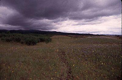
Willamette Floodplain, Natural grassland area in Benton County, Oregon, US

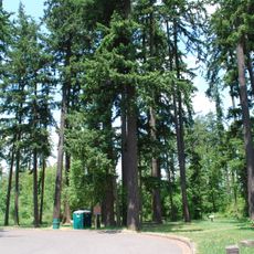
The Willamette Floodplain is a bottomland grassland covering several hundred acres within the William L. Finley National Wildlife Refuge south of Corvallis in Oregon. The area supports native plant communities and diverse wildlife typical of the valley's natural systems.

The site received National Natural Landmark status in 1987, recognizing it as an important example of native grassland that had remained largely undisturbed. This designation reflects the area's value as one of the few remaining representatives of the valley's original vegetation.

Researchers and ecologists study the floodplain's native plant communities and wildlife habitats to understand the valley's original environmental characteristics.

The site is accessible through the wildlife refuge, which provides several entry points and trails for exploring the grassland. Sturdy footwear is advisable as the ground conditions vary with the season, and paths can be muddy or uneven at times.

Several plant species found here appear on protection lists and are rare elsewhere in the region. These uncommon plants depend on the specific conditions of this grassland and are a key reason the area is protected.

The community of curious travelers

AroundUs brings together thousands of curated places, local tips, and hidden gems, enriched daily by 60,000 contributors worldwide.

Start exploring
Location
GPS coordinates
44.41350,-123.29900
Latest update
December 9, 2025 20:22
Around this place
Reser Stadium
United States of America

Reser Stadium

16.3 km
Gill Coliseum
United States of America

Gill Coliseum

16.5 km
William L. Finley National Wildlife Refuge
United States of America

William L. Finley National Wildlife Refuge

1.9 km
Van Buren Street Bridge
United States of America

Van Buren Street Bridge

17.2 km
Dixon Recreation Center
United States of America

Dixon Recreation Center

16.7 km
Irish Bend Covered Bridge
United States of America

Irish Bend Covered Bridge

17 km
Bell Field
United States of America

Bell Field

16.7 km
Corvallis-Benton County Public Library
United States of America

Corvallis-Benton County Public Library

17.2 km
Whiteside Theatre
United States of America

Whiteside Theatre

17 km
Community Hall
United States of America

Community Hall

17.1 km
Washburne State Wayside
United States of America

Washburne State Wayside

15.3 km
United States of America

LaSells Stewart Center

16.3 km
Corvallis Arts Center
United States of America

Corvallis Arts Center

17 km
Benton County Courthouse
United States of America

Benton County Courthouse

17.1 km
Benton Hotel
United States of America

Benton Hotel

17.1 km
Monroe State Bank Building
United States of America

Monroe State Bank Building

11.1 km
United Presbyterian Church of Shedd
United States of America

United Presbyterian Church of Shedd

16 km
First Congregational Church
United States of America

First Congregational Church

17 km
Dr. Henry S. Pernot House
United States of America

Dr. Henry S. Pernot House

16.9 km
John Bexell House
United States of America

John Bexell House

17.6 km
J. R. Bryson House
United States of America

J. R. Bryson House

17.4 km
John Fiechter House
United States of America

John Fiechter House

1.8 km
Charles and Ibby Whiteside House
United States of America

Charles and Ibby Whiteside House

16.8 km
Charles Gaylord House
United States of America

Charles Gaylord House

17.1 km
Benton County State Bank Building
United States of America

Benton County State Bank Building

17 km
Lame-Smith House
United States of America

Lame-Smith House

14.4 km
Lewis G. Kline House
United States of America

Lewis G. Kline House

17.4 km
George W. Bethers House
United States of America

George W. Bethers House

15.4 km
Show the full map
« Willamette Floodplain - Natural grassland area in Benton County, Oregon, US » is provided by Around Us (aroundus.com). Images and texts are derived from Wikimedia project under a Creative Commons license. You are allowed to copy, distribute, and modify copies of this page, under the conditions set by the license, as long as this note is clearly visible.

Discover hidden gems everywhere you go!

From secret cafés to breathtaking viewpoints, skip the crowded tourist spots and find places that match your style. Our app makes it easy with voice search, smart filtering, route optimization, and insider tips from travelers worldwide. Download now for the complete mobile experience.

Around Us App Screenshot

A unique approach to discovering new places

Le Figaro

All the places worth exploring

France Info

A tailor-made excursion in just a few clicks

20 Minutes

Around Us
Travel Guide & Maps
Download

Send to your phone

QR Code
1

Open the camera app on your mobile.

2

Point at the QR code with your camera. A notification will appear.

3

Tap the notification to open the link.